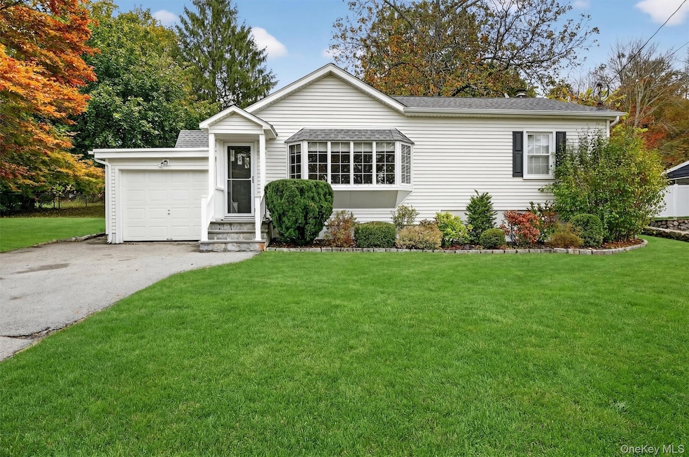
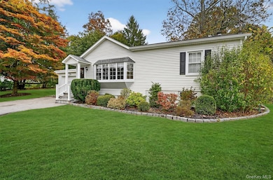
1936 Longvue St Yorktown Heights, NY 10598
Estimated payment $3,928/month
Highlights
- Open Floorplan
- Private Lot
- Cathedral Ceiling
- Yorktown High School Rated A
- Ranch Style House
- 4-minute walk to Junior Lake Park
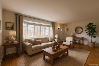
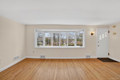
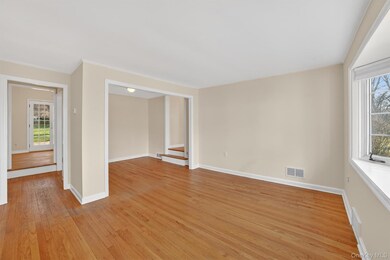
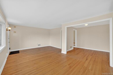
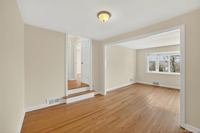
About This Home
Adorable home backing up to the woods yet accessible to everything. All this in walking distance including town pool, The North County Trail System and downtown Yorktown for shopping and restaurants. The open floor plan is ideal for today's lifestyle. The flexibility of the layout gives the opportunity for home office, guest bedroom, and formal dining room. The eat in kitchen boasts two sets of French doors allowing gorgeous natural light. The flow of the outside to inside gives the impression of a much larger home. With a backdrop of an elegant field stone wall, the picture is perfect. A wonderful starter home or ideal down size.
Listing Agent
Houlihan Lawrence Inc. Brokerage Phone: 914-962-4900 License #30DI1063995 Listed on: 12/06/2025

Home Details
Home Type
- Single Family
Est. Annual Taxes
- $12,448
Year Built
- Built in 1948
Lot Details
- 0.28 Acre Lot
- Private Lot
- Level Lot
- Cleared Lot
- Back and Front Yard
Parking
- 1 Car Garage
- Driveway
Home Design
- Ranch Style House
- Vinyl Siding
Interior Spaces
- 1,180 Sq Ft Home
- Open Floorplan
- Cathedral Ceiling
- Storage
Kitchen
- Oven
- Microwave
- Dishwasher
Bedrooms and Bathrooms
- 3 Bedrooms
- Bathroom on Main Level
- 2 Full Bathrooms
Laundry
- Dryer
- Washer
Basement
- Partial Basement
- Basement Storage
Schools
- Brookside Elementary School Campus
- Mildred E Strang Middle School
- Yorktown High School
Utilities
- Central Air
- Heating Available
- Phone Available
- Cable TV Available
Listing and Financial Details
- Assessor Parcel Number 5400-037-015-00002-000-0072
Map
Home Values in the Area
Average Home Value in this Area
Tax History
| Year | Tax Paid | Tax Assessment Tax Assessment Total Assessment is a certain percentage of the fair market value that is determined by local assessors to be the total taxable value of land and additions on the property. | Land | Improvement |
|---|---|---|---|---|
| 2024 | $12,355 | $7,800 | $1,050 | $6,750 |
| 2023 | $12,059 | $7,800 | $1,050 | $6,750 |
| 2022 | $11,704 | $7,800 | $1,050 | $6,750 |
| 2021 | $11,529 | $7,800 | $1,050 | $6,750 |
| 2020 | $11,456 | $7,800 | $1,050 | $6,750 |
| 2019 | $9,203 | $7,800 | $1,050 | $6,750 |
| 2018 | $11,990 | $7,800 | $1,050 | $6,750 |
| 2017 | $5,579 | $7,800 | $1,050 | $6,750 |
| 2016 | $18,152 | $7,800 | $1,050 | $6,750 |
| 2015 | -- | $7,800 | $1,050 | $6,750 |
| 2014 | -- | $7,550 | $1,050 | $6,500 |
| 2013 | -- | $7,550 | $1,050 | $6,500 |
Purchase History
| Date | Type | Sale Price | Title Company |
|---|---|---|---|
| Executors Deed | $332,500 | Chicago Title Insurance Co | |
| Deed | $190,000 | First American Title Ins Co |
Mortgage History
| Date | Status | Loan Amount | Loan Type |
|---|---|---|---|
| Open | $328,081 | FHA |
Source: OneKey® MLS
MLS Number: 925292
APN: 5400-037-015-00002-000-0072
Disclaimer: Certain information contained herein is derived from information provided by parties other than Homes.com. All information provided is deemed reliable, but is not guaranteed to be accurate and should be independently verified.
![]() The data relating to real estate for sale or lease on this web site comes in part from OneKey® MLS. Real estate listings held by brokerage firms other than Ten-X are marked with the OneKey® MLS logo or an abbreviated logo and detailed information about them includes the name of the listing broker.
The data relating to real estate for sale or lease on this web site comes in part from OneKey® MLS. Real estate listings held by brokerage firms other than Ten-X are marked with the OneKey® MLS logo or an abbreviated logo and detailed information about them includes the name of the listing broker.
IDX information is provided exclusively for personal, non-commercial use, and may not be used for any purpose other than to identify prospective properties consumers may be interested in purchasing.
Information is deemed reliable but not guaranteed.
Copyright 2025 OneKey® MLS. All rights reserved.
- 147 Halyan Rd
- 1824 Commerce St
- 1699 Hanover St
- 31 Greenlawn Rd
- 27 Sun Hill Rd
- 2040 Crompond Rd Unit 12
- 2040 Crompond Rd Unit 14
- 2040 Crompond Rd Unit 18
- 2040 Crompond Rd Unit 6
- 2040 Crompond Rd Unit 23
- 2040 Crompond Rd Unit 22
- 2040 Crompond Rd Unit 19
- 2040 Crompond Rd Unit 21
- 2040 Crompond Rd Unit 17
- 2040 Crompond Rd Unit 7
- 2040 Crompond Rd Unit 15
- 9 Sun Hill Rd
- 35 Greenlawn Rd
- Lot 2 Dorchestcher Dr
- 4 Dorchester Dr
- 2097 Saw Mill River Rd Unit C
- 177 Virginia Rd
- 11 Woods Brooke Ln Unit 1
- 2355 Vista Ct
- 12 Logging Rd
- 2796 Old Yorktown Rd
- 3208 Douglas Dr
- 830 Barberry Rd
- 3 Old Tomahawk St Unit B
- 157 Route 100
- 2130 Hunterbrook Rd
- 14 Quicks Ln
- 188 Long Hill Dr Unit 188 Long Hill Drive
- 36 Anderson Rd Unit 2
- 913 Parkway Place
- 56 Krystal Dr
- 49 Clayton Blvd Unit FL2-ID2194A
- 49 Clayton Blvd Unit FL1-ID1269A
- 49 Clayton Blvd Unit FL2-ID2216A
- 49 Clayton Blvd Unit FL1-ID3466A