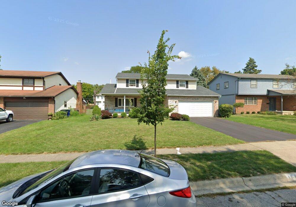
1936 Torchwood Dr Columbus, OH 43229
Forest Park East NeighborhoodEstimated Value: $325,002 - $376,000
4
Beds
3
Baths
2,088
Sq Ft
$167/Sq Ft
Est. Value
About This Home
This home is located at 1936 Torchwood Dr, Columbus, OH 43229 and is currently estimated at $349,501, approximately $167 per square foot. 1936 Torchwood Dr is a home located in Franklin County with nearby schools including Forest Park Elementary School, Woodward Park Middle School, and Northland High School.
Ownership History
Date
Name
Owned For
Owner Type
Purchase Details
Closed on
Nov 9, 2010
Sold by
Mertens Robert Lee and Mertens Miriam H
Bought by
Murray Mark A and Murray Kathie
Current Estimated Value
Home Financials for this Owner
Home Financials are based on the most recent Mortgage that was taken out on this home.
Original Mortgage
$79,700
Outstanding Balance
$1,198
Interest Rate
4.31%
Mortgage Type
Purchase Money Mortgage
Estimated Equity
$348,303
Purchase Details
Closed on
Mar 30, 1984
Bought by
Mertens Robert L
Create a Home Valuation Report for This Property
The Home Valuation Report is an in-depth analysis detailing your home's value as well as a comparison with similar homes in the area
Home Values in the Area
Average Home Value in this Area
Purchase History
| Date | Buyer | Sale Price | Title Company |
|---|---|---|---|
| Murray Mark A | $124,700 | Valmer Land | |
| Mertens Robert L | $65,300 | -- |
Source: Public Records
Mortgage History
| Date | Status | Borrower | Loan Amount |
|---|---|---|---|
| Open | Murray Mark A | $79,700 |
Source: Public Records
Tax History Compared to Growth
Tax History
| Year | Tax Paid | Tax Assessment Tax Assessment Total Assessment is a certain percentage of the fair market value that is determined by local assessors to be the total taxable value of land and additions on the property. | Land | Improvement |
|---|---|---|---|---|
| 2024 | $4,573 | $101,890 | $19,640 | $82,250 |
| 2023 | $4,514 | $101,885 | $19,635 | $82,250 |
| 2022 | $3,703 | $71,400 | $12,530 | $58,870 |
| 2021 | $3,710 | $71,400 | $12,530 | $58,870 |
| 2020 | $3,715 | $71,400 | $12,530 | $58,870 |
| 2019 | $3,139 | $51,740 | $9,280 | $42,460 |
| 2018 | $2,883 | $51,740 | $9,280 | $42,460 |
| 2017 | $3,137 | $51,740 | $9,280 | $42,460 |
| 2016 | $2,901 | $43,790 | $8,720 | $35,070 |
| 2015 | $2,633 | $43,790 | $8,720 | $35,070 |
| 2014 | $2,640 | $43,790 | $8,720 | $35,070 |
| 2013 | $1,431 | $48,125 | $9,170 | $38,955 |
Source: Public Records
Map
Nearby Homes
- 1914 Walden Dr
- 5485 Tamarack Blvd
- 1722 Blue Ash Place
- 1881 Brimfield Rd
- 5204 Honeytree Loop W
- 2084 Brookfield Rd
- 1982 Tupsfield Rd
- 1687 Brookfield Square S
- 5726 Beechcroft Rd Unit J
- 5124 Northcliff Loop W
- 5732 Beechcroft Rd Unit B
- 1752 Pine Tree St S Unit H
- 5727 Tamarack Blvd Unit A
- 1743 Pine Tree St N Unit A
- 2058 Northcliff Dr
- 5056 Northtowne Blvd Unit 5054
- 2294 Teakwood Dr
- 5231 Arrowood Ct
- 1704 Riverbirch Dr
- 5522 Parkshire Dr Unit 5522
- 1944 Torchwood Dr
- 1926 Torchwood Dr
- 1939 Cedar Willow Dr
- 1931 Cedar Willow Dr
- 1954 Torchwood Dr
- 1947 Cedar Willow Dr
- 1921 Cedar Willow Dr
- 1931 Torchwood Dr
- 1941 Torchwood Dr
- 1955 Cedar Willow Dr
- 1962 Torchwood Dr
- 1923 Torchwood Dr
- 1915 Cedar Willow Dr
- 1910 Torchwood Dr
- 1959 Torchwood Dr
- 1963 Cedar Willow Dr
- 1915 Torchwood Dr
- 1907 Cedar Willow Dr
- 5411 Aspen Rd
- 1900 Torchwood Dr