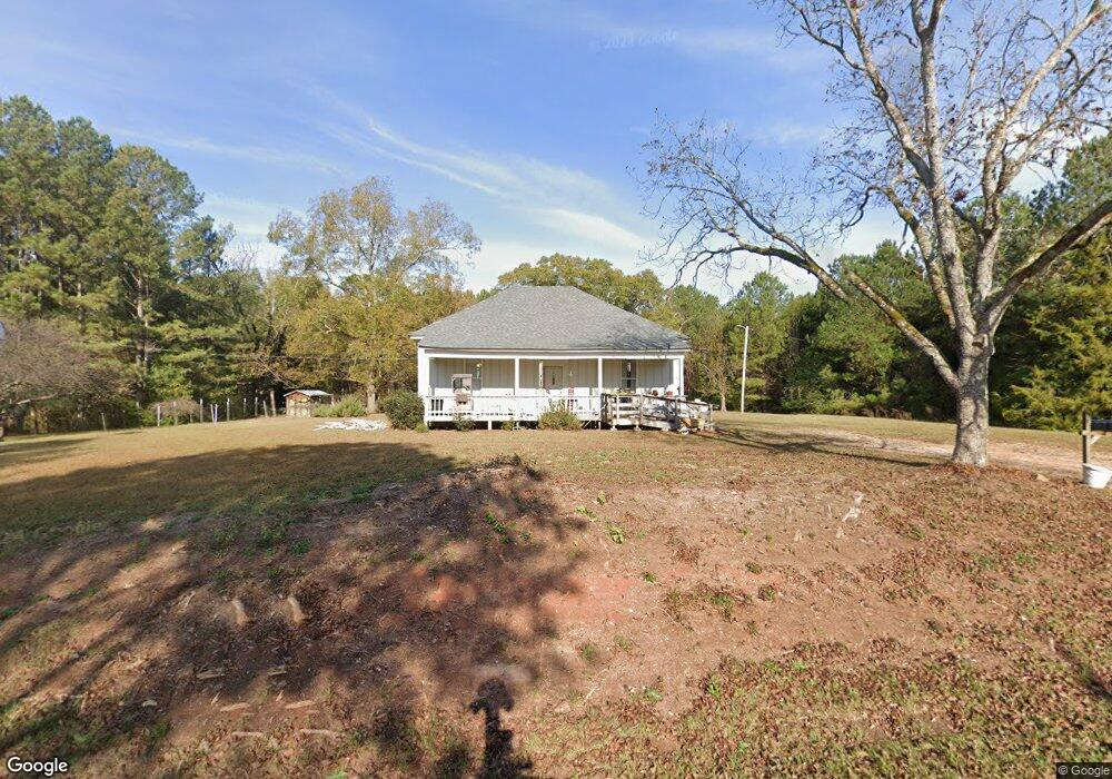
1937 Stovall Rd Lagrange, GA 30241
Estimated Value: $198,024 - $256,000
2
Beds
2
Baths
1,548
Sq Ft
$147/Sq Ft
Est. Value
About This Home
This home is located at 1937 Stovall Rd, Lagrange, GA 30241 and is currently estimated at $227,012, approximately $146 per square foot. 1937 Stovall Rd is a home located in Troup County with nearby schools including Rosemont Elementary School, Whitesville Road Elementary School, and Berta Weathersbee Elementary School.
Ownership History
Date
Name
Owned For
Owner Type
Purchase Details
Closed on
Sep 1, 2017
Sold by
Morman Sandra I
Bought by
Morman Michael R
Current Estimated Value
Home Financials for this Owner
Home Financials are based on the most recent Mortgage that was taken out on this home.
Original Mortgage
$45,000
Interest Rate
3.93%
Mortgage Type
New Conventional
Purchase Details
Closed on
Jan 22, 1999
Sold by
Violet Adamson
Bought by
Adamson Barbara
Purchase Details
Closed on
Nov 26, 1998
Bought by
Violet Adamson
Purchase Details
Closed on
Jul 2, 1992
Sold by
Adamson Violet Marie
Purchase Details
Closed on
Jul 1, 1992
Sold by
Adamson L L
Bought by
Adamson Violet Marie
Purchase Details
Closed on
Jun 16, 1955
Sold by
Humphrey Est
Bought by
Adamson L L
Create a Home Valuation Report for This Property
The Home Valuation Report is an in-depth analysis detailing your home's value as well as a comparison with similar homes in the area
Purchase History
| Date | Buyer | Sale Price | Title Company |
|---|---|---|---|
| Morman Michael R | -- | -- | |
| Morman Sandra I | $44,000 | -- | |
| Adamson Barbara | -- | -- | |
| Violet Adamson | -- | -- | |
| -- | -- | -- | |
| Adamson Violet Marie | -- | -- | |
| Adamson L L | -- | -- |
Source: Public Records
Mortgage History
| Date | Status | Borrower | Loan Amount |
|---|---|---|---|
| Previous Owner | Morman Michael R | $45,000 |
Source: Public Records
Tax History
| Year | Tax Paid | Tax Assessment Tax Assessment Total Assessment is a certain percentage of the fair market value that is determined by local assessors to be the total taxable value of land and additions on the property. | Land | Improvement |
|---|---|---|---|---|
| 2025 | $1,237 | $45,360 | $12,320 | $33,040 |
| 2024 | $1,118 | $41,004 | $12,320 | $28,684 |
| 2023 | $983 | $36,052 | $12,320 | $23,732 |
| 2022 | $949 | $34,012 | $12,320 | $21,692 |
| 2021 | $662 | $21,956 | $12,240 | $9,716 |
| 2020 | $662 | $21,956 | $12,240 | $9,716 |
| 2019 | $654 | $21,700 | $12,240 | $9,460 |
| 2018 | $629 | $20,840 | $12,240 | $8,600 |
| 2017 | $421 | $23,912 | $12,240 | $11,672 |
| 2016 | $419 | $23,861 | $12,275 | $11,586 |
| 2015 | $420 | $23,861 | $12,275 | $11,586 |
| 2014 | $402 | $23,251 | $12,275 | $10,976 |
| 2013 | -- | $24,050 | $12,275 | $11,774 |
Source: Public Records
Map
Nearby Homes
- 158 S Glenn Rd
- 0 Smokey Rd Unit 10570471
- 0 Wadley St Unit 10709450
- 37.23 ACRES / 0 Smokey Rd
- 5656 Hamilton Rd
- 5656 Hamilton Rd
- 0 Leisure Cir Unit 10717962
- 0 Briley Rd Unit 10582531
- 0 Briley Rd Unit 214353
- 7142 Hamilton Rd
- 14 Cherokee Resort Rd
- 12 Cherokee Resort Rd
- 829 Thrash Rd
- 417 Tucker Rd
- 107 S Gates Rd
- 0 Lower Big Springs Rd Unit 10718109
- 0 Lower Big Springs Rd Unit 26695797
- 205+/- Woodard Rd
- 476 Thrash Rd
- 1144 Oak Grove Rd
- 1961 Stovall Rd
- 80 County Line Church Rd
- 1997 Stovall Rd
- 50 County Line Church Rd
- 81 County Line Church Rd
- 2034 Stovall Rd
- 1875 Stovall Rd
- 1824 Stovall Rd
- 98 County Line Church Rd
- 1805 Stovall Rd
- 2076 Stovall Rd
- 1784 Stovall Rd
- 112 County Line Church Rd
- 1727 Stovall Rd
- 2151 Stovall Rd
- 1707 Stovall Rd
- 2194 Stovall Rd
- 1663 Stovall Rd
- 221 Wright Rd
- 1658 Stovall Rd
Your Personal Tour Guide
Ask me questions while you tour the home.