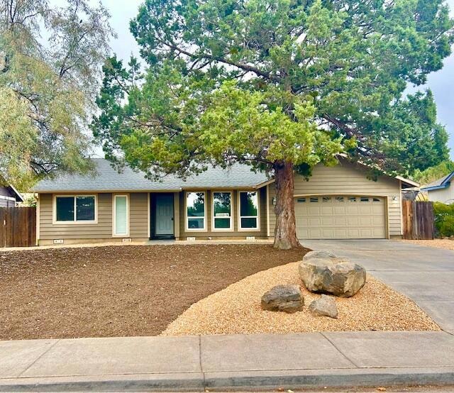
1938 NE Curtis Dr Bend, OR 97701
Mountain View NeighborhoodEstimated payment $2,875/month
Highlights
- Deck
- Ranch Style House
- No HOA
- Territorial View
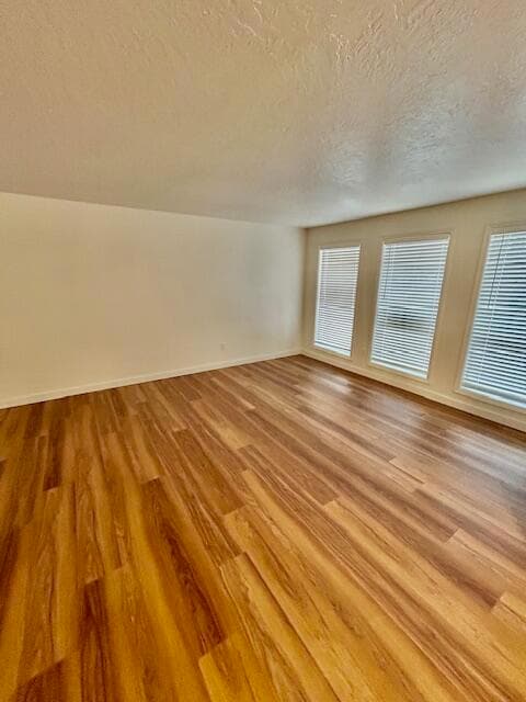
- Engineered Wood Flooring
- 1-minute walk to Mountain View Park
About This Home
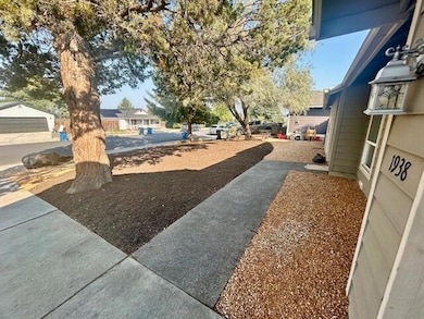
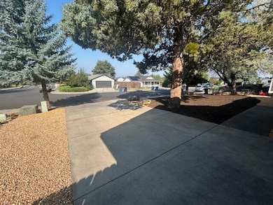
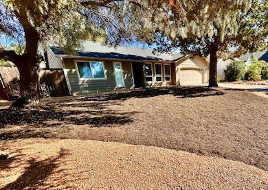
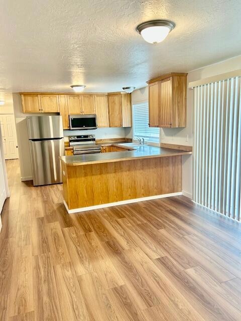
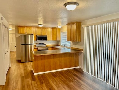
Beautifully maintained home in the desirable Arborwood neighborhood. The front yard features easy-care xeriscaping, offering curb appeal with minimal upkeep. Inside, recent updates include new flooring, window coverings, fresh interior paint, and sleek stainless steel appliances. The inviting floor plan seamlessly connects the kitchen, dining, and living areas, creating a bright, versatile space Ideal for everyday living or entertaining. With three bedrooms and two full bathrooms, the home combines comfort with functionality. Quality finishes throughout highlight its modern, refreshed feel. A spacious two-car garage and fully fenced backyard provide additional privacy and room to relax, garden, or host gatherings. Nestled on a quiet street with quick access to parks, shopping, schools, and medical facilities, this move in ready home blends convenience, style, and low-maintenance living.
Home Details
Home Type
- Single Family
Est. Annual Taxes
- $3,128
Year Built
- Built in 1995
Lot Details
- 6,534 Sq Ft Lot
- Fenced
- Xeriscape Landscape
- Property is zoned RS, RS
Parking
- 2 Car Attached Garage
- Driveway
Property Views
- Territorial
- Neighborhood
Home Design
- Ranch Style House
- Traditional Architecture
- Stem Wall Foundation
- Frame Construction
- Composition Roof
- Concrete Perimeter Foundation
Interior Spaces
- 1,336 Sq Ft Home
- Double Pane Windows
- Vinyl Clad Windows
- Living Room
- Laundry Room
Kitchen
- Eat-In Kitchen
- Breakfast Bar
- Range
- Microwave
- Dishwasher
- Laminate Countertops
- Disposal
Flooring
- Engineered Wood
- Laminate
Bedrooms and Bathrooms
- 3 Bedrooms
- Linen Closet
- 2 Full Bathrooms
- Bathtub with Shower
Home Security
- Carbon Monoxide Detectors
- Fire and Smoke Detector
Outdoor Features
- Deck
Schools
- Buckingham Elementary School
- Pilot Butte Middle School
- Mountain View Sr High School
Utilities
- No Cooling
- Wall Furnace
- Water Heater
- Phone Available
- Cable TV Available
Listing and Financial Details
- Tax Lot 00204
- Assessor Parcel Number 187653
Community Details
Overview
- No Home Owners Association
- Arborwood Subdivision
Recreation
- Community Playground
- Park
Map
Home Values in the Area
Average Home Value in this Area
Tax History
| Year | Tax Paid | Tax Assessment Tax Assessment Total Assessment is a certain percentage of the fair market value that is determined by local assessors to be the total taxable value of land and additions on the property. | Land | Improvement |
|---|---|---|---|---|
| 2025 | $3,251 | $192,430 | -- | -- |
| 2024 | $3,128 | $186,830 | -- | -- |
| 2023 | $2,900 | $181,390 | $0 | $0 |
| 2022 | $2,706 | $170,990 | $0 | $0 |
| 2021 | $2,710 | $166,010 | $0 | $0 |
| 2020 | $2,571 | $166,010 | $0 | $0 |
| 2019 | $2,499 | $161,180 | $0 | $0 |
| 2018 | $2,429 | $156,490 | $0 | $0 |
| 2017 | $2,358 | $151,940 | $0 | $0 |
| 2016 | $2,248 | $147,520 | $0 | $0 |
| 2015 | $2,186 | $143,230 | $0 | $0 |
| 2014 | $2,122 | $139,060 | $0 | $0 |
Property History
| Date | Event | Price | List to Sale | Price per Sq Ft |
|---|---|---|---|---|
| 11/08/2025 11/08/25 | Pending | -- | -- | -- |
| 11/07/2025 11/07/25 | Price Changed | $495,000 | -2.0% | $371 / Sq Ft |
| 10/17/2025 10/17/25 | For Sale | $505,000 | -- | $378 / Sq Ft |
Purchase History
| Date | Type | Sale Price | Title Company |
|---|---|---|---|
| Bargain Sale Deed | -- | None Listed On Document | |
| Warranty Deed | $105,000 | Amerititle | |
| Warranty Deed | -- | Amerititle |
Mortgage History
| Date | Status | Loan Amount | Loan Type |
|---|---|---|---|
| Previous Owner | $168,900 | Fannie Mae Freddie Mac |
Source: Oregon Datashare
MLS Number: 220210710
APN: 187653
Disclaimer: Certain information contained herein is derived from information provided by parties other than Homes.com. All information provided is deemed reliable, but is not guaranteed to be accurate and should be independently verified.
![]() © 2025 Oregon Datashare (KCAR | MLSCO | SOMLS). All rights reserved. The data relating to real estate for sale on this web site comes in part from the Internet Data Exchange Program of the Oregon Datashare. Real estate listings held by IDX Brokerage firms other than Ten-X are marked with the Internet Data Exchange logo or the Internet Data Exchange thumbnail logo and detailed information about them includes the name of the listing Brokers. Information provided is for consumers' personal, non-commercial use and may not be used for any purpose other than to identify prospective properties the viewer may be interested in purchasing. The consumer will not copy, retransmit nor redistribute any of the content from this website. Information provided is deemed reliable, but not guaranteed.
© 2025 Oregon Datashare (KCAR | MLSCO | SOMLS). All rights reserved. The data relating to real estate for sale on this web site comes in part from the Internet Data Exchange Program of the Oregon Datashare. Real estate listings held by IDX Brokerage firms other than Ten-X are marked with the Internet Data Exchange logo or the Internet Data Exchange thumbnail logo and detailed information about them includes the name of the listing Brokers. Information provided is for consumers' personal, non-commercial use and may not be used for any purpose other than to identify prospective properties the viewer may be interested in purchasing. The consumer will not copy, retransmit nor redistribute any of the content from this website. Information provided is deemed reliable, but not guaranteed.
- 62466 Eagle Rd
- 62453 Eagle Rd
- 2966 NE Dogwood Dr
- 2741 NE Laramie Way
- 21347 Starling Dr
- 3362 NE Collier Ct
- 62540 Eagle Rd
- 21344 Pelican Dr
- 3325 NE Mendenhall Dr
- 3318 NE Hoona Dr
- 3336 NE Hoona Dr
- 2711 NE Yellow Ribbon Dr
- 2324 NE Halston Ct
- 21420 Belknap Dr
- 21376 Oakview Dr
- 21533 Stony Ridge Rd
- 21442 Belknap Dr
- 62570 NE Loomis Ln Unit Lot 54
- 21445 Bradetich Loop
- 1297 NE Dawson Dr Unit A&B
