Estimated Value: $496,000 - $536,000
4
Beds
2
Baths
1,576
Sq Ft
$331/Sq Ft
Est. Value
About This Home
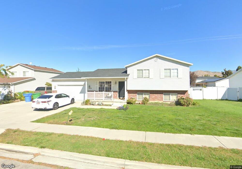
This home is located at 1938 W 1540 N, Lehi, UT 84043 and is currently estimated at $521,949, approximately $331 per square foot. 1938 W 1540 N is a home located in Utah County with nearby schools including North Point Elementary School, Willowcreek Middle School, and Lehi High School.
Ownership History
Date
Name
Owned For
Owner Type
Purchase Details
Closed on
Aug 6, 2021
Sold by
Lesofski Andrew James and Lesofski Emelyn F
Bought by
Lesofski Emelyn F and Lesofski Andrew James
Current Estimated Value
Home Financials for this Owner
Home Financials are based on the most recent Mortgage that was taken out on this home.
Original Mortgage
$206,500
Outstanding Balance
$188,052
Interest Rate
3%
Mortgage Type
New Conventional
Estimated Equity
$333,897
Purchase Details
Closed on
Jun 2, 2021
Sold by
Lesofski Andrew James
Bought by
Lesofski Andrew Jamees and Lesofski Emelyn Faulkner
Purchase Details
Closed on
Apr 14, 2021
Sold by
Neal Stephanie Leone and Snyder Stephanie L
Bought by
Lesofski Andrew James
Purchase Details
Closed on
Oct 26, 2016
Sold by
Snyder Stephanie L and Broderick Stephanie L
Bought by
Snyder Stephanie L
Home Financials for this Owner
Home Financials are based on the most recent Mortgage that was taken out on this home.
Original Mortgage
$214,489
Interest Rate
3.5%
Mortgage Type
FHA
Purchase Details
Closed on
Dec 4, 2014
Sold by
Jensen Craig P and Jensen Stephanie A
Bought by
Broderick Stephanie A
Home Financials for this Owner
Home Financials are based on the most recent Mortgage that was taken out on this home.
Original Mortgage
$212,657
Interest Rate
4.4%
Mortgage Type
FHA
Purchase Details
Closed on
Mar 7, 2003
Sold by
Trane Andrew C and Trane Alisha A
Bought by
Jensen Craig P and Jensen Stephanie A
Home Financials for this Owner
Home Financials are based on the most recent Mortgage that was taken out on this home.
Original Mortgage
$120,400
Interest Rate
5.5%
Purchase Details
Closed on
Dec 18, 1998
Sold by
Salisbury Development Lc
Bought by
Trane Andrew C and Trane Alisha A
Home Financials for this Owner
Home Financials are based on the most recent Mortgage that was taken out on this home.
Original Mortgage
$107,000
Interest Rate
6.86%
Create a Home Valuation Report for This Property
The Home Valuation Report is an in-depth analysis detailing your home's value as well as a comparison with similar homes in the area
Home Values in the Area
Average Home Value in this Area
Purchase History
| Date | Buyer | Sale Price | Title Company |
|---|---|---|---|
| Lesofski Emelyn F | -- | Us Title Ins Agency | |
| Lesofski Andrew Jamees | -- | None Available | |
| Lesofski Andrew James | -- | Inwest Title Services Inc | |
| Snyder Stephanie L | -- | Highland Title | |
| Broderick Stephanie A | -- | Eagle Pointe Title Insurance | |
| Jensen Craig P | -- | Precision Title Company | |
| Trane Andrew C | -- | Provo Land Title Company |
Source: Public Records
Mortgage History
| Date | Status | Borrower | Loan Amount |
|---|---|---|---|
| Open | Lesofski Emelyn F | $206,500 | |
| Previous Owner | Snyder Stephanie L | $214,489 | |
| Previous Owner | Broderick Stephanie A | $212,657 | |
| Previous Owner | Jensen Craig P | $120,400 | |
| Previous Owner | Trane Andrew C | $107,000 | |
| Closed | Jensen Craig P | $30,100 |
Source: Public Records
Tax History Compared to Growth
Tax History
| Year | Tax Paid | Tax Assessment Tax Assessment Total Assessment is a certain percentage of the fair market value that is determined by local assessors to be the total taxable value of land and additions on the property. | Land | Improvement |
|---|---|---|---|---|
| 2025 | $1,988 | $254,705 | $194,200 | $268,900 |
| 2024 | $1,988 | $232,650 | $0 | $0 |
| 2023 | $1,844 | $234,355 | $0 | $0 |
| 2022 | $1,982 | $244,200 | $0 | $0 |
| 2021 | $1,760 | $327,700 | $112,400 | $215,300 |
| 2020 | $1,659 | $305,300 | $104,100 | $201,200 |
| 2019 | $1,461 | $279,600 | $104,100 | $175,500 |
| 2018 | $1,372 | $248,300 | $92,800 | $155,500 |
| 2017 | $1,332 | $128,095 | $0 | $0 |
| 2016 | $1,308 | $116,765 | $0 | $0 |
| 2015 | $1,328 | $112,475 | $0 | $0 |
| 2014 | $1,195 | $100,650 | $0 | $0 |
Source: Public Records
Map
Nearby Homes
- 1542 N 1900 W
- 1648 N 1900 W
- 1908 N 2230 W
- 1896 N 2230 W
- 1870 N 2230 W
- 1659 W Boxwood Dr Unit 109
- 1627 W Boxwood Dr Unit 110
- 1970 N 2090 St W
- Huntington Plan at Pioneer Meadows
- Silver Lake Plan at Pioneer Meadows
- Summit Plan at Pioneer Meadows
- Palisade Plan at Pioneer Meadows
- 1332 W 1500 N
- 1127 N 1500 W
- 2012 N 2040 W
- 1969 N 2040 St W
- 1968 N 2040 W
- 2013 N 2040 W
- 1990 N 2040 W
- 1898 W Pointe Meadow Loop