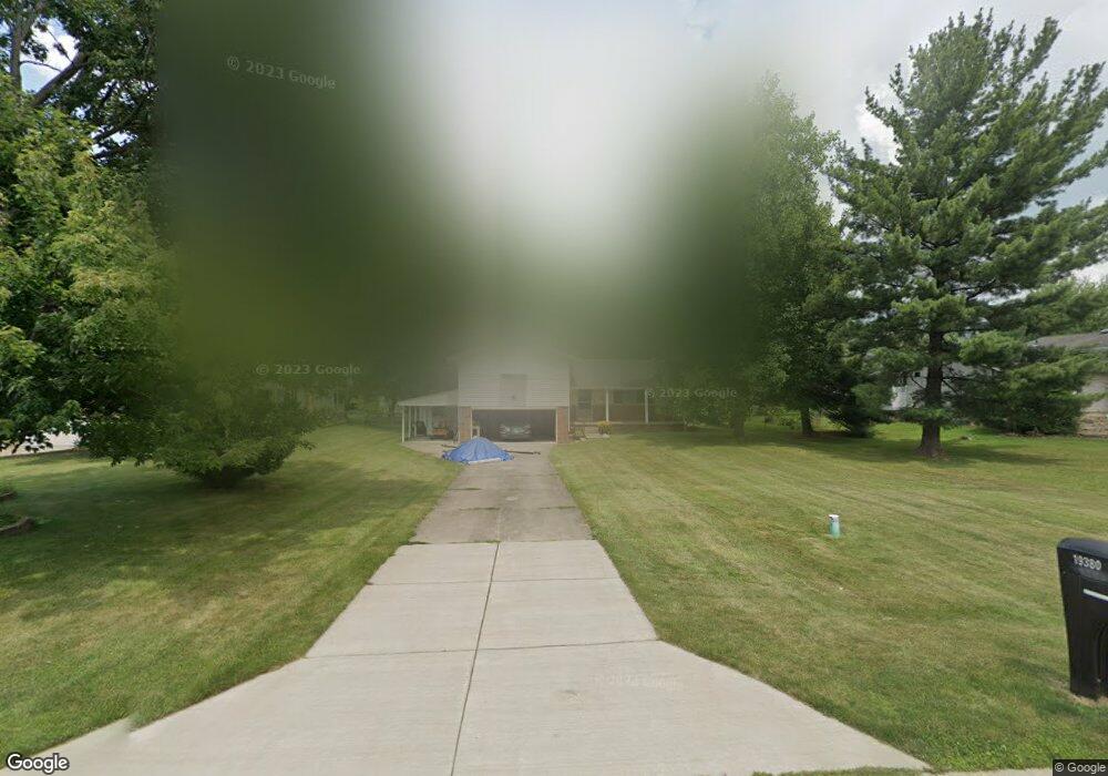
19380 Bowman Dr Strongsville, OH 44149
Estimated Value: $261,128 - $285,000
3
Beds
2
Baths
1,640
Sq Ft
$169/Sq Ft
Est. Value
About This Home
This home is located at 19380 Bowman Dr, Strongsville, OH 44149 and is currently estimated at $277,032, approximately $168 per square foot. 19380 Bowman Dr is a home located in Cuyahoga County with nearby schools including Strongsville High School, Strongsville Academy, and Sts Joseph & John Interparochial School.
Ownership History
Date
Name
Owned For
Owner Type
Purchase Details
Closed on
May 27, 2021
Sold by
Wick Bruce Tyler and Estate Of Patricia Donna Green
Bought by
Edmondson Robert D
Current Estimated Value
Home Financials for this Owner
Home Financials are based on the most recent Mortgage that was taken out on this home.
Original Mortgage
$122,400
Outstanding Balance
$110,818
Interest Rate
2.9%
Mortgage Type
New Conventional
Estimated Equity
$166,214
Purchase Details
Closed on
May 13, 2004
Sold by
Greene Ernest A and Greene Patricia D
Bought by
Greene Ernest A and Greene Patricia D
Purchase Details
Closed on
Jan 1, 1975
Bought by
Greene Ernest A and Greene Pd
Create a Home Valuation Report for This Property
The Home Valuation Report is an in-depth analysis detailing your home's value as well as a comparison with similar homes in the area
Home Values in the Area
Average Home Value in this Area
Purchase History
| Date | Buyer | Sale Price | Title Company |
|---|---|---|---|
| Edmondson Robert D | $153,000 | Chicago Title Insurance C | |
| Greene Ernest A | -- | Mountaineer Title Agency | |
| Turmbau Llc | $12,859 | Mountaineer Title Agency | |
| Greene Ernest A | -- | -- |
Source: Public Records
Mortgage History
| Date | Status | Borrower | Loan Amount |
|---|---|---|---|
| Open | Edmondson Robert D | $122,400 |
Source: Public Records
Tax History Compared to Growth
Tax History
| Year | Tax Paid | Tax Assessment Tax Assessment Total Assessment is a certain percentage of the fair market value that is determined by local assessors to be the total taxable value of land and additions on the property. | Land | Improvement |
|---|---|---|---|---|
| 2024 | $4,342 | $85,470 | $15,820 | $69,650 |
| 2023 | $4,315 | $61,820 | $15,720 | $46,100 |
| 2022 | $4,160 | $61,810 | $15,720 | $46,100 |
| 2021 | $3,633 | $61,810 | $15,720 | $46,100 |
| 2020 | $3,403 | $54,220 | $13,790 | $40,430 |
| 2019 | $3,419 | $154,900 | $39,400 | $115,500 |
| 2018 | $2,792 | $54,220 | $13,790 | $40,430 |
| 2017 | $2,727 | $49,850 | $11,240 | $38,610 |
| 2016 | $2,704 | $49,850 | $11,240 | $38,610 |
| 2015 | $2,647 | $49,850 | $11,240 | $38,610 |
| 2014 | $2,647 | $48,410 | $10,920 | $37,490 |
Source: Public Records
Map
Nearby Homes
- 17259 Woodshire Dr
- 19297 Lauren Way
- 20393 Wildwood Ln
- 19311 Bradford Ct
- 20114 Drake Rd
- 20121 Driftwood Ct
- 19908 Stoughton Dr
- 18294 Drake Rd
- 17934 Cambridge Oval
- 18411 Yorktown Oval
- 18162 Fawn Cir
- 20556 Drake Rd
- 20086 Bradgate Ln
- 18848 Pearl Rd
- 20592 Drake Rd
- 17024 Bear Creek Ln
- 15279 Walnut Creek Dr
- 17682 Drake Rd
- 17069 Partridge Dr
- 19513 Lunn Rd
- 19388 Bowman Dr
- 19322 Bowman Dr
- 19418 Bowman Dr
- 19292 Bowman Dr
- 17293 Woodshire Dr
- 17327 Woodshire Dr
- 17225 Woodshire Dr
- 17337 Fetzer Dr
- 17497 Woodshire Dr
- 17361 Woodshire Dr
- 19454 Bowman Dr
- 17463 Woodshire Dr
- 17429 Woodshire Dr
- 19319 Bowman Dr
- 19355 Bowman Dr
- 17531 Woodshire Dr
- 19262 Bowman Dr
- 17395 Woodshire Dr
- 17191 Woodshire Dr
- 17339 Fetzer Dr