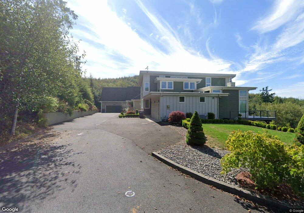
1939 N Fork Ct Seaside, OR 97138
Estimated Value: $753,000 - $967,000
3
Beds
53
Baths
2,613
Sq Ft
$330/Sq Ft
Est. Value
About This Home
This home is located at 1939 N Fork Ct, Seaside, OR 97138 and is currently estimated at $861,414, approximately $329 per square foot. 1939 N Fork Ct is a home located in Clatsop County with nearby schools including Seaside High School.
Ownership History
Date
Name
Owned For
Owner Type
Purchase Details
Closed on
Nov 9, 2021
Sold by
Thacker Barbara G and Edwards Richard O
Bought by
Fuller Pamela J and Fuller William L
Current Estimated Value
Home Financials for this Owner
Home Financials are based on the most recent Mortgage that was taken out on this home.
Original Mortgage
$215,000
Outstanding Balance
$196,652
Interest Rate
3.01%
Mortgage Type
New Conventional
Estimated Equity
$664,762
Purchase Details
Closed on
Jul 13, 2011
Sold by
Olstedt Construction Inc
Bought by
Thacker Barbara G and Edwards Richard O
Create a Home Valuation Report for This Property
The Home Valuation Report is an in-depth analysis detailing your home's value as well as a comparison with similar homes in the area
Purchase History
| Date | Buyer | Sale Price | Title Company |
|---|---|---|---|
| Fuller Pamela J | $815,000 | Ticor Title Company Of Or | |
| Thacker Barbara G | $100,000 | None Available |
Source: Public Records
Mortgage History
| Date | Status | Borrower | Loan Amount |
|---|---|---|---|
| Open | Fuller Pamela J | $215,000 |
Source: Public Records
Tax History
| Year | Tax Paid | Tax Assessment Tax Assessment Total Assessment is a certain percentage of the fair market value that is determined by local assessors to be the total taxable value of land and additions on the property. | Land | Improvement |
|---|---|---|---|---|
| 2025 | $5,534 | $411,277 | -- | -- |
| 2024 | $5,362 | $399,299 | -- | -- |
| 2023 | $5,206 | $387,670 | $0 | $0 |
| 2022 | $5,481 | $376,379 | $0 | $0 |
| 2021 | $5,366 | $365,417 | $0 | $0 |
| 2020 | $5,242 | $354,775 | $0 | $0 |
| 2019 | $5,101 | $344,442 | $0 | $0 |
Source: Public Records
Map
Nearby Homes
- 2285 N Fork Rd
- 2188 Stanley Lake Ct
- 2344 Royal View Dr
- 2110 Thompson Falls Dr
- 2550 Boehm Acres Rd
- 2657 N Hwy 101 Unit 6
- 481 Hillside Loop
- 0 Cross Creek St Unit 12
- 0 Cross Creek St Unit 10
- 0 Cross Creek St Unit 11
- 0 Cross Creek St Unit 26-112
- 0 Cross Creek St Unit 13
- 0 Cross Creek St Unit 26-114
- 0 Cross Creek St Unit 26-115
- 0 Cross Creek St Unit 26-116
- 0 Cross Creek St Unit 14
- 0 Cross Creek St Unit 26-117
- 0 N Wahanna Rd
- 2674 U S 101
- 1350 13th Ave
- 1939 N Fork Rd
- 1927 N Fork Rd
- 1915 North Fork
- 1903 N Fork Ct
- 1915 N Fork Ct
- 1903 N Fork Rd
- 1903 N Fork
- 0 Necanicum 45 Spur
- 1980 1weuoqtd6zpd Fork 1weuounxpaq3
- 1980 N Fork Ct
- 2295 N Fork Rd Unit 51
- 2295 N Fork Rd
- 1980 N Fork Rd
- 1980 N Fork Rd Unit 32
- 2317 N Fork Rd
- 1992 N Fork Rd Unit 33
- 1992 N Fork Rd
- 2294 North Fork Rd
- 2275 N Fork Rd Unit 53
- 2333 N Fork Rd
Your Personal Tour Guide
Ask me questions while you tour the home.