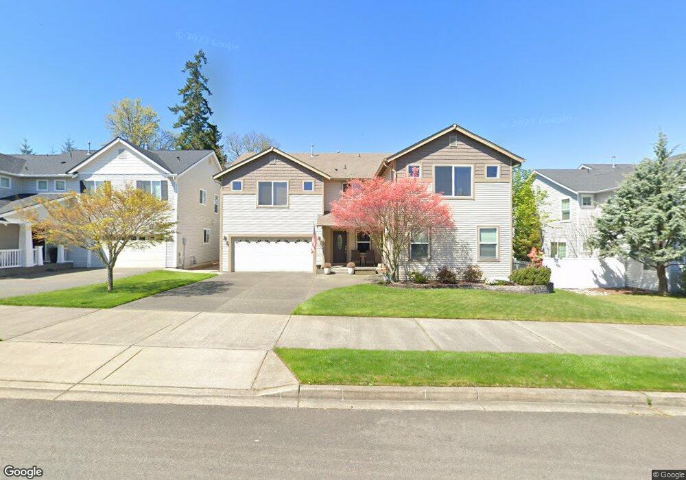
1939 Ogden Ave Dupont, WA 98327
Estimated Value: $724,000 - $807,000
4
Beds
4
Baths
3,730
Sq Ft
$207/Sq Ft
Est. Value
About This Home
This home is located at 1939 Ogden Ave, Dupont, WA 98327 and is currently estimated at $771,069, approximately $206 per square foot. 1939 Ogden Ave is a home located in Pierce County with nearby schools including Chloe Clark Elementary School, Saltars Point Elementary School, and Pioneer Middle School.
Ownership History
Date
Name
Owned For
Owner Type
Purchase Details
Closed on
Mar 27, 2006
Sold by
The Quadrant Corp
Bought by
Despars Charles William and Despars Paula M
Current Estimated Value
Home Financials for this Owner
Home Financials are based on the most recent Mortgage that was taken out on this home.
Original Mortgage
$356,384
Outstanding Balance
$203,499
Interest Rate
6.25%
Mortgage Type
VA
Estimated Equity
$567,570
Create a Home Valuation Report for This Property
The Home Valuation Report is an in-depth analysis detailing your home's value as well as a comparison with similar homes in the area
Home Values in the Area
Average Home Value in this Area
Purchase History
| Date | Buyer | Sale Price | Title Company |
|---|---|---|---|
| Despars Charles William | $375,142 | Chicago Title |
Source: Public Records
Mortgage History
| Date | Status | Borrower | Loan Amount |
|---|---|---|---|
| Open | Despars Charles William | $356,384 |
Source: Public Records
Tax History Compared to Growth
Tax History
| Year | Tax Paid | Tax Assessment Tax Assessment Total Assessment is a certain percentage of the fair market value that is determined by local assessors to be the total taxable value of land and additions on the property. | Land | Improvement |
|---|---|---|---|---|
| 2025 | $5,492 | $747,800 | $237,700 | $510,100 |
| 2024 | $5,492 | $711,600 | $229,000 | $482,600 |
| 2023 | $5,492 | $683,000 | $223,400 | $459,600 |
| 2022 | $5,523 | $697,700 | $223,400 | $474,300 |
| 2021 | $5,293 | $526,200 | $141,900 | $384,300 |
| 2019 | $4,765 | $484,000 | $118,300 | $365,700 |
| 2018 | $5,171 | $466,400 | $118,300 | $348,100 |
| 2017 | $4,654 | $443,300 | $103,900 | $339,400 |
| 2016 | $4,452 | $403,700 | $87,600 | $316,100 |
| 2014 | $4,175 | $395,800 | $87,600 | $308,200 |
| 2013 | $4,175 | $351,700 | $89,200 | $262,500 |
Source: Public Records
Map
Nearby Homes
- 2420 Simmons St
- 2357 Wallace St
- 2702 Meyer St
- 2055 Garry Oaks Ave Unit B
- 1875 Mcneil Cir Unit E-1
- 1821 Mcneil Cir Unit D-3
- 1788 Cadborough Ln
- 3073 Hoffman Hill Blvd
- 1856 Spencer Ct Unit 12F
- 2176 McDonald Ave
- 1607 Kincaid St Unit E-8
- 1449 Bobs Hollow Ln
- 1375 Foreman Rd
- 2160 Anderson Ave
- 2237 Tolmie St
- 3178 Hoffman Hill Blvd
- 2176 Palisade Blvd Unit F-3
- 2198 Palisade Blvd Unit C2
- 2104 Palisade Blvd Unit B-7
- 3202 Hoffman Hill Blvd
- 1957 Ogden Ave
- 1925 Ogden Ave
- 1985 Ogden Ave
- 1907 Ogden Ave
- 1956 Ogden Ave
- 1932 Ogden Ave
- 1978 Ogden Ave
- 1994 Ogden Ave
- 1920 Ogden Ave
- 2011 Ogden Ave
- 1957 Homan Ave
- 1935 Homan Ave
- 1969 Homan Ave
- 2505 Wallace St
- 2480 Simmons St Unit B
- 2480 Simmons St Unit A
- 1991 Homan Ave
- 2023 Ogden Ave
- 2612 Wallace St