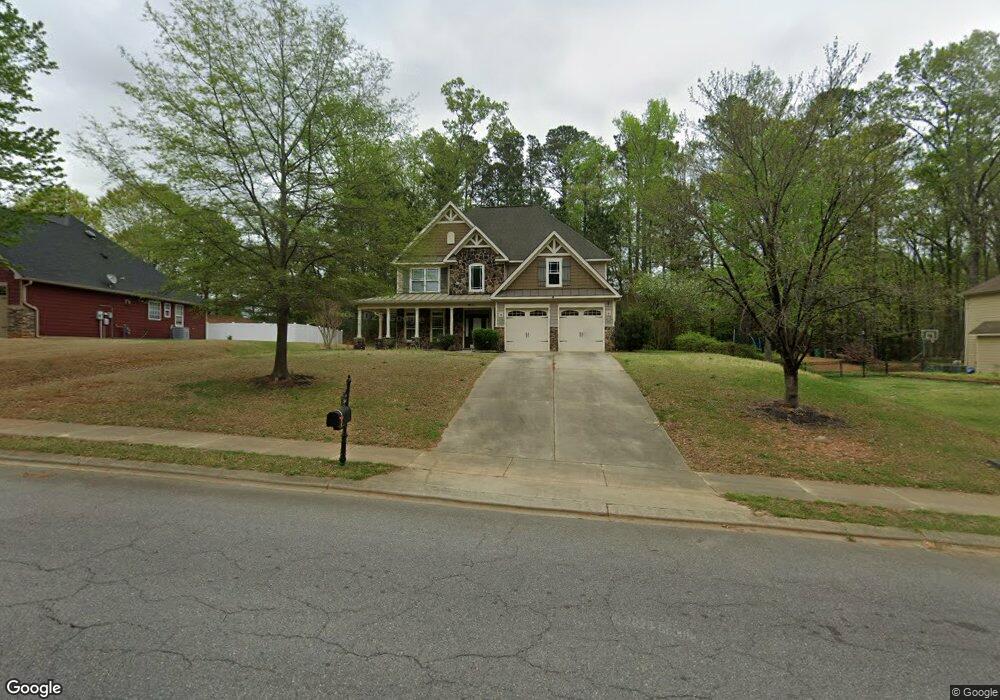
194 Adams Point Dr Garner, NC 27529
Estimated Value: $514,774 - $545,000
4
Beds
3
Baths
3,150
Sq Ft
$167/Sq Ft
Est. Value
About This Home
This home is located at 194 Adams Point Dr, Garner, NC 27529 and is currently estimated at $526,194, approximately $167 per square foot. 194 Adams Point Dr is a home located in Johnston County with nearby schools including West View Elementary School, Cleveland Middle School, and West Johnston High School.
Ownership History
Date
Name
Owned For
Owner Type
Purchase Details
Closed on
Aug 28, 2017
Sold by
Anderson Kevin and Anderson Allison M
Bought by
Smith James T
Current Estimated Value
Home Financials for this Owner
Home Financials are based on the most recent Mortgage that was taken out on this home.
Original Mortgage
$275,488
Outstanding Balance
$227,535
Interest Rate
3.5%
Mortgage Type
FHA
Estimated Equity
$298,659
Purchase Details
Closed on
Oct 23, 2015
Sold by
Marek Debra R
Bought by
Anderson Allison M and Anderson Kevin B
Home Financials for this Owner
Home Financials are based on the most recent Mortgage that was taken out on this home.
Original Mortgage
$274,339
Interest Rate
4.4%
Mortgage Type
FHA
Purchase Details
Closed on
Mar 5, 2007
Sold by
Southpoint Homes Llc
Bought by
Marek Debra R
Home Financials for this Owner
Home Financials are based on the most recent Mortgage that was taken out on this home.
Original Mortgage
$278,750
Interest Rate
8.65%
Mortgage Type
Balloon
Create a Home Valuation Report for This Property
The Home Valuation Report is an in-depth analysis detailing your home's value as well as a comparison with similar homes in the area
Home Values in the Area
Average Home Value in this Area
Purchase History
| Date | Buyer | Sale Price | Title Company |
|---|---|---|---|
| Smith James T | $285,000 | None Available | |
| Anderson Allison M | $279,500 | None Available | |
| Marek Debra R | $293,500 | None Available |
Source: Public Records
Mortgage History
| Date | Status | Borrower | Loan Amount |
|---|---|---|---|
| Open | Smith James T | $275,488 | |
| Previous Owner | Anderson Allison M | $274,339 | |
| Previous Owner | Marek Debra R | $278,750 |
Source: Public Records
Tax History
| Year | Tax Paid | Tax Assessment Tax Assessment Total Assessment is a certain percentage of the fair market value that is determined by local assessors to be the total taxable value of land and additions on the property. | Land | Improvement |
|---|---|---|---|---|
| 2025 | $3,183 | $501,260 | $70,000 | $431,260 |
| 2024 | $2,565 | $316,650 | $48,000 | $268,650 |
| 2023 | $2,478 | $316,650 | $48,000 | $268,650 |
| 2022 | $2,604 | $316,650 | $48,000 | $268,650 |
| 2021 | $2,604 | $316,650 | $48,000 | $268,650 |
| 2020 | $2,636 | $316,650 | $48,000 | $268,650 |
| 2019 | $2,636 | $316,650 | $48,000 | $268,650 |
| 2018 | $2,512 | $294,700 | $44,000 | $250,700 |
| 2017 | $2,512 | $294,700 | $44,000 | $250,700 |
| 2016 | $2,512 | $294,700 | $44,000 | $250,700 |
| 2015 | $2,512 | $294,700 | $44,000 | $250,700 |
| 2014 | $2,512 | $294,700 | $44,000 | $250,700 |
Source: Public Records
Map
Nearby Homes
- 72 Meadowmist Dr
- 181 Fawn Hill Ct
- 236 Fieldtrial Cir
- 232 Fawn Hill Ct
- 58 Trailblazer Ln
- 356 Fieldtrial Cir
- 648 Fieldtrial Cir
- 403 Airedale Trail
- 111 Artic Cir
- 866 Black Angus Dr
- 131 Artic Cir
- 304 Artic Cir
- 368 Artic Cir
- 421 Danielle Dr
- 908 Olive Dr
- 50 Linden Ct
- 36 Norman Ct
- 113 Hogan Dr
- Lot 2a S Shiloh Rd
- 119 Fairbanks Ave
- 364 Adams Point Dr
- 243 Adams Point Dr
- 214 Adams Point Dr
- 174 Adams Point Dr
- 234 Adams Point Dr
- 1715 Old Drug Store Rd
- 1750 Old Drug Store Rd
- 250 Adams Point Dr
- 1701 Old Drug Store Rd
- 1671 Old Drug Store Rd
- 1721 Old Drug Store Rd
- 137 Adams Point Dr
- 270 Adams Point Dr
- 255 Adams Point Dr
- 1643 Old Drug Store Rd
- 1252 Fieldtrial Cir
- 1260 Fieldtrial Cir
- 1278 Fieldtrial Cir
- 1228 Fieldtrial Cir
- 1228 Fieldtrial Cir Unit Carso
Your Personal Tour Guide
Ask me questions while you tour the home.