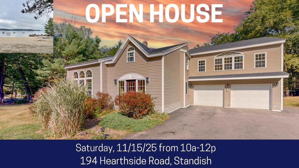
194 Hearthside Rd Standish, ME 04084
North Gorham NeighborhoodEstimated payment $4,199/month
Highlights
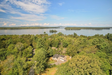
- Deeded Waterfront Access Rights
- Scenic Views
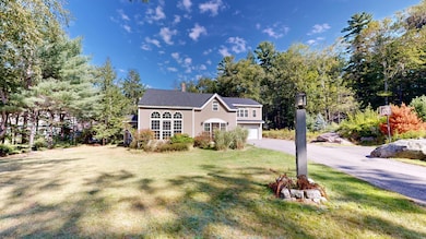
- Contemporary Architecture
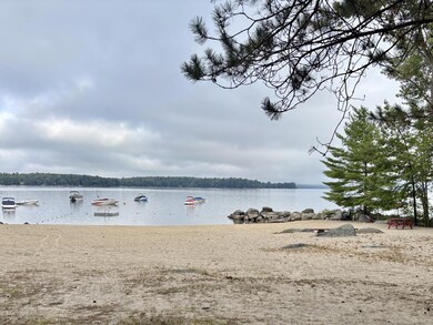
- 300 Feet of Waterfront
- Deck
- Wooded Lot
About This Home
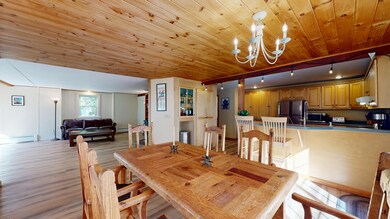
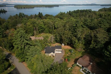
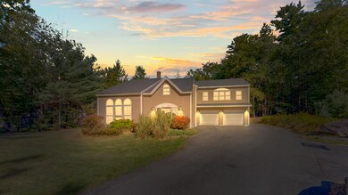
Open House Saturday November 15th from 10am-12pm. Welcome to 194 Hearthside Road, located in a highly desirable, peaceful subdivision on the beautiful shores of Sebago Lake. This sunny contemporary home offers four bedrooms and two and a half baths. It features gorgeous cathedral ceilings and open-concept kitchen, dining, and sunroom spaces. There's a cozy gas fireplace in the sunroom as well as a whole-house generator—just in case you need it! Enjoy the surrounding nature from the large deck or take just a few steps to the shared 300 feet of sandy beach frontage, where you can spend your days boating, fishing, swimming, enjoying all your favorite watersports, and taking in spectacular sunsets each evening. The property includes a boat mooring with the opportunity to join a waitlist for a second. Conveniently located near shopping, restaurants, and St. Joseph's College, and for winter enthusiasts, ski slopes are within a 45-minute drive.
Whether you are searching for a full-time residence or a vacation retreat, this is truly a wonderful home.

Home Details
Home Type
- Single Family
Est. Annual Taxes
- $5,670
Year Built
- Built in 1987
Lot Details
- 0.7 Acre Lot
- 300 Feet of Waterfront
- Wooded Lot
HOA Fees
- $42 Monthly HOA Fees
Parking
- 2 Car Direct Access Garage
- Automatic Garage Door Opener
- Driveway
- Off-Street Parking
Property Views
- Scenic Vista
- Woods
Home Design
- Contemporary Architecture
- Concrete Foundation
- Wood Frame Construction
- Shingle Roof
- Vinyl Siding
- Concrete Perimeter Foundation
Interior Spaces
- 2,570 Sq Ft Home
- Cathedral Ceiling
- Ceiling Fan
- 1 Fireplace
- Living Room
- Dining Room
- Home Office
- Sun or Florida Room
Kitchen
- Electric Range
- Dishwasher
- Formica Countertops
Flooring
- Wood
- Carpet
- Laminate
- Tile
Bedrooms and Bathrooms
- 4 Bedrooms
- Primary bedroom located on second floor
- En-Suite Primary Bedroom
- Walk-In Closet
- Bathtub
- Shower Only
Laundry
- Dryer
- Washer
Basement
- Interior Basement Entry
- Crawl Space
Outdoor Features
- Deeded Waterfront Access Rights
- Beach Access
- Nearby Water Access
- Mooring
- Deck
- Outbuilding
Utilities
- No Cooling
- Zoned Heating
- Heating System Uses Oil
- Heating System Uses Propane
- Pellet Stove burns compressed wood to generate heat
- Baseboard Heating
- Hot Water Heating System
- Generator Hookup
- Power Generator
- Private Water Source
- Well
- Septic System
- Private Sewer
Community Details
- Hearthside Subdivision
Listing and Financial Details
- Tax Lot 56
- Assessor Parcel Number STAN-000063-000000-000056
Map
Home Values in the Area
Average Home Value in this Area
Tax History
| Year | Tax Paid | Tax Assessment Tax Assessment Total Assessment is a certain percentage of the fair market value that is determined by local assessors to be the total taxable value of land and additions on the property. | Land | Improvement |
|---|---|---|---|---|
| 2024 | $5,670 | $450,000 | $85,500 | $364,500 |
| 2023 | $4,597 | $331,900 | $69,200 | $262,700 |
| 2022 | $4,472 | $309,500 | $61,300 | $248,200 |
| 2021 | $4,385 | $292,300 | $55,800 | $236,500 |
| 2019 | $4,150 | $290,200 | $53,700 | $236,500 |
| 2018 | $3,970 | $285,600 | $49,100 | $236,500 |
| 2017 | $3,784 | $285,600 | $49,100 | $236,500 |
| 2016 | $3,661 | $285,600 | $49,100 | $236,500 |
| 2015 | $3,653 | $285,600 | $49,100 | $236,500 |
| 2014 | $3,470 | $285,600 | $49,100 | $236,500 |
| 2013 | -- | $285,600 | $49,100 | $236,500 |
Property History
| Date | Event | Price | List to Sale | Price per Sq Ft |
|---|---|---|---|---|
| 11/06/2025 11/06/25 | Price Changed | $699,000 | -6.7% | $272 / Sq Ft |
| 09/04/2025 09/04/25 | For Sale | $749,000 | -- | $291 / Sq Ft |
Purchase History
| Date | Type | Sale Price | Title Company |
|---|---|---|---|
| Warranty Deed | -- | -- | |
| Foreclosure Deed | -- | -- | |
| Warranty Deed | -- | -- | |
| Foreclosure Deed | -- | -- |
Mortgage History
| Date | Status | Loan Amount | Loan Type |
|---|---|---|---|
| Open | $233,439 | FHA | |
| Closed | $233,439 | FHA |
Source: Maine Listings
MLS Number: 1636513
APN: STAN-000063-000000-000056
Disclaimer: Certain information contained herein is derived from information provided by parties other than Homes.com. All information provided is deemed reliable, but is not guaranteed to be accurate and should be independently verified.
![]() Listing data is derived in whole or in part from Maine Real Estate Information System, Inc. (d/b/a Maine Listings) and is for consumers' personal, noncommercial use only. Dimensions are approximate and not guaranteed. All data should be independently verified.
Listing data is derived in whole or in part from Maine Real Estate Information System, Inc. (d/b/a Maine Listings) and is for consumers' personal, noncommercial use only. Dimensions are approximate and not guaranteed. All data should be independently verified.
© 2025 Maine Real Estate Information System, Inc. All Rights Reserved. Equal Housing Opportunity.
Homes.com, LLC, 17600 Laguna Canyon Rd Irvine, CA 92618 (888)-952-6393
![]()
- 41 Shaw Acres Rd
- 72 Sand Beach Rd
- 351 Whites Bridge Rd
- 34 Stoneridge Dr
- 109 Wild Acres Rd
- 25 Birch Forest Dr
- 59 Wild Acres Rd
- 3 Shamrock Ln
- 103 Basin Rd
- 7 Papoose Island Rd
- Lot #1 Chamberlain Dr
- 34 Trails End Rd
- 36 Whites Bridge Rd Unit 8
- 12 Hillside Dr
- 10 Arlene Ln
- 17 Blueberry Point
- 34 Robin Ln
- 6 Oak Cir
- 11 Shady Hill Ln
- 28 Abby Rd
- 123 Whites Point Rd Unit ID1255627P
- 12 Anglers Rd Unit 12
- 19 N Beach Rd Unit ID1255688P
- 12 Eagle Dr Unit ID1255625P
- 27 Smooth Ledge Rd Unit ID1255708P
- 37 Crockett Rd Unit ID1255622P
- 3 Meadow Ln Unit ID1255950P
- 9 Long Point Rd Unit ID1255701P
- 114 Sandy Cove Rd Unit ID1255626P
- 90 Sandy Cove Rd Unit ID1255951P
- 11 Sandy Cove Rd Extension Unit ID1255947P
- 10 Crescent Shore Dr Unit ID1255628P
- 65 Harmons Hill Rd
- 17 Wards Cove Rd Unit ID1255703P
- 46 Wards Cove Rd Unit ID1255941P
- 9 Gambo Rd
- 9 Gambo Rd
- 7 Jeremy Dr Unit ID1255689P
- 18 Quest Ave Unit ID1255693P
- 37 Brentwood Rd Unit ID1255706P