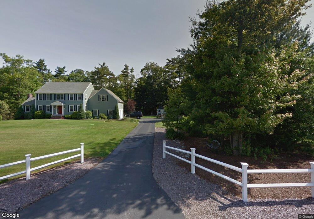
194 Independence Ave Hanson, MA 02341
Estimated Value: $1,145,434 - $1,639,000
5
Beds
5
Baths
5,203
Sq Ft
$254/Sq Ft
Est. Value
About This Home
This home is located at 194 Independence Ave, Hanson, MA 02341 and is currently estimated at $1,321,109, approximately $253 per square foot. 194 Independence Ave is a home located in Plymouth County.
Ownership History
Date
Name
Owned For
Owner Type
Purchase Details
Closed on
Jun 11, 2014
Sold by
Donovan Mark S and Donovan Lorraine G
Bought by
Dellechiaie Julie L and Dellechiaie Bruce J
Current Estimated Value
Home Financials for this Owner
Home Financials are based on the most recent Mortgage that was taken out on this home.
Original Mortgage
$240,000
Outstanding Balance
$75,053
Interest Rate
4.27%
Mortgage Type
New Conventional
Estimated Equity
$1,246,056
Purchase Details
Closed on
Aug 26, 2002
Sold by
Peck John A
Bought by
Donovan Mark S and Donovan Lorraine G
Create a Home Valuation Report for This Property
The Home Valuation Report is an in-depth analysis detailing your home's value as well as a comparison with similar homes in the area
Home Values in the Area
Average Home Value in this Area
Purchase History
| Date | Buyer | Sale Price | Title Company |
|---|---|---|---|
| Dellechiaie Julie L | $650,000 | -- | |
| Donovan Mark S | $5,000 | -- |
Source: Public Records
Mortgage History
| Date | Status | Borrower | Loan Amount |
|---|---|---|---|
| Open | Dellechiaie Julie L | $240,000 | |
| Previous Owner | Donovan Mark S | $348,000 | |
| Previous Owner | Donovan Mark S | $417,000 |
Source: Public Records
Tax History
| Year | Tax Paid | Tax Assessment Tax Assessment Total Assessment is a certain percentage of the fair market value that is determined by local assessors to be the total taxable value of land and additions on the property. | Land | Improvement |
|---|---|---|---|---|
| 2025 | $15,018 | $1,122,400 | $203,300 | $919,100 |
| 2024 | $14,734 | $1,101,200 | $197,400 | $903,800 |
| 2023 | $14,123 | $996,000 | $197,400 | $798,600 |
| 2022 | $13,807 | $915,000 | $179,400 | $735,600 |
| 2021 | $12,846 | $850,700 | $172,600 | $678,100 |
| 2020 | $12,682 | $830,500 | $166,700 | $663,800 |
| 2019 | $12,707 | $818,200 | $178,300 | $639,900 |
| 2018 | $12,579 | $794,600 | $171,400 | $623,200 |
| 2017 | $12,217 | $764,500 | $163,200 | $601,300 |
| 2016 | $12,333 | $745,200 | $163,200 | $582,000 |
Source: Public Records
Map
Nearby Homes
- Lot 6 Way
- 161 Winter St Unit 11
- 84 Liberty St
- Lot 5 Princeton Way
- 26 Stonebridge Dr
- 168 Spring St
- 80 Phillips St
- 72 Phillips St
- 724 Whitman St
- 134 Crescent St
- 1054 Main St
- 139 Fairwood Dr
- 23 Live Oak Way
- 26 Franklin St
- 126-130 Franklin St
- 430 Brook Bend Rd
- 22 Howland Trail Unit 34
- 17 Hayford Trail Unit 12
- 7 Hayford Trail Unit 12
- 5 Hayford Trail Unit 11
- 142 Independence Ave
- 120 Independence Ave
- 378 County Rd
- 166 Independence Ave
- 370 County Rd
- 83 Constitution Way
- 51 Constitution Way
- 104 Independence Ave
- 384 County Rd
- 352 County Rd
- 380 County Rd
- 153 Independence Ave
- 408 County Rd
- 111 Independence Ave
- 171 Independence Ave
- 22 Constitution Way
- 409 County Rd
- 381 County Rd
- 48 Constitution Way
- 0 County Rd
Your Personal Tour Guide
Ask me questions while you tour the home.