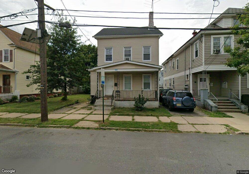
194 Powers St New Brunswick, NJ 08901
Estimated Value: $435,000 - $620,221
--
Bed
--
Bath
1,863
Sq Ft
$280/Sq Ft
Est. Value
About This Home
This home is located at 194 Powers St, New Brunswick, NJ 08901 and is currently estimated at $520,805, approximately $279 per square foot. 194 Powers St is a home located in Middlesex County with nearby schools including New Brunswick High School, Central Jersey College Prep Charter School, and St. Mary of Mount Virgin School.
Ownership History
Date
Name
Owned For
Owner Type
Purchase Details
Closed on
Jan 21, 2020
Sold by
Kakar Neeti
Bought by
194 Power Street Llc
Current Estimated Value
Purchase Details
Closed on
Mar 25, 2016
Sold by
Pilot Auto Sales Inc
Bought by
Kakar Neeti
Home Financials for this Owner
Home Financials are based on the most recent Mortgage that was taken out on this home.
Original Mortgage
$90,000
Interest Rate
4.02%
Mortgage Type
Purchase Money Mortgage
Purchase Details
Closed on
Jan 29, 2016
Sold by
Deluca Samuel A and De Luca Carole M
Bought by
Pilot Auto Sales Inc
Home Financials for this Owner
Home Financials are based on the most recent Mortgage that was taken out on this home.
Original Mortgage
$90,000
Interest Rate
4.02%
Mortgage Type
Purchase Money Mortgage
Purchase Details
Closed on
Jul 18, 1995
Sold by
Costa Antoinette
Bought by
Deluca Samuel
Create a Home Valuation Report for This Property
The Home Valuation Report is an in-depth analysis detailing your home's value as well as a comparison with similar homes in the area
Home Values in the Area
Average Home Value in this Area
Purchase History
| Date | Buyer | Sale Price | Title Company |
|---|---|---|---|
| 194 Power Street Llc | -- | Old Republic Natl Ttl Ins Co | |
| Kakar Neeti | $105,000 | Old Republic Natl Title Ins | |
| Pilot Auto Sales Inc | $90,000 | First American Title | |
| Deluca Samuel | $90,000 | -- |
Source: Public Records
Mortgage History
| Date | Status | Borrower | Loan Amount |
|---|---|---|---|
| Previous Owner | Pilot Auto Sales Inc | $90,000 |
Source: Public Records
Tax History Compared to Growth
Tax History
| Year | Tax Paid | Tax Assessment Tax Assessment Total Assessment is a certain percentage of the fair market value that is determined by local assessors to be the total taxable value of land and additions on the property. | Land | Improvement |
|---|---|---|---|---|
| 2025 | $7,011 | $267,700 | $138,500 | $129,200 |
| 2024 | $6,808 | $267,700 | $138,500 | $129,200 |
| 2023 | $6,808 | $267,700 | $138,500 | $129,200 |
| 2022 | $6,663 | $267,700 | $138,500 | $129,200 |
| 2021 | $6,636 | $267,700 | $138,500 | $129,200 |
| 2020 | $6,612 | $267,700 | $138,500 | $129,200 |
| 2019 | $6,486 | $267,700 | $138,500 | $129,200 |
| 2018 | $6,339 | $267,700 | $138,500 | $129,200 |
| 2017 | $6,088 | $267,700 | $138,500 | $129,200 |
| 2016 | $5,332 | $90,900 | $40,100 | $50,800 |
| 2015 | $5,205 | $90,900 | $40,100 | $50,800 |
| 2014 | $5,112 | $90,900 | $40,100 | $50,800 |
Source: Public Records
Map
Nearby Homes
- 158 Lee Ave
- 200 Talmadge St
- 122 Lawrence St Unit 26
- 184 Lawrence St
- 201 Fulton St
- 105 N Talmadge St
- 95 Renaissance Ln
- 11 Edgeworth Place
- 128 Remsen Ave Unit A
- 128A Remsen Ave
- 14 Edgeworth Place
- 122B Remsen Ave Unit A
- 122A Remsen Ave Unit A
- 1224 Dogwood Ct
- 294 Howard St
- 1234 Dogwood Ct
- 216 Handy St
- 130 Joyce Kilmer Ave
- 340 Livingston Ave
- 163 Livingston Ave