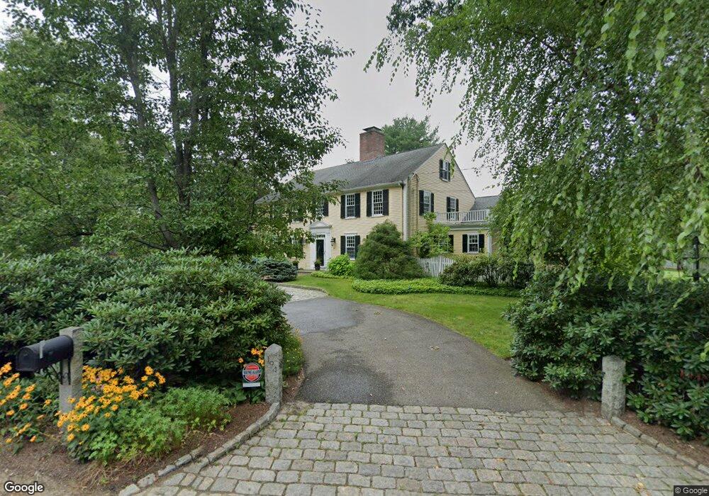
194 Simon Willard Rd Concord, MA 01742
Estimated Value: $3,405,000 - $5,197,000
6
Beds
5
Baths
5,290
Sq Ft
$824/Sq Ft
Est. Value
About This Home
This home is located at 194 Simon Willard Rd, Concord, MA 01742 and is currently estimated at $4,358,919, approximately $823 per square foot. 194 Simon Willard Rd is a home located in Middlesex County with nearby schools including Willard School, Concord Middle School, and Concord Carlisle High School.
Ownership History
Date
Name
Owned For
Owner Type
Purchase Details
Closed on
Dec 8, 2021
Sold by
Ann S Webster T
Bought by
Murdough Thomas G and Tolis-Murdough Tina
Current Estimated Value
Purchase Details
Closed on
Oct 26, 2015
Sold by
Webster Ann S
Bought by
Ann S Webster T
Purchase Details
Closed on
Oct 25, 2002
Sold by
Barrett Charles W and Barrett Jane M
Bought by
Webster Ann H
Create a Home Valuation Report for This Property
The Home Valuation Report is an in-depth analysis detailing your home's value as well as a comparison with similar homes in the area
Home Values in the Area
Average Home Value in this Area
Purchase History
| Date | Buyer | Sale Price | Title Company |
|---|---|---|---|
| Murdough Thomas G | $3,950,000 | None Available | |
| Ann S Webster T | -- | -- | |
| Webster Ann H | $3,075,000 | -- |
Source: Public Records
Tax History
| Year | Tax Paid | Tax Assessment Tax Assessment Total Assessment is a certain percentage of the fair market value that is determined by local assessors to be the total taxable value of land and additions on the property. | Land | Improvement |
|---|---|---|---|---|
| 2025 | $473 | $3,566,000 | $1,655,500 | $1,910,500 |
| 2024 | $46,489 | $3,540,700 | $1,655,500 | $1,885,200 |
| 2023 | $38,117 | $2,941,100 | $1,434,200 | $1,506,900 |
| 2022 | $36,289 | $2,458,600 | $1,063,200 | $1,395,400 |
| 2021 | $36,757 | $2,497,100 | $1,149,400 | $1,347,700 |
| 2020 | $36,915 | $2,594,200 | $1,206,900 | $1,387,300 |
| 2019 | $34,886 | $2,458,500 | $1,171,600 | $1,286,900 |
| 2018 | $34,889 | $2,441,500 | $1,142,700 | $1,298,800 |
| 2017 | $33,236 | $2,362,200 | $1,063,400 | $1,298,800 |
| 2016 | $33,061 | $2,375,100 | $1,063,400 | $1,311,700 |
| 2015 | $31,602 | $2,211,500 | $1,022,700 | $1,188,800 |
Source: Public Records
Map
Nearby Homes
- 244 Musterfield Rd
- 29 Willard Common
- 49 Willard Common
- 315 Musketaquid Rd
- 106 Elm St
- 101 Adams Rd
- 1 Baker Ave
- 265 Elsinore St
- 22 Belknap Ct
- 32 Thoreau St Unit 32
- 34 Thoreau St Unit 34
- 735 Lowell Rd Lot 1 Land
- 735 Lowell Rd
- 46 Sudbury Rd
- 150 Hubbard St Unit B
- 79-81 Assabet Ave
- 16 Concord Greene Unit 5
- 55 Staffordshire Ln Unit B
- 21 Concord Greene Unit 8
- 143 Everett St
- 105 Musterfield Rd
- 199 Simon Willard Rd
- 175 Simon Willard Rd
- 175 Simon Willard Rd
- 134 Musterfield Rd
- 158 Simon Willard Rd
- 75 Musterfield Rd
- 153 Simon Willard Rd
- 102 Musterfield Rd
- 191 Musterfield Rd
- 18 Musterfield Rod Lot18a
- 55 Musterfield Rd
- 80 Musterfield Rd
- 313 Simon Willard Rd
- 196 Musterfield Rd
- 256 Simon Willard Rd
- 263 Simon Willard Rd
- 65 Attawan Rd
- 74 Musterfield Rd
- 17 Musterfield Rd
Your Personal Tour Guide
Ask me questions while you tour the home.