Estimated Value: $191,205 - $256,000
3
Beds
1
Bath
1,896
Sq Ft
$116/Sq Ft
Est. Value
About This Home
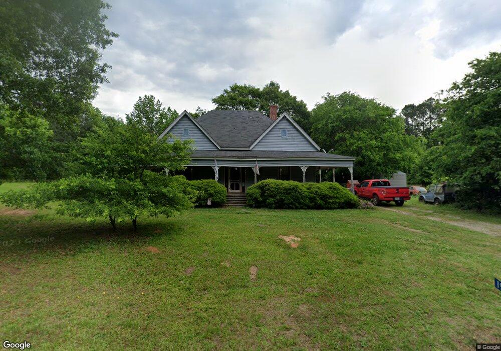
This home is located at 1940 Bartram Trace Rd, Rayle, GA 30660 and is currently estimated at $220,801, approximately $116 per square foot. 1940 Bartram Trace Rd is a home located in Wilkes County with nearby schools including Washington-Wilkes Elementary School, Washington-Wilkes Primary School, and Washington-Wilkes Middle School.
Ownership History
Date
Name
Owned For
Owner Type
Purchase Details
Closed on
Feb 14, 1997
Sold by
Beasley Sullivan L
Bought by
Klaus Tommy
Current Estimated Value
Purchase Details
Closed on
Mar 1, 1989
Bought by
Beasley Sullivan L
Purchase Details
Closed on
Apr 1, 1982
Purchase Details
Closed on
Feb 1, 1982
Create a Home Valuation Report for This Property
The Home Valuation Report is an in-depth analysis detailing your home's value as well as a comparison with similar homes in the area
Purchase History
| Date | Buyer | Sale Price | Title Company |
|---|---|---|---|
| Klaus Tommy | $75,000 | -- | |
| Beasley Sullivan L | $51,500 | -- | |
| -- | $12,000 | -- | |
| -- | $8,000 | -- |
Source: Public Records
Tax History
| Year | Tax Paid | Tax Assessment Tax Assessment Total Assessment is a certain percentage of the fair market value that is determined by local assessors to be the total taxable value of land and additions on the property. | Land | Improvement |
|---|---|---|---|---|
| 2025 | $1,074 | $39,754 | $5,156 | $34,598 |
| 2024 | $1,092 | $39,754 | $5,156 | $34,598 |
| 2023 | $1,075 | $39,754 | $5,156 | $34,598 |
| 2022 | $1,075 | $39,754 | $5,156 | $34,598 |
| 2021 | $1,100 | $39,754 | $5,156 | $34,598 |
| 2020 | $1,120 | $39,754 | $5,156 | $34,598 |
| 2019 | $1,129 | $39,754 | $5,156 | $34,598 |
| 2018 | $1,154 | $39,754 | $5,156 | $34,598 |
| 2017 | $1,154 | $39,754 | $5,156 | $34,598 |
| 2016 | $1,091 | $39,754 | $5,156 | $34,598 |
| 2015 | -- | $5,156 | $5,156 | $34,598 |
| 2014 | -- | $39,753 | $5,156 | $34,598 |
| 2013 | -- | $39,753 | $5,155 | $34,597 |
Source: Public Records
Map
Nearby Homes
- 0 Bartram Trace Rd
- 0 Bartram Trace Rd Unit 10677883
- 0 Thaxton Rd Unit 10696641
- 5111 Greensboro Rd
- 0 Quaker Springs Rd Unit 10691164
- 2242 Crawfordville Rd
- 310 Philomath Woodville Rd
- 2514 Greensboro Rd
- 0 Silas Mercer Rd NE Unit 10364766
- 1044 Sardis Rd
- 732 Hilliard Station Rd
- 3445 Silas Mercer Rd NE
- 900 Center Hill Rd
- 0 Saggus Rd Unit 10580223
- 520 Jackson St
- 403 Jackson St
- 402 Peachtree St
- 203 Peter St
- 0 Alabama St Unit CL350624
- 0 Alabama St Unit 10702112
Your Personal Tour Guide
Ask me questions while you tour the home.