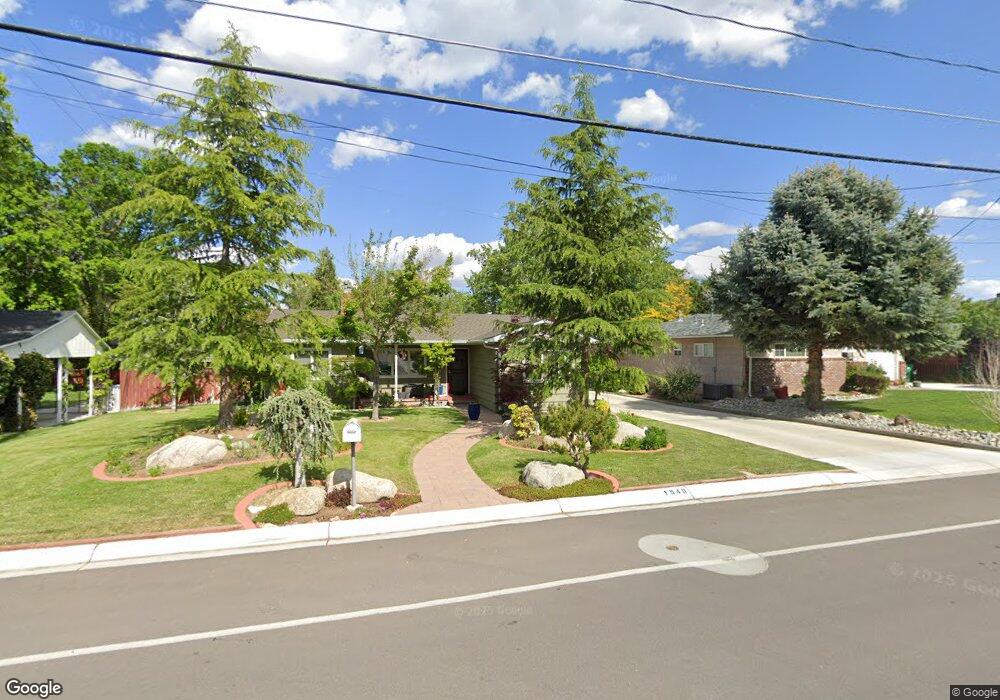
1940 Watt St Reno, NV 89509
Virginia Lake NeighborhoodEstimated Value: $594,760 - $625,000
3
Beds
1
Bath
1,184
Sq Ft
$517/Sq Ft
Est. Value
About This Home
This home is located at 1940 Watt St, Reno, NV 89509 and is currently estimated at $612,190, approximately $517 per square foot. 1940 Watt St is a home located in Washoe County with nearby schools including Jessie Beck Elementary School, Darrell C Swope Middle School, and Reno High School.
Ownership History
Date
Name
Owned For
Owner Type
Purchase Details
Closed on
Feb 6, 2025
Sold by
Churchfield Kimberley S and Churchfield Steven
Bought by
Churchfield Family 2025 Trust and Churchfield
Current Estimated Value
Purchase Details
Closed on
Nov 21, 1995
Sold by
Churchfield Steven and Churchfield Kimberley
Bought by
Churchfield Steven and Churchfield Kimberley D
Home Financials for this Owner
Home Financials are based on the most recent Mortgage that was taken out on this home.
Original Mortgage
$50,000
Interest Rate
7.58%
Create a Home Valuation Report for This Property
The Home Valuation Report is an in-depth analysis detailing your home's value as well as a comparison with similar homes in the area
Home Values in the Area
Average Home Value in this Area
Purchase History
| Date | Buyer | Sale Price | Title Company |
|---|---|---|---|
| Churchfield Family 2025 Trust | -- | None Listed On Document | |
| Churchfield Steven | -- | Stewart Title |
Source: Public Records
Mortgage History
| Date | Status | Borrower | Loan Amount |
|---|---|---|---|
| Previous Owner | Churchfield Steven | $50,000 |
Source: Public Records
Tax History Compared to Growth
Tax History
| Year | Tax Paid | Tax Assessment Tax Assessment Total Assessment is a certain percentage of the fair market value that is determined by local assessors to be the total taxable value of land and additions on the property. | Land | Improvement |
|---|---|---|---|---|
| 2025 | $999 | $77,763 | $56,420 | $21,343 |
| 2024 | $999 | $75,327 | $54,250 | $21,077 |
| 2023 | $971 | $68,935 | $49,455 | $19,480 |
| 2022 | $944 | $57,799 | $42,070 | $15,729 |
| 2021 | $918 | $52,141 | $36,750 | $15,391 |
| 2020 | $889 | $51,863 | $36,750 | $15,113 |
| 2019 | $863 | $47,551 | $33,250 | $14,301 |
| 2018 | $836 | $39,975 | $26,250 | $13,725 |
| 2017 | $815 | $32,640 | $19,285 | $13,355 |
| 2016 | $794 | $31,438 | $18,095 | $13,343 |
| 2015 | $213 | $29,138 | $15,925 | $13,213 |
| 2014 | $770 | $26,155 | $13,615 | $12,540 |
| 2013 | -- | $20,925 | $8,995 | $11,930 |
Source: Public Records
Map
Nearby Homes
- 230 Glenmanor Dr
- 395 Hillcrest Dr
- 421 Glenmanor Dr
- 2040 Alamo Square Way
- 2020 Alamo Square Way
- 2180 Alamo Square Way
- 225 Gramercy Ln
- 2091 S Virginia St
- 265 Lafayette Ln
- 1633 Knox Ave
- 2265 Grosvenor Park Place
- 2330 Sunrise Dr
- 43 Ardmore Dr
- 2450 Lymbery St Unit 228
- 2450 Lymbery St Unit 105
- 2450 Lymbery St Unit 113
- 2450 Lymbery St Unit 107
- 2450 Lymbery St Unit 230
- 206 Mount Rose St
- 320 Mount Rose St
- 1924 Watt St
- 1980 Watt St
- 275 Bonnie Briar Place
- 1918 Watt St
- 255 Bonnie Briar Place
- 295 Bonnie Briar Place
- 278 Hillcrest Dr
- 1912 Watt St
- 249 Bonnie Briar Place
- 1902 Watt St
- 301 Sunset Dr
- 2005 Watt St
- 280 Hillcrest Dr
- 245 Bonnie Briar Place
- 1929 Watt St
- 270 Hillcrest Dr
- 320 Sunset Dr
- 2000 Watt St
- 2009 Watt St
- 233 Bonnie Briar Place