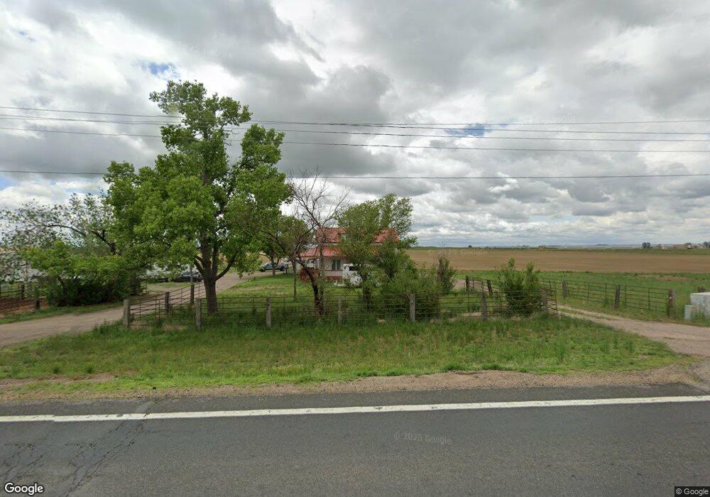
19406 Highway 52 Fort Lupton, CO 80621
Estimated Value: $598,000 - $975,000
3
Beds
1
Bath
1,710
Sq Ft
$437/Sq Ft
Est. Value
About This Home
This home is located at 19406 Highway 52, Fort Lupton, CO 80621 and is currently estimated at $747,867, approximately $437 per square foot. 19406 Highway 52 is a home located in Weld County with nearby schools including Weld Central Senior High School.
Ownership History
Date
Name
Owned For
Owner Type
Purchase Details
Closed on
Mar 31, 2023
Sold by
Ritchey Grant A
Bought by
Ritchey Land Company Llc
Current Estimated Value
Purchase Details
Closed on
Dec 19, 2022
Sold by
Ritchey David Wesley
Bought by
Ritchey Stacie
Purchase Details
Closed on
Dec 31, 2021
Sold by
Ritchey Craig E and Ritchey Mary C
Bought by
Ritchey Grant A and Ritchey Dawn D
Purchase Details
Closed on
Apr 14, 2006
Sold by
Ritchey Norma Jean
Bought by
Ritchey Grant A and Ritchey Dawn D
Purchase Details
Closed on
Dec 6, 2002
Sold by
Ritchey Clinton D
Bought by
Ritchey Norma Jean
Create a Home Valuation Report for This Property
The Home Valuation Report is an in-depth analysis detailing your home's value as well as a comparison with similar homes in the area
Home Values in the Area
Average Home Value in this Area
Purchase History
| Date | Buyer | Sale Price | Title Company |
|---|---|---|---|
| Ritchey Land Company Llc | -- | -- | |
| Ritchey Grant A | -- | -- | |
| Ritchey Stacie | -- | -- | |
| Ritchey Grant A | $575,000 | Heritage Title Co | |
| Ritchey Land Company Llc | $350,000 | None Listed On Document | |
| Ritchey Grant A | $365,000 | Security Title | |
| Ritchey Norma Jean | -- | -- |
Source: Public Records
Tax History Compared to Growth
Tax History
| Year | Tax Paid | Tax Assessment Tax Assessment Total Assessment is a certain percentage of the fair market value that is determined by local assessors to be the total taxable value of land and additions on the property. | Land | Improvement |
|---|---|---|---|---|
| 2025 | $1,926 | $34,980 | $6,110 | $28,870 |
| 2024 | $1,926 | $34,980 | $6,110 | $28,870 |
| 2023 | $1,807 | $40,200 | $6,220 | $33,980 |
| 2022 | $1,582 | $29,610 | $6,310 | $23,300 |
| 2021 | $1,751 | $31,010 | $6,930 | $24,080 |
| 2020 | $1,622 | $30,390 | $6,990 | $23,400 |
| 2019 | $1,706 | $30,390 | $6,990 | $23,400 |
| 2018 | $1,440 | $24,850 | $8,460 | $16,390 |
| 2017 | $1,357 | $24,850 | $8,460 | $16,390 |
| 2016 | $1,307 | $23,640 | $7,490 | $16,150 |
| 2015 | $1,071 | $23,640 | $7,490 | $16,150 |
| 2014 | $747 | $16,190 | $5,850 | $10,340 |
Source: Public Records
Map
Nearby Homes
- 17643 Clara Lee St
- 4022 Sunrise Ln
- 11 Sunset Ct
- 17294 Highway 52
- 6000 County Road 43 1 2
- 508 Hickory St
- 141 Main St
- 4511 Meadow Lark Rd
- 218 Grape St Unit 29
- 218 Grape St Unit 28
- 218 Grape St Unit 1
- 218 Grape St Unit 3
- 4806 Meadowlark Rd
- 220 Dawn Dr
- 21350 County Road 10
- 608 Cedar St
- 215 Dawn Dr
- 240 Buckboard Dr
- 210 Buckboard Dr
- 250 Buckboard Dr