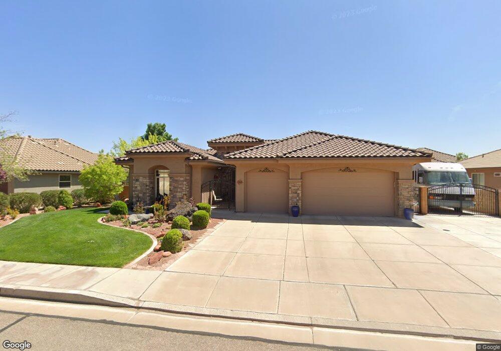
1941 W 470 N Unit 34 Saint George, UT 84770
Estimated Value: $560,550 - $649,000
3
Beds
3
Baths
2,134
Sq Ft
$286/Sq Ft
Est. Value
About This Home
This home is located at 1941 W 470 N Unit 34, Saint George, UT 84770 and is currently estimated at $609,888, approximately $285 per square foot. 1941 W 470 N Unit 34 is a home located in Washington County with nearby schools including Sunset School, Snow Canyon Middle School, and Lava Ridge Intermediate School.
Ownership History
Date
Name
Owned For
Owner Type
Purchase Details
Closed on
Jun 16, 2022
Sold by
Harrison Anderson Thomas
Bought by
Anderson Family Trust
Current Estimated Value
Purchase Details
Closed on
Dec 13, 2019
Sold by
Hansen Blaine L and Blaine L Hansen Living Trust
Bought by
Anderson Thomas Harrison and Anderson Chadloy Ann
Home Financials for this Owner
Home Financials are based on the most recent Mortgage that was taken out on this home.
Original Mortgage
$400,000
Interest Rate
3.7%
Mortgage Type
VA
Purchase Details
Closed on
Jun 10, 2013
Sold by
Stewart Jesse Ford and Stewart Chelsea T
Bought by
Hansen Blaine L and Blaine L Hansen Living Trust
Purchase Details
Closed on
Jan 18, 2008
Sold by
Twin Creeks Properties Llc
Bought by
Stewart Jesse Ford and Stewart Chelsea T
Create a Home Valuation Report for This Property
The Home Valuation Report is an in-depth analysis detailing your home's value as well as a comparison with similar homes in the area
Home Values in the Area
Average Home Value in this Area
Purchase History
| Date | Buyer | Sale Price | Title Company |
|---|---|---|---|
| Anderson Family Trust | -- | None Listed On Document | |
| Anderson Thomas Harrison | -- | Mountain View Ttl St George | |
| Hansen Blaine L | -- | Southern Utah Title | |
| Stewart Jesse Ford | -- | Southern Utah Title Co |
Source: Public Records
Mortgage History
| Date | Status | Borrower | Loan Amount |
|---|---|---|---|
| Previous Owner | Anderson Thomas Harrison | $400,000 |
Source: Public Records
Tax History Compared to Growth
Tax History
| Year | Tax Paid | Tax Assessment Tax Assessment Total Assessment is a certain percentage of the fair market value that is determined by local assessors to be the total taxable value of land and additions on the property. | Land | Improvement |
|---|---|---|---|---|
| 2025 | $2,119 | $311,190 | $82,500 | $228,690 |
| 2023 | $2,280 | $340,615 | $68,750 | $271,865 |
| 2022 | $2,391 | $335,995 | $63,250 | $272,745 |
| 2021 | $1,236 | $409,300 | $85,000 | $324,300 |
| 2020 | $1,773 | $349,900 | $70,000 | $279,900 |
| 2019 | $1,640 | $316,100 | $70,000 | $246,100 |
| 2018 | $1,811 | $180,290 | $0 | $0 |
| 2017 | $1,837 | $177,540 | $0 | $0 |
| 2016 | $1,797 | $160,600 | $0 | $0 |
| 2015 | $1,814 | $155,540 | $0 | $0 |
| 2014 | $1,829 | $157,795 | $0 | $0 |
Source: Public Records
Map
Nearby Homes
- 1950 W 470 St N
- 414 Northstar Dr
- 1732 W 540 N Unit 13
- 1732 W 540 N Unit 120
- 1732 W 540 N Unit 92
- 1732 W 540 N Unit 161
- 1732 W 540 N Unit 68
- 1732 W 540 N Unit 17
- 1735 W 540 N Unit 1203
- 1735 W 540 N Unit 1202
- 565 N Moonglow Place
- 340 N Country Ln Unit 66
- 340 N Country Ln Unit 27
- 665 N Dusk Dr
- 271 N Country Ln Unit 60
- 271 N Country Ln Unit B14
- 225 N Country Ln Unit 111
- 225 N Country Ln Unit 104
- 225 N Country Ln Unit 5
- 265 N Dixie Dr Unit 44
- 1941 W 470 N
- 1955 W 470 St N
- 1953 W 470 St N
- 1936 W 430 N
- 1927 W 470 N
- 1936 430 Cir N
- 1950 W 430 N
- 1938 W 470 N
- 1950 W 430 North Cir
- 1936 W 430 North Cir
- 499 N 1923 Way
- 458 N 1910 St W
- 1969 W 470 N
- 1969 W 470 N Unit 36
- 1924 W 470 N
- 472 N 1910 St W
- 1964 W 430 North Cir
- 1939 W 430 North Cir
- 1966 W 470 N
- 1939 W 430 N