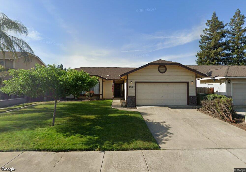
1942 Porter Way Turlock, CA 95380
Estimated Value: $355,000 - $516,000
3
Beds
2
Baths
1,630
Sq Ft
$274/Sq Ft
Est. Value
About This Home
This home is located at 1942 Porter Way, Turlock, CA 95380 and is currently estimated at $446,913, approximately $274 per square foot. 1942 Porter Way is a home located in Stanislaus County with nearby schools including Crowell Elementary School, Marvin A. Dutcher Middle School, and Turlock Junior High School.
Ownership History
Date
Name
Owned For
Owner Type
Purchase Details
Closed on
Feb 15, 2002
Sold by
Bento Antonio R and Bento Maria E
Bought by
Bento Antonio R and Bento Maria E
Current Estimated Value
Purchase Details
Closed on
Dec 18, 2000
Sold by
Peterson Robert Dennis and Joyce Marica
Bought by
Bento Antonio R and Bento Maria E
Home Financials for this Owner
Home Financials are based on the most recent Mortgage that was taken out on this home.
Original Mortgage
$49,900
Interest Rate
7.71%
Purchase Details
Closed on
Nov 17, 1993
Sold by
Peterson Joyce Marica and Turner Joyce M
Bought by
Peterson Robert Dennis and Peterson Joyce Marica
Home Financials for this Owner
Home Financials are based on the most recent Mortgage that was taken out on this home.
Original Mortgage
$76,000
Interest Rate
6.88%
Create a Home Valuation Report for This Property
The Home Valuation Report is an in-depth analysis detailing your home's value as well as a comparison with similar homes in the area
Purchase History
| Date | Buyer | Sale Price | Title Company |
|---|---|---|---|
| Bento Antonio R | -- | -- | |
| Bento Antonio R | $150,000 | North American Title Co | |
| Peterson Robert Dennis | -- | Chicago Title Company |
Source: Public Records
Mortgage History
| Date | Status | Borrower | Loan Amount |
|---|---|---|---|
| Closed | Bento Antonio R | $49,900 | |
| Previous Owner | Peterson Robert Dennis | $76,000 |
Source: Public Records
Tax History
| Year | Tax Paid | Tax Assessment Tax Assessment Total Assessment is a certain percentage of the fair market value that is determined by local assessors to be the total taxable value of land and additions on the property. | Land | Improvement |
|---|---|---|---|---|
| 2025 | $2,447 | $226,002 | $45,192 | $180,810 |
| 2024 | $2,402 | $221,571 | $44,306 | $177,265 |
| 2023 | $2,399 | $217,228 | $43,438 | $173,790 |
| 2022 | $2,369 | $212,970 | $42,587 | $170,383 |
| 2021 | $2,334 | $208,795 | $41,752 | $167,043 |
| 2020 | $2,318 | $206,655 | $41,324 | $165,331 |
| 2019 | $2,280 | $202,604 | $40,514 | $162,090 |
| 2018 | $2,278 | $198,632 | $39,720 | $158,912 |
| 2017 | $2,225 | $194,739 | $38,942 | $155,797 |
| 2016 | $2,079 | $190,922 | $38,179 | $152,743 |
| 2015 | $2,062 | $188,055 | $37,606 | $150,449 |
| 2014 | $2,042 | $184,372 | $36,870 | $147,502 |
Source: Public Records
Map
Nearby Homes
- 200 N Tully Rd
- 500 N Tully Rd
- 2175 W Main St
- 3131 W Main St
- 1253 Magic Sands Way
- 1051 Hysell Ct
- 2230 Aspenwood Dr
- 2625 W Main St
- 2200 Chelsea Place
- 1095 Skyway Ct
- 250 Davis St
- 830 Flower St
- 1330 Dianne Dr
- 1400 N Tully Rd Unit 187
- 350 West Ave S
- 900 W Canal Dr Unit 100
- 900 W Canal Dr Unit 114
- 819 Julian St
- 531 Justin Dr
- 350 West Ave N
- 1922 Porter Way
- 1982 Porter Way
- 300 N Tully Rd
- 1983 Henry Way
- 1902 Porter Way
- 1963 Porter Way
- 1963 Henry Way
- 1983 Porter Way
- 1903 Porter Way
- 1943 Henry Way
- 1882 Porter Way
- 2003 Porter Way
- 1883 Porter Way
- 2000 Blush Ct
- 1923 Henry Way
- 2010 Blush Ct
- 1862 Porter Way
- 525 N Tully Rd
- 2030 Blush Ct
- 447 Asti Ct
Your Personal Tour Guide
Ask me questions while you tour the home.