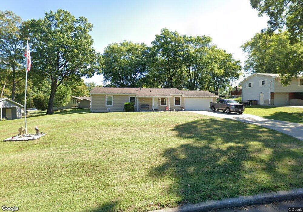
1942 Rampart St Cape Girardeau, MO 63701
Estimated Value: $192,311 - $238,000
4
Beds
2
Baths
1,300
Sq Ft
$166/Sq Ft
Est. Value
About This Home
This home is located at 1942 Rampart St, Cape Girardeau, MO 63701 and is currently estimated at $216,328, approximately $166 per square foot. 1942 Rampart St is a home located in Cape Girardeau County with nearby schools including Alma Schrader Elementary School, Central Middle School, and Central Junior High School.
Ownership History
Date
Name
Owned For
Owner Type
Purchase Details
Closed on
Aug 16, 2010
Sold by
Hanabarger Dennis E and Hanabarger Sarah
Bought by
Lusk Teresa F and Lusk Danny A
Current Estimated Value
Home Financials for this Owner
Home Financials are based on the most recent Mortgage that was taken out on this home.
Original Mortgage
$86,830
Outstanding Balance
$57,316
Interest Rate
4.51%
Mortgage Type
FHA
Estimated Equity
$159,012
Purchase Details
Closed on
Jul 26, 2006
Sold by
Matvy Michael J
Bought by
Hanabarger Dennis E and Hanabarger Sarah
Home Financials for this Owner
Home Financials are based on the most recent Mortgage that was taken out on this home.
Original Mortgage
$72,000
Interest Rate
6.78%
Mortgage Type
New Conventional
Purchase Details
Closed on
Jun 24, 2005
Sold by
Matvy Linda G
Bought by
Matvy Michael J
Create a Home Valuation Report for This Property
The Home Valuation Report is an in-depth analysis detailing your home's value as well as a comparison with similar homes in the area
Home Values in the Area
Average Home Value in this Area
Purchase History
| Date | Buyer | Sale Price | Title Company |
|---|---|---|---|
| Lusk Teresa F | -- | None Available | |
| Hanabarger Dennis E | -- | None Available | |
| Matvy Michael J | -- | None Available |
Source: Public Records
Mortgage History
| Date | Status | Borrower | Loan Amount |
|---|---|---|---|
| Open | Lusk Teresa F | $86,830 | |
| Previous Owner | Hanabarger Dennis E | $72,000 |
Source: Public Records
Tax History Compared to Growth
Tax History
| Year | Tax Paid | Tax Assessment Tax Assessment Total Assessment is a certain percentage of the fair market value that is determined by local assessors to be the total taxable value of land and additions on the property. | Land | Improvement |
|---|---|---|---|---|
| 2025 | $9 | $17,740 | $2,960 | $14,780 |
| 2024 | $9 | $16,900 | $2,820 | $14,080 |
| 2023 | $878 | $16,900 | $2,820 | $14,080 |
| 2022 | $810 | $15,580 | $2,600 | $12,980 |
| 2021 | $810 | $15,580 | $2,600 | $12,980 |
| 2020 | $812 | $15,580 | $2,600 | $12,980 |
| 2019 | $811 | $15,570 | $0 | $0 |
| 2018 | $809 | $15,570 | $0 | $0 |
| 2017 | $811 | $15,570 | $0 | $0 |
| 2016 | $808 | $15,570 | $0 | $0 |
| 2015 | $808 | $15,570 | $0 | $0 |
| 2014 | $813 | $15,570 | $0 | $0 |
Source: Public Records
Map
Nearby Homes
- 2520 Horseshoe Ridge
- 2137 Wood Hollow Ct
- 2519 Horseshoe Ridge
- 1966 Randol Ave
- 1705 Paul Revere Dr
- 2528 Palomino Dr
- 2415 Perryville Rd
- 2085 Derbyshire Ln
- 2206 Derbyshire Ln
- 1938 Westwood Dr
- 2550 Marvin St
- 1960 Briarwood Dr
- 2062 Concord Place
- 2412 Masters Dr
- 1623 Lexington Ave
- 1912 Perryville Rd
- 1608 Lexington Ave
- 1246 Marilyn Dr
- 1910 Sherwood Dr
- 2153 Esker Trail
- 1932 Rampart St
- 1952 Rampart St
- 1943 Rampart St
- 1943 Belleridge Pike
- 1953 Belleridge Pike
- 1931 Belleridge Pike
- 1953 Rampart St
- 1922 Rampart St
- 1923 Belleridge Pike
- 1923 Rampart St
- 1914 Rampart St
- 2135 Rampart St
- 1934 Belleridge Pike
- 1952 Belleridge Pike
- 1913 Belleridge
- 1932 Belleridge Pike
- 2139 Belleridge Pike
- 1913 Rampart St
- 1922 Belleridge Pike
- 2139 Rampart St