Estimated Value: $124,000 - $236,000
3
Beds
2
Baths
1,300
Sq Ft
$147/Sq Ft
Est. Value
About This Home
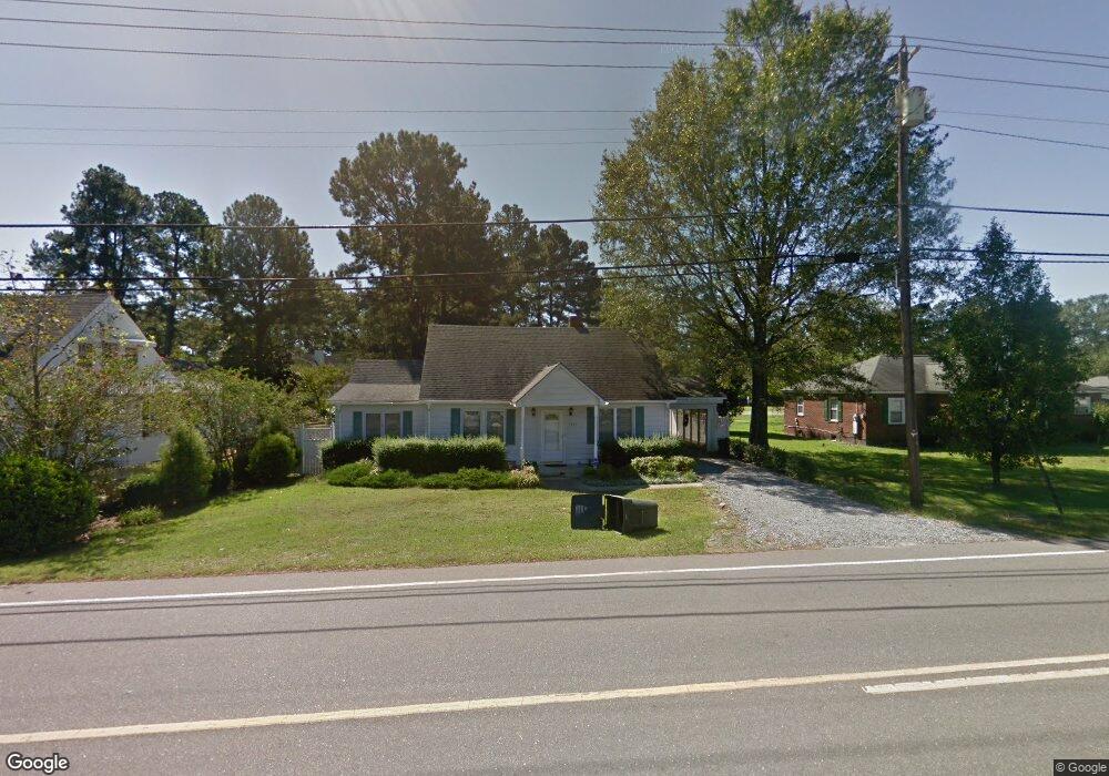
This home is located at 1942 Us Highway 70a E, Selma, NC 27576 and is currently estimated at $190,719, approximately $146 per square foot. 1942 Us Highway 70a E is a home with nearby schools including Pine Level Elementary School, North Johnston Middle School, and North Johnston High School.
Ownership History
Date
Name
Owned For
Owner Type
Purchase Details
Closed on
Apr 25, 2022
Sold by
Kirby Shannon and Kirby William
Bought by
Prior Sophie M
Current Estimated Value
Purchase Details
Closed on
Feb 25, 2022
Sold by
Kirby and William
Bought by
Prior Sophie M
Purchase Details
Closed on
Jul 12, 2019
Sold by
Pittman Peggy Carter
Bought by
Hohl Janice Faye and Pittman Peggy C
Purchase Details
Closed on
Apr 28, 2017
Sold by
Hohl Janice Faye and Pittman Peggy C
Bought by
Pittman Peggy Carter
Create a Home Valuation Report for This Property
The Home Valuation Report is an in-depth analysis detailing your home's value as well as a comparison with similar homes in the area
Home Values in the Area
Average Home Value in this Area
Purchase History
| Date | Buyer | Sale Price | Title Company |
|---|---|---|---|
| Prior Sophie M | -- | None Listed On Document | |
| Prior Sophie M | $100,000 | Nona Title | |
| Hohl Janice Faye | -- | None Available | |
| Pittman Peggy Carter | -- | None Available |
Source: Public Records
Tax History
| Year | Tax Paid | Tax Assessment Tax Assessment Total Assessment is a certain percentage of the fair market value that is determined by local assessors to be the total taxable value of land and additions on the property. | Land | Improvement |
|---|---|---|---|---|
| 2025 | $1,778 | $190,190 | $28,370 | $161,820 |
| 2024 | $772 | $65,410 | $18,910 | $46,500 |
| 2023 | $834 | $65,410 | $18,910 | $46,500 |
| 2022 | $811 | $65,410 | $18,910 | $46,500 |
| 2021 | $801 | $65,410 | $18,910 | $46,500 |
| 2020 | $808 | $65,410 | $18,910 | $46,500 |
| 2019 | $808 | $65,410 | $18,910 | $46,500 |
| 2018 | $699 | $55,730 | $18,910 | $36,820 |
| 2017 | $699 | $55,730 | $18,910 | $36,820 |
| 2016 | $699 | $55,730 | $18,910 | $36,820 |
| 2015 | $688 | $55,730 | $18,910 | $36,820 |
| 2014 | $688 | $55,730 | $18,910 | $36,820 |
Source: Public Records
Map
Nearby Homes
- 125 W Pine St
- 59 Jc Dr
- 0 Us Highway 70 A Unit 100543081
- 0 Us Highway 70 A
- 30 E Emily Gardens Dr Unit (Lot 90)
- 30 E Emily Gardens Dr
- 31 E Emily Gardens Dr Unit (Lot 85)
- 31 E Emily Gardens Dr
- 21 E Emily Gardens Dr
- 21 E Emily Gardens Dr Unit (Lot 84)
- 13 E Emily Gardens Dr
- 13 E Emily Gardens Dr Unit (Lot 83)
- 111 E Oak St
- 22 E Emily Gardens Dr
- 22 E Emily Gardens Dr Unit (Lot 91)
- 25 W Emily Gardens Dr
- 25 W Emily Gardens Dr Unit (Lot 58)
- 110 Oak St
- 63 W Emily Gardens Dr Unit (Lot 63)
- 63 W Emily Gardens Dr
- 0 U S 70 Alternate
- 1942 US 70a
- 115 Church St
- 1117 Davis Mill Rd
- 213 S Church St
- 102 N Peedin Ave
- 204 S Church St
- 210 S Peedin Ave
- 212 S Peedin Ave
- 0 S Peedin Ave
- 212 S Church St
- 113 W Blanche Street Extension
- 101 S Church St
- 217 S Church St
- 108 Starline Rd
- 114 Starling St
- 101 S Peedin Ave
- 1449 Us Hwy 70a
- 2094 Us Hwy 70a
- 1603 Us Hwy 70a
Your Personal Tour Guide
Ask me questions while you tour the home.