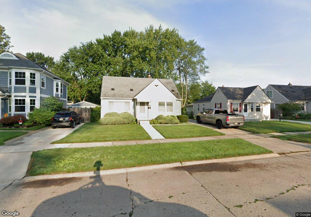
1943 Buckingham Ave Berkley, MI 48072
Estimated Value: $283,000 - $329,000
2
Beds
1
Bath
1,087
Sq Ft
$280/Sq Ft
Est. Value
About This Home
This home is located at 1943 Buckingham Ave, Berkley, MI 48072 and is currently estimated at $304,013, approximately $279 per square foot. 1943 Buckingham Ave is a home located in Oakland County with nearby schools including Angell Elementary School, Anderson Middle School, and Berkley High School.
Ownership History
Date
Name
Owned For
Owner Type
Purchase Details
Closed on
Oct 28, 2025
Sold by
Williamson William A and Williamson-Schimmel Nancy Ann
Bought by
Williamson William A and Williamson-Schimmel Nancy Ann
Current Estimated Value
Purchase Details
Closed on
Jun 27, 2017
Sold by
Williamson William A and Williamson Annabelle
Bought by
Williamson William A and Williamson Schimmel Nancy Ann
Create a Home Valuation Report for This Property
The Home Valuation Report is an in-depth analysis detailing your home's value as well as a comparison with similar homes in the area
Home Values in the Area
Average Home Value in this Area
Purchase History
| Date | Buyer | Sale Price | Title Company |
|---|---|---|---|
| Williamson William A | -- | None Listed On Document | |
| Williamson William A | -- | None Available |
Source: Public Records
Tax History Compared to Growth
Tax History
| Year | Tax Paid | Tax Assessment Tax Assessment Total Assessment is a certain percentage of the fair market value that is determined by local assessors to be the total taxable value of land and additions on the property. | Land | Improvement |
|---|---|---|---|---|
| 2024 | $2,630 | $128,820 | $0 | $0 |
| 2023 | $2,370 | $116,790 | $0 | $0 |
| 2022 | $2,369 | $107,210 | $0 | $0 |
| 2021 | $2,316 | $100,920 | $0 | $0 |
| 2020 | $2,215 | $95,700 | $0 | $0 |
| 2019 | $2,326 | $91,000 | $0 | $0 |
| 2018 | $2,224 | $85,060 | $0 | $0 |
| 2017 | $2,196 | $80,670 | $0 | $0 |
| 2016 | $2,216 | $74,980 | $0 | $0 |
| 2015 | -- | $68,430 | $0 | $0 |
| 2014 | -- | $61,790 | $0 | $0 |
| 2011 | -- | $59,040 | $0 | $0 |
Source: Public Records
Map
Nearby Homes
- 2085 Gardner Ave
- 1799 Phillips Ave
- 1888 Griffith Ave
- 14421 Labelle St
- 2863 Columbia Rd
- 14670 Talbot St
- 3325 Catalpa Dr
- 2519 Phillips Ave
- 14231 Borgman St
- 2907 Sunnyknoll Ave
- 2679 Columbia Rd
- 14710 Loretta Place
- 2112 Ellwood Ave
- 2756 Buckingham Ave
- 2678 Bacon Ave
- 26040 Marlowe Place
- 2783 Royal Ave
- 13680 Borgman St
- 2464 Greenfield Rd
- 2716 Thomas Ave
- 1951 Buckingham Ave
- 1927 Buckingham Ave
- 1975 Buckingham Ave
- 1911 Buckingham Ave
- 1960 Royal Ave
- 1944 Royal Ave
- 1991 Buckingham Ave Unit Bldg-Unit
- 1881 Buckingham Ave
- 1976 Royal Ave
- 1928 Royal Ave
- 1912 Royal Ave
- 1863 Buckingham Ave
- 1882 Royal Ave
- 1952 Buckingham Ave
- 1992 Royal Ave
- 1936 Buckingham Ave
- 1920 Buckingham Ave
- 1864 Royal Ave
- 1972 Buckingham Ave
- 1839 Buckingham Ave