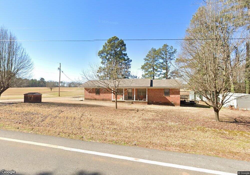
1943 Highway 53 S Gurdon, AR 71743
Estimated Value: $89,660 - $153,000
--
Bed
2
Baths
1,494
Sq Ft
$80/Sq Ft
Est. Value
About This Home
This home is located at 1943 Highway 53 S, Gurdon, AR 71743 and is currently estimated at $118,915, approximately $79 per square foot. 1943 Highway 53 S is a home located in Clark County with nearby schools including Gurdon Primary School, Cabe Middle School, and Gurdon High School.
Ownership History
Date
Name
Owned For
Owner Type
Purchase Details
Closed on
Mar 3, 2016
Bought by
Pritchard Bobby and Cohoon Ruth
Current Estimated Value
Purchase Details
Closed on
Feb 11, 2016
Bought by
Pritchard Bobby and Cohoon Ruth
Purchase Details
Closed on
Aug 24, 2001
Bought by
Pritchard Bobby and Cohoon Ruth
Purchase Details
Closed on
May 10, 2001
Bought by
Mckenzie Miles L
Purchase Details
Closed on
Aug 1, 1994
Bought by
Walters Roland and Walters Hazel
Create a Home Valuation Report for This Property
The Home Valuation Report is an in-depth analysis detailing your home's value as well as a comparison with similar homes in the area
Home Values in the Area
Average Home Value in this Area
Purchase History
| Date | Buyer | Sale Price | Title Company |
|---|---|---|---|
| Pritchard Bobby | -- | -- | |
| Pritchard Bobby | -- | -- | |
| Pritchard Bobby | $49,000 | -- | |
| Mckenzie Miles L | $35,000 | -- | |
| Walters Roland | $40,000 | -- |
Source: Public Records
Tax History Compared to Growth
Tax History
| Year | Tax Paid | Tax Assessment Tax Assessment Total Assessment is a certain percentage of the fair market value that is determined by local assessors to be the total taxable value of land and additions on the property. | Land | Improvement |
|---|---|---|---|---|
| 2024 | $148 | $12,930 | $300 | $12,630 |
| 2023 | $223 | $12,930 | $300 | $12,630 |
| 2022 | $557 | $12,930 | $300 | $12,630 |
| 2021 | $557 | $12,930 | $300 | $12,630 |
| 2020 | $557 | $12,930 | $300 | $12,630 |
| 2019 | $511 | $11,850 | $300 | $11,550 |
| 2018 | $155 | $11,850 | $300 | $11,550 |
| 2017 | $155 | $11,850 | $300 | $11,550 |
| 2016 | -- | $11,850 | $300 | $11,550 |
| 2015 | -- | $11,850 | $300 | $11,550 |
| 2014 | -- | $8,210 | $300 | $7,910 |
Source: Public Records
Map
Nearby Homes
- TBD Hwy 67
- 000 Kansas Rd
- TBD Kansas Rd
- 51 South St
- 110 S 10th St
- 326 Arkansas 53
- 0000 Arkansas 53
- 103 Stonegate Ct
- 109 N 7th St
- 58 Dodgen Rd
- 1795 Bowen Hill Rd
- 7104 Highway 67 S
- 313 W Miller St
- 0 Kansas Rd
- TBD Hwy 67 S
- 0 Beech Creek Rd
- 236 Lockie Rd
- 845 Stevenson Rd
- 652 Center Point
- 196 Stevenson Rd