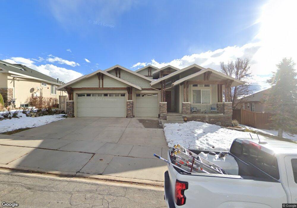
1944 E Longbranch Dr Draper, UT 84020
Estimated Value: $897,000 - $1,116,000
7
Beds
4
Baths
4,480
Sq Ft
$220/Sq Ft
Est. Value
About This Home
This home is located at 1944 E Longbranch Dr, Draper, UT 84020 and is currently estimated at $985,818, approximately $220 per square foot. 1944 E Longbranch Dr is a home located in Utah County with nearby schools including Ridgeline Elementary School, Timberline Middle School, and Lone Peak High School.
Ownership History
Date
Name
Owned For
Owner Type
Purchase Details
Closed on
Dec 17, 2025
Sold by
Baker Ryan
Bought by
Baker Ryan and Baker Jennifer Marie
Current Estimated Value
Home Financials for this Owner
Home Financials are based on the most recent Mortgage that was taken out on this home.
Original Mortgage
$231,000
Outstanding Balance
$230,560
Interest Rate
6.24%
Mortgage Type
Credit Line Revolving
Estimated Equity
$755,258
Purchase Details
Closed on
May 4, 2016
Sold by
Vanotten Steven Van and Vanotten Ravhel Van
Bought by
Baker Ryan
Purchase Details
Closed on
Oct 1, 2003
Sold by
Vanotten Steven D and Vanotten Rachel W
Bought by
Vanotten Steven and Vanotten Rachel
Home Financials for this Owner
Home Financials are based on the most recent Mortgage that was taken out on this home.
Original Mortgage
$259,800
Interest Rate
6.22%
Mortgage Type
Purchase Money Mortgage
Purchase Details
Closed on
Jun 4, 2002
Sold by
Richmond American Homes Of Utah Inc
Bought by
Vanotten Steven D and Vanotten Rachel W
Home Financials for this Owner
Home Financials are based on the most recent Mortgage that was taken out on this home.
Original Mortgage
$294,492
Interest Rate
6.83%
Create a Home Valuation Report for This Property
The Home Valuation Report is an in-depth analysis detailing your home's value as well as a comparison with similar homes in the area
Home Values in the Area
Average Home Value in this Area
Purchase History
| Date | Buyer | Sale Price | Title Company |
|---|---|---|---|
| Baker Ryan | -- | First American Title | |
| Baker Ryan | -- | Gateway Title Ins Agency Llc | |
| Vanotten Steven | -- | Pinnacle Title Co | |
| Vanotten Steven D | -- | First American Title Co |
Source: Public Records
Mortgage History
| Date | Status | Borrower | Loan Amount |
|---|---|---|---|
| Open | Baker Ryan | $231,000 | |
| Previous Owner | Vanotten Steven | $259,800 | |
| Previous Owner | Vanotten Steven D | $294,492 |
Source: Public Records
Tax History
| Year | Tax Paid | Tax Assessment Tax Assessment Total Assessment is a certain percentage of the fair market value that is determined by local assessors to be the total taxable value of land and additions on the property. | Land | Improvement |
|---|---|---|---|---|
| 2025 | $3,931 | $484,715 | -- | -- |
| 2024 | $3,931 | $412,115 | $0 | $0 |
| 2023 | $3,805 | $429,770 | $0 | $0 |
| 2022 | $3,763 | $414,645 | $0 | $0 |
| 2021 | $3,190 | $550,700 | $163,300 | $387,400 |
| 2020 | $3,072 | $518,000 | $130,600 | $387,400 |
| 2019 | $2,962 | $518,000 | $130,600 | $387,400 |
| 2018 | $2,964 | $492,100 | $121,100 | $371,000 |
| 2017 | $2,702 | $238,755 | $0 | $0 |
| 2016 | $2,441 | $202,180 | $0 | $0 |
| 2015 | $2,401 | $187,440 | $0 | $0 |
| 2014 | $2,254 | $183,920 | $0 | $0 |
Source: Public Records
Map
Nearby Homes
- 1871 E Vista Ridge Ct
- 1917 E Aspen Leaf Place
- 15219 Eagle Crest Dr Unit 141
- 14849 S Saddle Leaf Ct
- 1536 E Trail Crest Ct
- 2116 Falcon Ridge Dr
- 1468 E Trail Crest Ct
- 1492 E Meadow Bluff Ln Unit 48
- 14767 S Invergarry Ct
- 15193 S Eagle Crest Dr Unit 141
- 1463 Meadow Bluff Ln Unit 66
- 1459 E Meadow Bluff Ln
- 14948 S Springtime Rd
- 14798 S Glacial Peak Dr
- 14884 S Lone Birch Ln
- 14833 S Springtime Rd
- 2203 E Fair Winns Ln
- 15574 S Mercer Ct Unit 502
- 15724 Rolling Bluff Dr
- 14749 S Springtime Rd Unit 620
- 1944 Longbranch Dr
- 1938 Longbranch Dr
- 1952 E Longbranch Dr
- 1952 Longbranch Dr
- 1954 E Longbranch Dr
- 1954 Longbranch Dr
- 1932 Longbranch Dr
- 1939 E Longbrach Dr
- 1939 Longbranch Dr
- 1949 Longbranch Dr
- 1931 Longbranch Dr
- 1931 E Longbranch Dr
- 1953 Longbranch Dr
- 1953 E Longbranch Dr
- 1958 Longbranch Dr
- 1958 E Longbranch Dr
- 1922 Longbranch Dr
- 1919 Longbranch Dr
- 1919 E Longbranch Dr
- 1914 Longbranch Dr
Your Personal Tour Guide
Ask me questions while you tour the home.