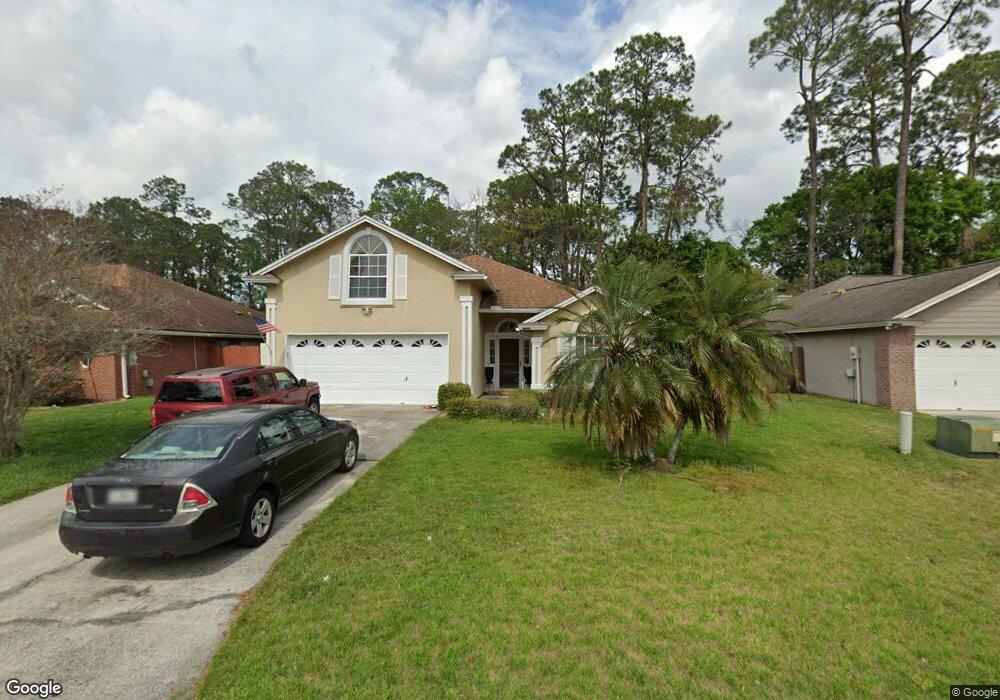
1944 Harbor Island Dr Fleming Island, FL 32003
Estimated Value: $362,907 - $411,000
5
Beds
3
Baths
2,126
Sq Ft
$182/Sq Ft
Est. Value
About This Home
This home is located at 1944 Harbor Island Dr, Fleming Island, FL 32003 and is currently estimated at $386,977, approximately $182 per square foot. 1944 Harbor Island Dr is a home located in Clay County with nearby schools including Robert M. Paterson Elementary School, Fleming Island High School, and Green Cove Springs Junior High School.
Ownership History
Date
Name
Owned For
Owner Type
Purchase Details
Closed on
Aug 4, 2011
Sold by
Perez Wendell and Dupuy Perez Maria
Bought by
Perez Wendell
Current Estimated Value
Purchase Details
Closed on
Jun 25, 2009
Sold by
Mains David A and Mains Barbara E
Bought by
Perez Wendell and Dupuy Perez Maria
Home Financials for this Owner
Home Financials are based on the most recent Mortgage that was taken out on this home.
Original Mortgage
$191,468
Interest Rate
4.79%
Mortgage Type
Purchase Money Mortgage
Purchase Details
Closed on
Mar 29, 2004
Sold by
Gallina Guy K and Gallina Jean Marie
Bought by
Mains David A and Mains Barbara E
Home Financials for this Owner
Home Financials are based on the most recent Mortgage that was taken out on this home.
Original Mortgage
$141,400
Interest Rate
4.12%
Mortgage Type
Purchase Money Mortgage
Create a Home Valuation Report for This Property
The Home Valuation Report is an in-depth analysis detailing your home's value as well as a comparison with similar homes in the area
Home Values in the Area
Average Home Value in this Area
Purchase History
| Date | Buyer | Sale Price | Title Company |
|---|---|---|---|
| Perez Wendell | -- | None Available | |
| Perez Wendell | $195,000 | Realty Title Svcs Ne Fl Inc | |
| Mains David A | $176,714 | Realty Title Svcs Ne Fl Inc |
Source: Public Records
Mortgage History
| Date | Status | Borrower | Loan Amount |
|---|---|---|---|
| Previous Owner | Perez Wendell | $191,468 | |
| Previous Owner | Mains David A | $141,400 |
Source: Public Records
Tax History Compared to Growth
Tax History
| Year | Tax Paid | Tax Assessment Tax Assessment Total Assessment is a certain percentage of the fair market value that is determined by local assessors to be the total taxable value of land and additions on the property. | Land | Improvement |
|---|---|---|---|---|
| 2025 | $2,147 | $187,885 | -- | -- |
| 2024 | $2,417 | $182,590 | -- | -- |
| 2023 | $2,417 | $177,272 | $0 | $0 |
| 2022 | $2,229 | $172,109 | $0 | $0 |
| 2021 | $2,219 | $167,097 | $0 | $0 |
| 2020 | $2,146 | $164,790 | $0 | $0 |
| 2019 | $2,112 | $161,086 | $0 | $0 |
| 2018 | $1,937 | $158,082 | $0 | $0 |
| 2017 | $1,925 | $154,831 | $0 | $0 |
| 2016 | $1,920 | $151,646 | $0 | $0 |
| 2015 | $1,972 | $150,592 | $0 | $0 |
| 2014 | $1,965 | $149,397 | $0 | $0 |
Source: Public Records
Map
Nearby Homes
- 1028 Creighton Rd
- ST. GEORGE Plan at Creighton Pointe
- GRAYTON II Plan at Creighton Pointe
- MARSHALL Plan at Creighton Pointe
- JENSEN Plan at Creighton Pointe
- JAMESON Plan at Creighton Pointe
- SEASIDE Plan at Creighton Pointe
- EGRET Plan at Creighton Pointe
- ROSEMARY Plan at Creighton Pointe
- 1024 Creighton Rd
- 1044 Creighton Rd
- 1634 Dockside Dr
- 1040 Creighton Rd
- 1052 Creighton Rd
- 1279 Pirates Cove Ln
- 774 Creighton Rd
- 2025 Castle Point Ct
- 1203 Stern Way
- 2216 Salt Myrtle Ln
- 1947 Rose Mallow Ln
- 1948 Harbor Island Dr
- 1952 Harbor Island Dr
- 1936 Harbor Island Dr
- 1941 Harbor Island Dr
- 1956 Harbor Island Dr
- 1945 Harbor Island Dr
- 1934 Harbor Island Dr
- 947 Creighton Rd
- 1935 Harbor Island Dr
- 1951 Harbor Island Dr
- 1931 Harbor Island Dr
- 0 Creighton Rd Unit 1158908
- 0 Creighton Rd Unit 808774
- 0 Creighton Rd
- 1928 Harbor Island Dr
- 1923 Harbor Island Dr
- 1957 Harbor Island Dr
- 1964 Harbor Island Dr
- 1927 Harbor Island Dr
- 1924 Harbor Island Dr