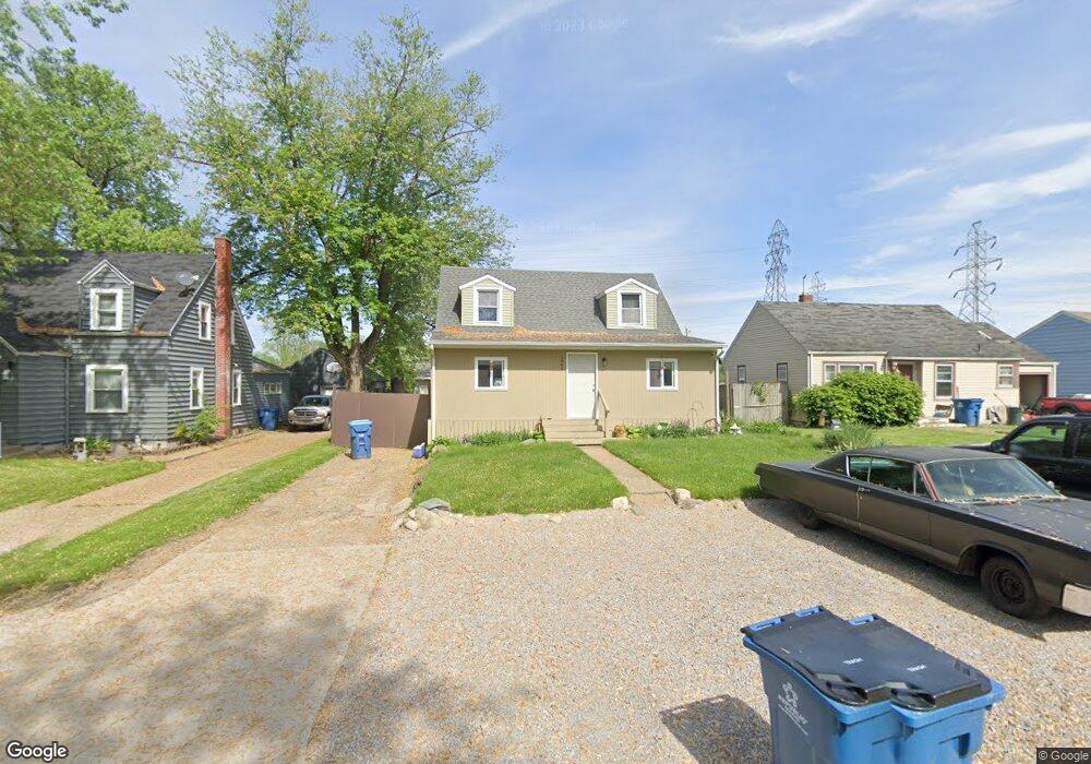
1945 Dellwood Dr Fort Wayne, IN 46803
Adams Township NeighborhoodEstimated Value: $171,000 - $198,000
3
Beds
2
Baths
1,298
Sq Ft
$139/Sq Ft
Est. Value
About This Home
This home is located at 1945 Dellwood Dr, Fort Wayne, IN 46803 and is currently estimated at $180,985, approximately $139 per square foot. 1945 Dellwood Dr is a home located in Allen County with nearby schools including New Haven Primary School, New Haven Intermediate School, and New Haven High School.
Ownership History
Date
Name
Owned For
Owner Type
Purchase Details
Closed on
Nov 14, 2018
Sold by
Beckman Anthony and Beckman Stacy L
Bought by
Beckman Anthony W and Beckman Stacy L
Current Estimated Value
Purchase Details
Closed on
Mar 10, 2006
Sold by
Hud
Bought by
Beckman Anthony and Kissinger Stacy
Home Financials for this Owner
Home Financials are based on the most recent Mortgage that was taken out on this home.
Original Mortgage
$50,000
Interest Rate
11.75%
Mortgage Type
Fannie Mae Freddie Mac
Purchase Details
Closed on
Jun 15, 2005
Sold by
Nationwide Home Mortgage Co
Bought by
Hud
Purchase Details
Closed on
May 25, 2005
Sold by
Richardson James G and Richardson Linda K
Bought by
Nationwide Home Mortgage Co
Create a Home Valuation Report for This Property
The Home Valuation Report is an in-depth analysis detailing your home's value as well as a comparison with similar homes in the area
Home Values in the Area
Average Home Value in this Area
Purchase History
| Date | Buyer | Sale Price | Title Company |
|---|---|---|---|
| Beckman Anthony W | -- | None Available | |
| Beckman Anthony | -- | Village Title Inc | |
| Hud | -- | Lawyers Title | |
| Nationwide Home Mortgage Co | $75,063 | Lawyers Title |
Source: Public Records
Mortgage History
| Date | Status | Borrower | Loan Amount |
|---|---|---|---|
| Previous Owner | Beckman Anthony | $50,000 |
Source: Public Records
Tax History Compared to Growth
Tax History
| Year | Tax Paid | Tax Assessment Tax Assessment Total Assessment is a certain percentage of the fair market value that is determined by local assessors to be the total taxable value of land and additions on the property. | Land | Improvement |
|---|---|---|---|---|
| 2024 | $1,479 | $160,800 | $9,500 | $151,300 |
| 2023 | $1,479 | $156,300 | $9,500 | $146,800 |
| 2022 | $1,245 | $128,000 | $9,500 | $118,500 |
| 2021 | $943 | $102,500 | $9,500 | $93,000 |
| 2020 | $829 | $96,700 | $9,500 | $87,200 |
| 2019 | $867 | $96,700 | $9,500 | $87,200 |
| 2018 | $668 | $83,000 | $9,500 | $73,500 |
| 2017 | $528 | $72,600 | $9,500 | $63,100 |
| 2016 | $559 | $51,800 | $9,500 | $42,300 |
| 2014 | $341 | $49,100 | $9,500 | $39,600 |
| 2013 | $316 | $45,000 | $9,500 | $35,500 |
Source: Public Records
Map
Nearby Homes
- 2130 Medford Dr
- 2611 Sheridan Rd
- 2510 Sheridan Rd Unit AC 41
- 2510 Sheridan Rd Unit AC 16
- 2510 Sheridan Rd
- 6510 Prize St
- 895 Chamberlin Ct
- 6713 Albatross Dr
- 6758 Wild Turkey Place
- 6776 Wild Turkey Place
- 2846 Turnpointe Blvd Unit F
- 2846 Turnpointe Blvd Unit A
- 6513 Parrott Rd
- 2409 Redwood Ave
- 640 Brandford Ct
- 556 Montclair Dr
- 4931 Nassau Dr
- 546 Kirkmore Dr
- 3533 Fritcha Ave
- 3618 Felician St
- 1955 Dellwood Dr
- 1943 Dellwood Dr
- 1941 Dellwood Dr
- 2003 Dellwood Dr
- 1939 Dellwood Dr
- 2011 Dellwood Dr
- 1937 Dellwood Dr
- 2017 Dellwood Dr
- 1948 Dellwood Dr
- 1944 Dellwood Dr
- 1954 Dellwood Dr
- 1940 Dellwood Dr
- 2021 Dellwood Dr
- 1964 Dellwood Dr
- 1932 Dellwood Dr
- 2014 Dellwood Dr
- 1924 Dellwood Dr
- 2025 Dellwood Dr
- 2018 Dellwood Dr
- 5920 New Haven Ave