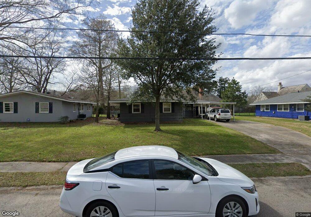
1946 Avondale Dr Baton Rouge, LA 70808
Mid City South NeighborhoodEstimated Value: $217,161 - $268,000
--
Bed
--
Bath
1,251
Sq Ft
$198/Sq Ft
Est. Value
About This Home
This home is located at 1946 Avondale Dr, Baton Rouge, LA 70808 and is currently estimated at $247,290, approximately $197 per square foot. 1946 Avondale Dr is a home located in East Baton Rouge Parish with nearby schools including Bernard Terrace Elementary School, Westdale Middle School, and Tara High School.
Ownership History
Date
Name
Owned For
Owner Type
Purchase Details
Closed on
Oct 30, 2019
Sold by
Dunlap Whitney Elizabeth
Bought by
Dunlap and Williams Heather Marie
Current Estimated Value
Home Financials for this Owner
Home Financials are based on the most recent Mortgage that was taken out on this home.
Original Mortgage
$153,000
Outstanding Balance
$134,868
Interest Rate
3.7%
Mortgage Type
New Conventional
Estimated Equity
$112,422
Purchase Details
Closed on
Sep 22, 2015
Sold by
Dunlaps Investments Llc
Bought by
Dunlap Whitney
Purchase Details
Closed on
Jan 15, 2013
Sold by
Johnson Gfirvus Eugenc
Bought by
Dunlap S Investments Llc
Create a Home Valuation Report for This Property
The Home Valuation Report is an in-depth analysis detailing your home's value as well as a comparison with similar homes in the area
Home Values in the Area
Average Home Value in this Area
Purchase History
| Date | Buyer | Sale Price | Title Company |
|---|---|---|---|
| Dunlap | $204,000 | Cypress Title Llc | |
| Dunlap Whitney | -- | None Available | |
| Dunlap S Investments Llc | $125,000 | -- |
Source: Public Records
Mortgage History
| Date | Status | Borrower | Loan Amount |
|---|---|---|---|
| Open | Dunlap | $153,000 |
Source: Public Records
Tax History Compared to Growth
Tax History
| Year | Tax Paid | Tax Assessment Tax Assessment Total Assessment is a certain percentage of the fair market value that is determined by local assessors to be the total taxable value of land and additions on the property. | Land | Improvement |
|---|---|---|---|---|
| 2024 | $2,270 | $19,380 | $2,000 | $17,380 |
| 2023 | $2,270 | $19,380 | $2,000 | $17,380 |
| 2022 | $2,314 | $19,380 | $2,000 | $17,380 |
| 2021 | $2,261 | $19,380 | $2,000 | $17,380 |
| 2020 | $2,246 | $19,380 | $2,000 | $17,380 |
| 2019 | $1,514 | $12,500 | $2,000 | $10,500 |
| 2018 | $1,495 | $12,500 | $2,000 | $10,500 |
| 2017 | $1,495 | $12,500 | $2,000 | $10,500 |
| 2016 | $1,458 | $12,500 | $2,000 | $10,500 |
| 2015 | $1,459 | $12,500 | $2,000 | $10,500 |
| 2014 | $1,454 | $12,500 | $2,000 | $10,500 |
| 2013 | -- | $5,250 | $2,000 | $3,250 |
Source: Public Records
Map
Nearby Homes
- 4936 Abelia Dr
- 1758 Marshall Dr
- 4624 Wells St
- 5065 Bardwell Dr
- 1547 Avondale Dr
- 1667 Ormandy Dr
- 1454 Ormandy Dr
- 4956 Bawell St
- 2100 College Dr Unit 63
- 2100 College Dr Unit 98
- 2100 College Dr Unit 186
- 2100 College Dr Unit 97
- 2100 College Dr Unit 174
- 4352 Woodside Dr
- 1958 Ingleside Dr
- 1755 College Dr Unit 121
- 1755 College Dr Unit 226
- 1755 College Dr Unit 215
- 1755 College Dr Unit 219
- 3151 College Dr
- 1970 Avondale Dr
- 1928 Avondale Dr
- 1929 Woodland Dr
- 2014 Avondale Dr
- 1939 Woodland Dr
- 1912 Avondale Dr
- 1929 Avondale Dr
- 1949 Woodland Dr
- 1957 Avondale Dr
- 1915 Avondale Dr
- 18269 Woodland Dr
- 0 Woodland Dr
- 2026 Avondale Dr
- 1919 Woodland Dr
- 1919 Woodland Dr
- 1866 Avondale Dr
- 2011 Avondale Dr
- 4645 Woodland Dr
- 1944 Woodland Dr
- 1971 Woodland Dr