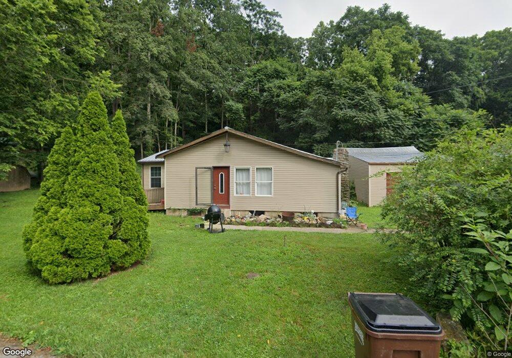
1946 Locust Dr Loveland, OH 45140
Estimated Value: $158,651 - $286,000
2
Beds
1
Bath
1,200
Sq Ft
$193/Sq Ft
Est. Value
About This Home
This home is located at 1946 Locust Dr, Loveland, OH 45140 and is currently estimated at $232,163, approximately $193 per square foot. 1946 Locust Dr is a home located in Warren County with nearby schools including Kings Junior High School, Kings High School, and St. Margaret of York School.
Ownership History
Date
Name
Owned For
Owner Type
Purchase Details
Closed on
Aug 11, 2015
Sold by
Royce Ronald and Royce Ron
Bought by
Grt Llc
Current Estimated Value
Purchase Details
Closed on
Jul 23, 2007
Sold by
Royce Rick and Royce Pamela
Bought by
Royce Ron
Purchase Details
Closed on
May 22, 2006
Sold by
Bussell Oscar and Wells Fargo Home Mortgage Inc
Bought by
Wells Fargo Bank Na
Purchase Details
Closed on
Jun 5, 1989
Sold by
Sharp Sharp and Sharp Margaret E
Bought by
Bussell Bussell and Bussell Oscar
Purchase Details
Closed on
May 2, 1986
Sold by
Sharp Sharp and Sharp Margaret
Bought by
Sharp Sharp and Sharp Margaret E
Create a Home Valuation Report for This Property
The Home Valuation Report is an in-depth analysis detailing your home's value as well as a comparison with similar homes in the area
Home Values in the Area
Average Home Value in this Area
Purchase History
| Date | Buyer | Sale Price | Title Company |
|---|---|---|---|
| Grt Llc | -- | Prodigy Title Agency | |
| Royce Ron | $11,260 | Prodigy Title | |
| Wells Fargo Bank Na | $43,300 | None Available | |
| Bussell Bussell | $25,000 | -- | |
| Sharp Sharp | -- | -- |
Source: Public Records
Tax History Compared to Growth
Tax History
| Year | Tax Paid | Tax Assessment Tax Assessment Total Assessment is a certain percentage of the fair market value that is determined by local assessors to be the total taxable value of land and additions on the property. | Land | Improvement |
|---|---|---|---|---|
| 2024 | $1,591 | $30,170 | $8,400 | $21,770 |
| 2023 | $1,316 | $22,746 | $4,130 | $18,616 |
| 2022 | $1,316 | $22,747 | $4,130 | $18,617 |
| 2021 | $1,104 | $22,747 | $4,130 | $18,617 |
| 2020 | $1,112 | $19,278 | $3,500 | $15,778 |
| 2019 | $1,127 | $19,278 | $3,500 | $15,778 |
| 2018 | $1,130 | $19,278 | $3,500 | $15,778 |
| 2017 | $1,164 | $17,735 | $3,273 | $14,462 |
| 2016 | $1,195 | $17,735 | $3,273 | $14,462 |
| 2015 | $1,089 | $17,735 | $3,273 | $14,462 |
| 2014 | $1,104 | $16,890 | $3,120 | $13,770 |
| 2013 | $1,106 | $18,970 | $3,500 | $15,470 |
Source: Public Records
Map
Nearby Homes
- 1312 Chestnut Dr
- 1942 Walnut St
- 9613 Vine Dr
- 9653 Shore Dr
- 2515 Hickory Rd
- 2513 Hickory Rd
- 2423 Hickory Rd
- 300 Oak Dr
- 0 Birch Dr
- 2612 Virgie Ct
- 9785 Rich Rd
- 9406 Nolin Orchard Ln
- 9023 Country View Ln
- 9900 Miami Dr
- 2680 Columbia Trail
- 2522 Fields Ertel Rd
- 9702 Amberwood Ct
- 12143 Cedar Dr
- 9299 White Pine Dr
- 2845 Columbia Trail
- 1970 Locust Dr
- 9491 Birch Dr
- 9457 Birch Dr
- 2016 Locust Dr
- 9503 Birch Dr
- 9447 Birch Dr
- 9447 Birch Dr
- 9447 Birch Dr
- 9447 Birch Dr
- 9492 Birch Dr
- 9414 Chestnut Dr
- 9437 Chestnut Dr
- 1315 Chestnut Dr
- 1313 Chestnut Dr
- 2030 Locust Dr
- 9475 Shore Dr
- 9413 Chestnut Dr
- 9411 Birch Dr
- 9487 Chestnut Dr
- 0 Chestnut Dr Unit 1473143