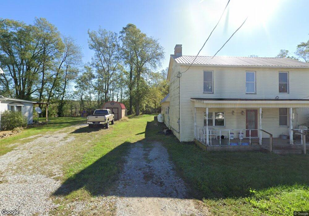
1946 State Route 73 Hillsboro, OH 45133
Estimated Value: $51,768 - $148,000
--
Bed
--
Bath
924
Sq Ft
$87/Sq Ft
Est. Value
About This Home
This home is located at 1946 State Route 73, Hillsboro, OH 45133 and is currently estimated at $80,442, approximately $87 per square foot. 1946 State Route 73 is a home located in Highland County with nearby schools including Bright Elementary School, Whiteoak Junior High School, and Whiteoak High School.
Ownership History
Date
Name
Owned For
Owner Type
Purchase Details
Closed on
May 1, 2025
Sold by
Beal Tiffney D
Bought by
C & P Michael Farms Llc
Current Estimated Value
Purchase Details
Closed on
Jun 22, 2023
Sold by
Beal Tiffney D
Bought by
Beal Tiffney D
Purchase Details
Closed on
Aug 3, 2016
Sold by
Skidmore Shirley
Bought by
Beal Tiffney D
Purchase Details
Closed on
Jan 1, 1990
Bought by
Skidmore Kenneth and Skidmore Shirley
Create a Home Valuation Report for This Property
The Home Valuation Report is an in-depth analysis detailing your home's value as well as a comparison with similar homes in the area
Home Values in the Area
Average Home Value in this Area
Purchase History
| Date | Buyer | Sale Price | Title Company |
|---|---|---|---|
| C & P Michael Farms Llc | $24,000 | None Listed On Document | |
| C & P Michael Farms Llc | $24,000 | None Listed On Document | |
| Beal Tiffney D | -- | None Listed On Document | |
| C & P Michael Farms Llc | $45,000 | None Listed On Document | |
| C & P Michael Farms Llc | $45,000 | None Listed On Document | |
| Beal Tiffney D | -- | None Available | |
| Skidmore Kenneth | -- | -- |
Source: Public Records
Tax History Compared to Growth
Tax History
| Year | Tax Paid | Tax Assessment Tax Assessment Total Assessment is a certain percentage of the fair market value that is determined by local assessors to be the total taxable value of land and additions on the property. | Land | Improvement |
|---|---|---|---|---|
| 2024 | $118 | $11,800 | $11,800 | $0 |
| 2023 | $115 | $22,930 | $22,930 | $0 |
| 2022 | $205 | $22,930 | $22,930 | $0 |
| 2021 | $196 | $5,850 | $5,850 | $0 |
| 2020 | $289 | $8,300 | $8,300 | $0 |
| 2019 | $287 | $8,300 | $8,300 | $0 |
| 2018 | $288 | $8,300 | $8,300 | $0 |
| 2017 | $404 | $11,620 | $11,620 | $0 |
| 2016 | $404 | $11,620 | $11,620 | $0 |
| 2015 | $405 | $11,620 | $11,620 | $0 |
| 2014 | $206 | $5,680 | $5,680 | $0 |
| 2013 | $206 | $5,680 | $5,680 | $0 |
Source: Public Records
Map
Nearby Homes
- 9963 Coss Rd
- 1717 Zion Ln
- 0 Rocklick Rd Unit 1850847
- 0 Rocklick Rd Unit 22305798
- 0 Rocklick Rd Unit 1827311
- 0 Rocklick Rd Unit 11401099
- 9888 E Deadfall Rd
- 9094 W Deadfall Rd
- 1865 Ohio 247
- 1445 Louisville Rd
- 1765 Greenbrier Rd
- 11883 Walnut Shade Rd
- 1318 Greenbrier Rd
- 2580 Concord Rd
- 289 Elmville Rd
- 10955 E Prospect Rd
- 12466 Sinking Spring Rd
- 4698 Bennington Rd
- 4724 Bennington Rd
- 4404 Louisville Rd
- 1960 State Route 73
- 1960 Route 73
- 1862 Cross St
- 1978 State Route 73
- 2004 State Route 73
- 2004 State Route 73
- 1932 State Route 73
- 1932 Ohio 73
- 1922 State Route 73
- 1872 State Route 73
- 2024 St Rt 73
- 1943 State Route 73
- 1929 State Route 73
- 1871 Ohio 73
- 1869 State Route 73
- 1869 St Rt 73
- 1989 St Rt 73
- 1917 State Route 73
- 1877 Cross St
- 1923 State Route 73