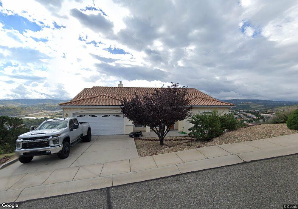
1947 Ventnor Cir Prescott, AZ 86301
Estimated Value: $626,569 - $738,000
3
Beds
2
Baths
2,697
Sq Ft
$255/Sq Ft
Est. Value
About This Home
This home is located at 1947 Ventnor Cir, Prescott, AZ 86301 and is currently estimated at $688,892, approximately $255 per square foot. 1947 Ventnor Cir is a home located in Yavapai County with nearby schools including Taylor Hicks School, Granite Mountain Middle School, and Prescott Mile High Middle School.
Ownership History
Date
Name
Owned For
Owner Type
Purchase Details
Closed on
Nov 26, 2007
Sold by
Devol Leroy T and Devol Nellie E
Bought by
Cohen Phillip and Gamburg Beth
Current Estimated Value
Home Financials for this Owner
Home Financials are based on the most recent Mortgage that was taken out on this home.
Original Mortgage
$470,000
Outstanding Balance
$298,412
Interest Rate
6.36%
Mortgage Type
New Conventional
Estimated Equity
$390,480
Purchase Details
Closed on
May 20, 2005
Sold by
Savage Enterprises Inc
Bought by
Devol Leroy T and Devol Nellie E
Home Financials for this Owner
Home Financials are based on the most recent Mortgage that was taken out on this home.
Original Mortgage
$208,000
Interest Rate
5.87%
Mortgage Type
Fannie Mae Freddie Mac
Create a Home Valuation Report for This Property
The Home Valuation Report is an in-depth analysis detailing your home's value as well as a comparison with similar homes in the area
Home Values in the Area
Average Home Value in this Area
Purchase History
| Date | Buyer | Sale Price | Title Company |
|---|---|---|---|
| Cohen Phillip | $410,000 | Chicago Title Insurance Co | |
| Devol Leroy T | -- | Capital Title Agency |
Source: Public Records
Mortgage History
| Date | Status | Borrower | Loan Amount |
|---|---|---|---|
| Open | Cohen Phillip | $470,000 | |
| Previous Owner | Devol Leroy T | $208,000 |
Source: Public Records
Tax History Compared to Growth
Tax History
| Year | Tax Paid | Tax Assessment Tax Assessment Total Assessment is a certain percentage of the fair market value that is determined by local assessors to be the total taxable value of land and additions on the property. | Land | Improvement |
|---|---|---|---|---|
| 2026 | $2,183 | $52,167 | -- | -- |
| 2024 | $2,138 | $54,905 | -- | -- |
| 2023 | $2,138 | $44,496 | $6,108 | $38,388 |
| 2022 | $2,096 | $37,678 | $5,845 | $31,833 |
| 2021 | $2,185 | $37,274 | $4,993 | $32,281 |
| 2020 | $2,188 | $0 | $0 | $0 |
| 2019 | $2,161 | $0 | $0 | $0 |
| 2018 | $2,084 | $0 | $0 | $0 |
| 2017 | $1,988 | $0 | $0 | $0 |
| 2016 | $2,001 | $0 | $0 | $0 |
| 2015 | -- | $0 | $0 | $0 |
| 2014 | -- | $0 | $0 | $0 |
Source: Public Records
Map
Nearby Homes
- 1935 Ventnor Cir
- 1961 Ventnor Cir
- 1883 Boardwalk Ave
- 462 Bloomingdale Dr
- 1456 Commonwealth St
- 450 Isabelle Ln
- 1353 Winfield Cir
- 422 Bloomingdale Dr
- 1226 Crown Ridge Dr
- 1899 Kensington Ct
- 1220 Pebble Springs
- 10825 W Rd
- 1748 Tatum Place
- 1920 Megan Way
- 1693 States St
- 1100 E Rosser St
- 500/501 E Rosser St
- 1790 Savage Ln S
- 423 Cabaret St
- 1283-1287 Raindagger Dr
- 1953 Ventnor Cir
- 1949 Ventnor Cir Unit 323
- 1949 Ventnor Cir
- 1945 Ventnor Cir
- 1945 Ventnor Cir Unit 321
- 1951 Ventnor Cir
- 1943 Ventnor Cir
- 1952 Ventnor
- 1948 Ventnor Cir
- 1950 Ventnor Cir
- 1944 Ventnor Cir
- 1944 Ventnor Cir Unit 4
- 1942 Boardwalk Ave
- 1946 Boardwalk Ave
- 1946 Boardwalk Ave Unit 3
- 1938 Boardwalk Ave Unit 3
- 1950 Boardwalk Ave
- 0 Ventnor Cir
- 1936 Ventnor Cir
- 1936 Ventnor Cir Unit 336