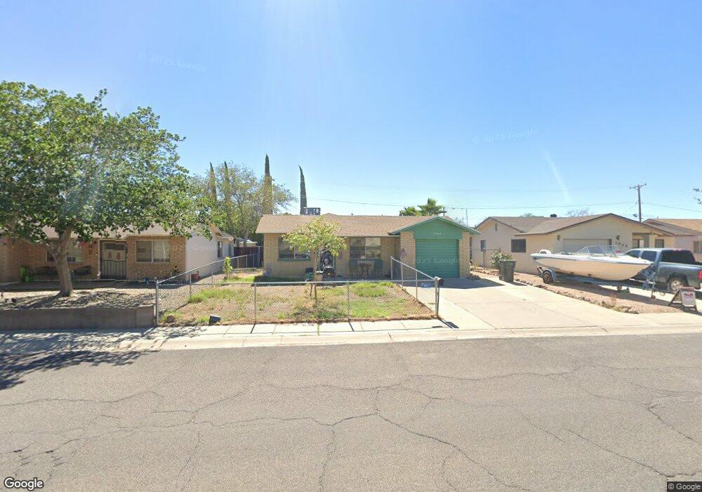
1948 Detroit Ave Kingman, AZ 86401
Estimated Value: $152,609 - $232,000
--
Bed
1
Bath
1,016
Sq Ft
$189/Sq Ft
Est. Value
About This Home
This home is located at 1948 Detroit Ave, Kingman, AZ 86401 and is currently estimated at $192,402, approximately $189 per square foot. 1948 Detroit Ave is a home located in Mohave County with nearby schools including Manzanita Elementary School, Kingman Middle School, and Kingman High School.
Ownership History
Date
Name
Owned For
Owner Type
Purchase Details
Closed on
Jul 6, 2001
Sold by
Bekaert Jerome J and Bekaert Rita J
Bought by
Coronado Isaias and Coronado Laura
Current Estimated Value
Home Financials for this Owner
Home Financials are based on the most recent Mortgage that was taken out on this home.
Original Mortgage
$72,000
Interest Rate
7.21%
Mortgage Type
New Conventional
Purchase Details
Closed on
Nov 18, 1999
Sold by
Hopkins Dale and Hopkins Carol
Bought by
Bekaert Jerome J and Bekaert Rita J
Home Financials for this Owner
Home Financials are based on the most recent Mortgage that was taken out on this home.
Original Mortgage
$53,650
Interest Rate
7.96%
Create a Home Valuation Report for This Property
The Home Valuation Report is an in-depth analysis detailing your home's value as well as a comparison with similar homes in the area
Home Values in the Area
Average Home Value in this Area
Purchase History
| Date | Buyer | Sale Price | Title Company |
|---|---|---|---|
| Coronado Isaias | $70,000 | State Title Agency Inc | |
| Bekaert Jerome J | $56,500 | First American Title |
Source: Public Records
Mortgage History
| Date | Status | Borrower | Loan Amount |
|---|---|---|---|
| Previous Owner | Coronado Isaias | $72,000 | |
| Previous Owner | Bekaert Jerome J | $53,650 |
Source: Public Records
Tax History Compared to Growth
Tax History
| Year | Tax Paid | Tax Assessment Tax Assessment Total Assessment is a certain percentage of the fair market value that is determined by local assessors to be the total taxable value of land and additions on the property. | Land | Improvement |
|---|---|---|---|---|
| 2026 | -- | -- | -- | -- |
| 2025 | $429 | $13,616 | $0 | $0 |
| 2024 | $429 | $16,247 | $0 | $0 |
| 2023 | $429 | $11,081 | $0 | $0 |
| 2022 | $393 | $8,642 | $0 | $0 |
| 2021 | $417 | $7,418 | $0 | $0 |
| 2019 | $376 | $7,238 | $0 | $0 |
| 2018 | $392 | $6,280 | $0 | $0 |
| 2017 | $355 | $5,220 | $0 | $0 |
| 2016 | $342 | $4,960 | $0 | $0 |
| 2015 | $357 | $4,187 | $0 | $0 |
Source: Public Records
Map
Nearby Homes
- 1939 Chicago Ave
- 1916 Pacific Ave
- 2041 Chicago Ave
- 1962 Hope Ave Unit 7
- 1951 Motor Ave
- 1737 Atlantic Ave
- 1953 Club Ave
- 1820 Motor Ave
- 1827 Davis Ave
- 1816 Motor Ave
- 2913 Western Ave
- 1834 Club Ave
- 2130 Club Ave
- 2727 Mullen Dr Unit 1
- 2504 Airfield Ct
- 1818 Golden Gate Ave
- 2209 Los Angeles St
- 1946 Gates Ave
- 2504 Golf Dr
- 2202 Los Angeles St
- 1952 Detroit Ave
- 1944 Detroit Ave
- 1956 Detroit Ave
- 1940 Detroit Ave
- 1945 Chicago Ave
- 1951 Chicago Ave
- 1955 Chicago Ave
- 1962 Detroit Ave
- 1934 Detroit Ave
- 1935 Chicago Ave
- 1961 Chicago Ave
- 1968 Detroit Ave
- 1930 Detroit Ave
- 1929 Chicago Ave
- 1967 Chicago Ave
- 1952 Chicago Ave
- 1942 Chicago Ave
- 1954 Chicago Ave
- 1972 Detroit Ave
- 1924 Detroit Ave