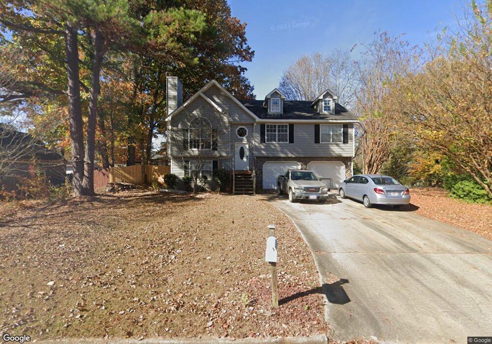
1948 Stonebrook Way Lawrenceville, GA 30043
Estimated Value: $368,000 - $386,000
3
Beds
3
Baths
1,438
Sq Ft
$261/Sq Ft
Est. Value
About This Home
This home is located at 1948 Stonebrook Way, Lawrenceville, GA 30043 and is currently estimated at $375,777, approximately $261 per square foot. 1948 Stonebrook Way is a home located in Gwinnett County with nearby schools including Taylor Elementary School, Creekland Middle School, and Collins Hill High School.
Ownership History
Date
Name
Owned For
Owner Type
Purchase Details
Closed on
Dec 9, 2005
Sold by
Oliviera Robert F and Oliviera Maureen F
Bought by
Dimitroff Michelle
Current Estimated Value
Home Financials for this Owner
Home Financials are based on the most recent Mortgage that was taken out on this home.
Original Mortgage
$125,000
Outstanding Balance
$79,456
Interest Rate
8.69%
Mortgage Type
New Conventional
Estimated Equity
$296,321
Purchase Details
Closed on
Nov 13, 1998
Sold by
Oliviera Robert T
Bought by
Oliveria Robt T and Oliveria Maureen F
Home Financials for this Owner
Home Financials are based on the most recent Mortgage that was taken out on this home.
Original Mortgage
$60,000
Interest Rate
6.58%
Mortgage Type
New Conventional
Create a Home Valuation Report for This Property
The Home Valuation Report is an in-depth analysis detailing your home's value as well as a comparison with similar homes in the area
Home Values in the Area
Average Home Value in this Area
Purchase History
| Date | Buyer | Sale Price | Title Company |
|---|---|---|---|
| Dimitroff Michelle | $125,000 | -- | |
| Oliveria Robt T | -- | -- | |
| Oliveira Robert T | $124,000 | -- |
Source: Public Records
Mortgage History
| Date | Status | Borrower | Loan Amount |
|---|---|---|---|
| Open | Dimitroff Michelle | $125,000 | |
| Previous Owner | Oliveira Robert T | $60,000 |
Source: Public Records
Tax History Compared to Growth
Tax History
| Year | Tax Paid | Tax Assessment Tax Assessment Total Assessment is a certain percentage of the fair market value that is determined by local assessors to be the total taxable value of land and additions on the property. | Land | Improvement |
|---|---|---|---|---|
| 2024 | $5,145 | $134,280 | $32,800 | $101,480 |
| 2023 | $5,145 | $133,240 | $32,800 | $100,440 |
| 2022 | $4,871 | $127,560 | $32,800 | $94,760 |
| 2021 | $3,062 | $75,560 | $17,600 | $57,960 |
| 2020 | $3,078 | $75,560 | $17,600 | $57,960 |
| 2019 | $2,705 | $68,080 | $14,400 | $53,680 |
| 2018 | $2,703 | $68,080 | $14,400 | $53,680 |
| 2016 | $2,336 | $57,080 | $12,400 | $44,680 |
| 2015 | $2,359 | $57,080 | $12,400 | $44,680 |
| 2014 | -- | $57,080 | $12,400 | $44,680 |
Source: Public Records
Map
Nearby Homes
- 2050 Fortuna St
- 1955 Watson Falls Ct
- 12 Jacobs Farm Ln Unit 6
- 1930 Collins Hill Rd
- 83 Russell Rd
- 1870 Wildcat Trace Cir
- 1832 Shores Ridge Ct
- 260 Wildcat Lake Dr
- 81 Russell Rd
- 340 Rosedown Way
- 1931 Abinger Way
- 2135 Saint Thomas Way
- 2012 Little River Dr Unit 1
- 1833 Riverton Dr NW
- 1909 McLennon Ct
- 2167 Merrymount Dr
- 1894 Tyler Trace
- 1938 Stonebrook Way
- 1949 Stonebrook Way
- 1904 Tyler Trace
- 1885 Tyler Trace
- 2051 Amber Dawn Way
- 2041 Amber Dawn Way
- 1895 Tyler Trace
- 1928 Stonebrook Way
- 1875 Tyler Trace
- 2031 Amber Dawn Way
- 1905 Tyler Trace
- 1865 Tyler Trace
- 15 Stonebrook Place
- 0 Tyler Trace Unit 3122054
- 0 Tyler Trace
- 2282 NE Amber Creek Trail
- 1915 Tyler Trace
- 1854 Tyler Trace
- 2021 Amber Dawn Way