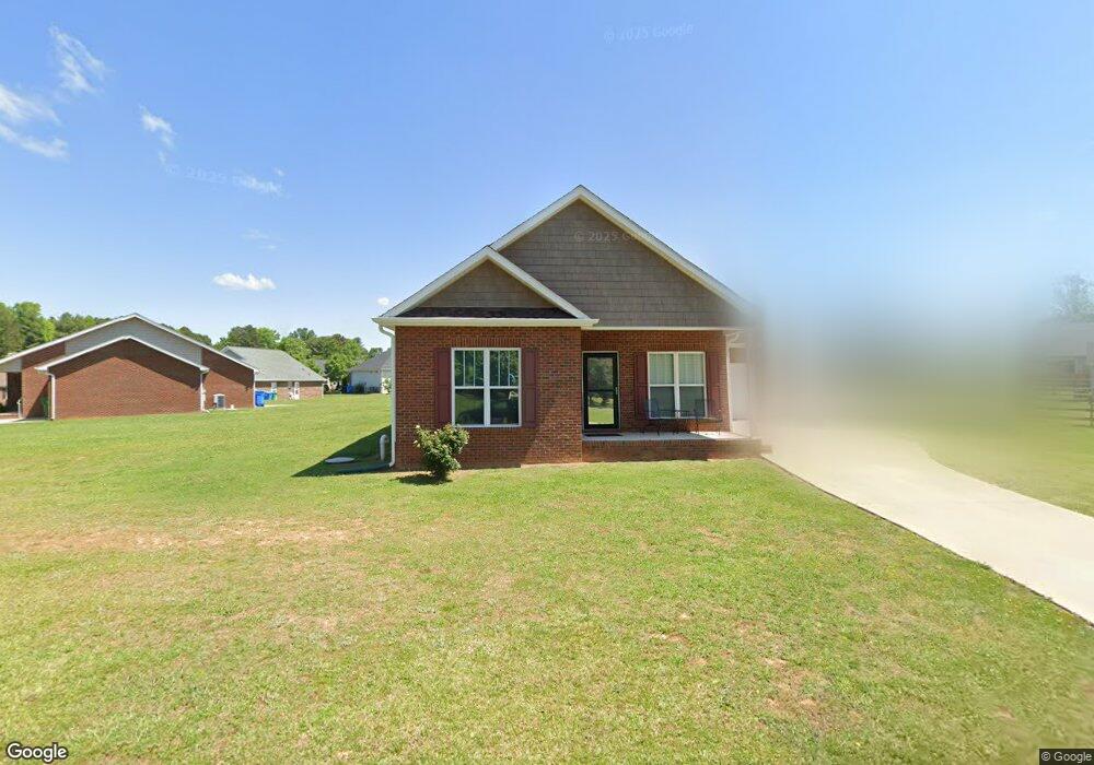
195 Abigail Ln Locust, NC 28097
Estimated Value: $329,000 - $387,000
2
Beds
2
Baths
1,210
Sq Ft
$286/Sq Ft
Est. Value
About This Home
This home is located at 195 Abigail Ln, Locust, NC 28097 and is currently estimated at $345,809, approximately $285 per square foot. 195 Abigail Ln is a home with nearby schools including Locust Elementary School, West Stanly Middle School, and West Stanly High School.
Ownership History
Date
Name
Owned For
Owner Type
Purchase Details
Closed on
Sep 1, 2021
Sold by
Turner Crystal Joy Armstrong and Turner Joseph Thomas
Bought by
Brucke Kathleen B
Current Estimated Value
Purchase Details
Closed on
Oct 8, 2018
Sold by
Afre 3 Llc
Bought by
Brucke Kathleen B and Armstrong Michael J
Purchase Details
Closed on
Dec 15, 2014
Sold by
Armstrong Thomas W and Armstrong Marla J
Bought by
Afre 3 Llc and Armstrong Family Limited Liability Partn
Purchase Details
Closed on
Mar 21, 2013
Sold by
Redah Acres Llc
Bought by
Armstrong Thomas W
Create a Home Valuation Report for This Property
The Home Valuation Report is an in-depth analysis detailing your home's value as well as a comparison with similar homes in the area
Home Values in the Area
Average Home Value in this Area
Purchase History
| Date | Buyer | Sale Price | Title Company |
|---|---|---|---|
| Brucke Kathleen B | -- | None Available | |
| Brucke Kathleen B | $25,000 | None Available | |
| Afre 3 Llc | -- | None Available | |
| Armstrong Thomas W | $200,000 | None Available |
Source: Public Records
Tax History Compared to Growth
Tax History
| Year | Tax Paid | Tax Assessment Tax Assessment Total Assessment is a certain percentage of the fair market value that is determined by local assessors to be the total taxable value of land and additions on the property. | Land | Improvement |
|---|---|---|---|---|
| 2025 | $2,321 | $252,328 | $58,500 | $193,828 |
| 2024 | $2,144 | $196,653 | $49,500 | $147,153 |
| 2023 | $2,264 | $196,653 | $49,500 | $147,153 |
| 2022 | $2,244 | $196,653 | $49,500 | $147,153 |
| 2021 | $2,224 | $196,653 | $49,500 | $147,153 |
| 2020 | $1,790 | $149,373 | $36,000 | $113,373 |
| 2019 | $407 | $36,000 | $36,000 | $0 |
| 2018 | $407 | $36,000 | $36,000 | $0 |
| 2017 | $407 | $36,000 | $36,000 | $0 |
| 2016 | $356 | $31,500 | $31,500 | $0 |
| 2015 | $355 | $31,500 | $31,500 | $0 |
| 2014 | $350 | $31,500 | $31,500 | $0 |
Source: Public Records
Map
Nearby Homes
- 402 Church St
- 540 Church St
- 211 Drive Inn Rd
- 708 Redah Ave
- 27 Berea Baptist Church Rd
- 174 Willow Creek Dr
- 417 Kiser Ln
- 110 Forest Dr
- 146 Kerri Dawn Ln
- 103 Berea Baptist Church Rd
- 105 Berea Baptist Church Rd
- 206 Montclair Dr
- 219 Kerri Dawn Ln
- 606 Elm St
- 716 Saddlebred Ln
- 347 Carolina Hemlock Dr
- 421 Carolina Hemlock Dr
- 201 Oak St
- 124 Hickory Ridge Dr
- 128 Hickory Ridge Dr
- 221 Abigail Ln
- 169 Abigail Ln
- 229 Abigail Ln Unit 9
- Vac Abigail Ln
- Vac Abigail Ln Unit 14
- 133 Abigail Ln
- 151 Abigail Ln
- 218 Abigail Ln
- 180 Abigail Ln
- 174 Abigail Ln
- 125 Abigail Ln Unit 15
- 166 Abigail Ln Unit 22
- 408 Church St
- 406 Church St
- Lot 13 Abigail Ln
- Lot 10 Abigail Ln
- Lot 22 Abigail Ln
- Lot 15 Abigail Ln
- Lot 20 Abigail Ln
- Lot 19 Abigail Ln