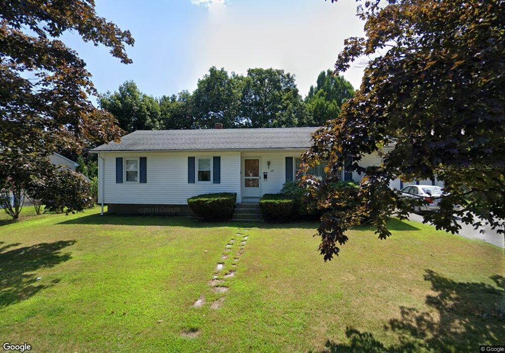
195 Brookside Rd Somerset, MA 02726
Pottersville NeighborhoodEstimated Value: $462,000 - $562,000
3
Beds
1
Bath
1,296
Sq Ft
$386/Sq Ft
Est. Value
About This Home
This home is located at 195 Brookside Rd, Somerset, MA 02726 and is currently estimated at $499,720, approximately $385 per square foot. 195 Brookside Rd is a home located in Bristol County with nearby schools including Chace Street School, Somerset Middle School, and St. Michael's School.
Create a Home Valuation Report for This Property
The Home Valuation Report is an in-depth analysis detailing your home's value as well as a comparison with similar homes in the area
Home Values in the Area
Average Home Value in this Area
Tax History
We collect this data history from publicly available records. To have your information removed, we recommend requesting removal directly through your county’s website.
| Year | Tax Paid | Tax Assessment Tax Assessment Total Assessment is a certain percentage of the fair market value that is determined by local assessors to be the total taxable value of land and additions on the property. | Land | Improvement |
|---|---|---|---|---|
| 2025 | $5,158 | $387,800 | $179,100 | $208,700 |
| 2024 | $4,858 | $379,800 | $179,100 | $200,700 |
| 2023 | $4,285 | $337,900 | $155,600 | $182,300 |
| 2022 | $3,955 | $297,600 | $134,200 | $163,400 |
| 2021 | $3,987 | $271,600 | $121,200 | $150,400 |
| 2020 | $4,021 | $264,200 | $121,300 | $142,900 |
| 2019 | $4,581 | $251,000 | $121,300 | $129,700 |
| 2018 | $3,510 | $232,000 | $116,800 | $115,200 |
| 2017 | $3,845 | $221,000 | $111,400 | $109,600 |
| 2016 | $3,870 | $221,000 | $111,400 | $109,600 |
| 2015 | $3,604 | $207,700 | $106,300 | $101,400 |
| 2014 | $4,871 | $201,700 | $103,300 | $98,400 |
Source: Public Records
Map
Nearby Homes
- 26 Robin Ln
- 8 Deer St
- 37 Henri St
- 442 Eastview Ave
- 442 Eastview Ave
- 194 Grove Ave
- 126 Grove Ave
- 46 Lilac Ave
- 92 Everett St
- 0 Bark St Unit 1342599
- 61 Stevens Rd
- 13 Wood St
- 224 Denham Ave
- 146 Colonial Dr
- 192 Calvin Ave
- 138 - 140 Berube Ave
- 2714 Riverside Ave
- 5 Nottingham Cir
- 185 Rosewood Rd
- 30 Gray St
- 7 Woodridge Rd
- 176 Regina Ave
- 145 Brookside Rd
- 8 Woodridge Rd
- 148 Brookside Rd
- 196 Regina Ave
- 154 Regina Ave
- 11 Woodridge Rd
- 128 Brookside Rd
- 115 Brookside Rd
- 22 Woodridge Rd
- 91 Midland Rd
- 134 Regina Ave
- 6 Brushwood Dr
- 216 Regina Ave
- 159 Regina Ave
- 27 Woodridge Rd
- 179 Regina Ave
- 24 Brushwood Dr
- 73 Midland Rd
Your Personal Tour Guide
Ask me questions while you tour the home.