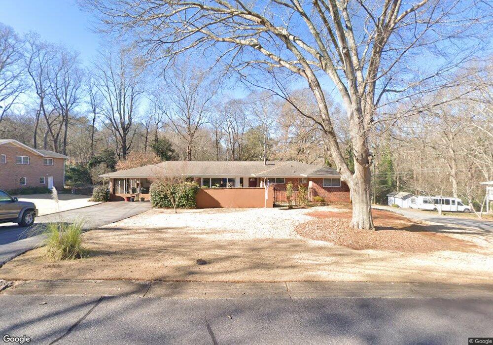
195 Devonshire Dr Athens, GA 30606
Saint George Place NeighborhoodEstimated Value: $310,309 - $485,000
Studio
--
Bath
2,085
Sq Ft
$184/Sq Ft
Est. Value
About This Home
This home is located at 195 Devonshire Dr, Athens, GA 30606 and is currently estimated at $384,577, approximately $184 per square foot. 195 Devonshire Dr is a home located in Clarke County with nearby schools including Timothy Elementary School, Clarke Middle School, and Clarke Central High School.
Ownership History
Date
Name
Owned For
Owner Type
Purchase Details
Closed on
Jan 3, 2003
Sold by
Davidson Nancy B
Bought by
Davidson Nancy B and Davidson Paul D
Current Estimated Value
Purchase Details
Closed on
Oct 4, 1994
Sold by
Duncan Scarlet Renee Roger A Medders
Bought by
Davidson Nancy B
Purchase Details
Closed on
Sep 24, 1991
Sold by
Secretary Of Veterans Affairs
Bought by
Duncan Scarlet Renee Roger A Medder
Purchase Details
Closed on
Oct 2, 1990
Sold by
Meritor Mortgage Corporation - East
Bought by
Secretary Of Veterans Affairs
Create a Home Valuation Report for This Property
The Home Valuation Report is an in-depth analysis detailing your home's value as well as a comparison with similar homes in the area
Home Values in the Area
Average Home Value in this Area
Purchase History
| Date | Buyer | Sale Price | Title Company |
|---|---|---|---|
| Davidson Nancy B | -- | -- | |
| Davidson Nancy B | $87,500 | -- | |
| Duncan Scarlet Renee Roger A Medder | -- | -- | |
| Secretary Of Veterans Affairs | $87,700 | -- | |
| Meritor Mortgage Corporation - East | $87,700 | -- |
Source: Public Records
Tax History
| Year | Tax Paid | Tax Assessment Tax Assessment Total Assessment is a certain percentage of the fair market value that is determined by local assessors to be the total taxable value of land and additions on the property. | Land | Improvement |
|---|---|---|---|---|
| 2025 | $2,095 | $111,687 | $20,000 | $91,687 |
| 2024 | $2,095 | $111,143 | $20,000 | $91,143 |
| 2023 | $947 | $99,900 | $20,000 | $79,900 |
| 2022 | $2,037 | $86,098 | $16,000 | $70,098 |
| 2021 | $1,930 | $70,101 | $12,000 | $58,101 |
| 2020 | $1,891 | $67,248 | $12,000 | $55,248 |
| 2019 | $1,878 | $65,318 | $12,000 | $53,318 |
| 2018 | $1,779 | $62,415 | $12,000 | $50,415 |
| 2017 | $1,766 | $62,008 | $12,000 | $50,008 |
| 2016 | $1,580 | $56,543 | $11,200 | $45,343 |
| 2015 | $1,492 | $53,881 | $11,200 | $42,681 |
| 2014 | $1,504 | $54,133 | $11,200 | $42,933 |
Source: Public Records
Map
Nearby Homes
- 255 Pine Valley Dr
- 1720 Timothy Rd
- 210 Pine Valley Dr
- 132 Branford Place
- 220 Tanglewood Dr
- 130 Wexford Place
- 255 Plum Nelly Rd
- 199 Tanglewood Dr
- 550 Fortson Rd
- 665 W Lake Dr
- 190 Bowles Dr Unit 1
- 190 Bowles Dr
- 205 Heritage Stroll
- 50 Pine Valley Dr
- 200 Skyline Pkwy
- 107 Beacham Dr
- 201 Township Ln
- 195 Sycamore Dr Unit C24
- 195 Sycamore Dr Unit E39
- 236 Towns Walk Dr
- 185 Devonshire Dr
- 240 Devonshire Dr
- 205 Devonshire Dr
- 180 Saint James Dr
- 400 Somerset Dr
- 175 Devonshire Dr
- 180 Devonshire Dr
- 170 Saint James Dr
- 200 Devonshire Dr
- 225 Devonshire Dr
- 375 Somerset Dr
- 165 Devonshire Dr
- 160 Devonshire Dr
- 195 Saint James Dr
- 220 Devonshire Dr
- 385 Somerset Dr
- 185 Saint James Dr
- 430 Somerset Dr
- 150 Saint James Dr
- 345 Somerset Dr
Your Personal Tour Guide
Ask me questions while you tour the home.