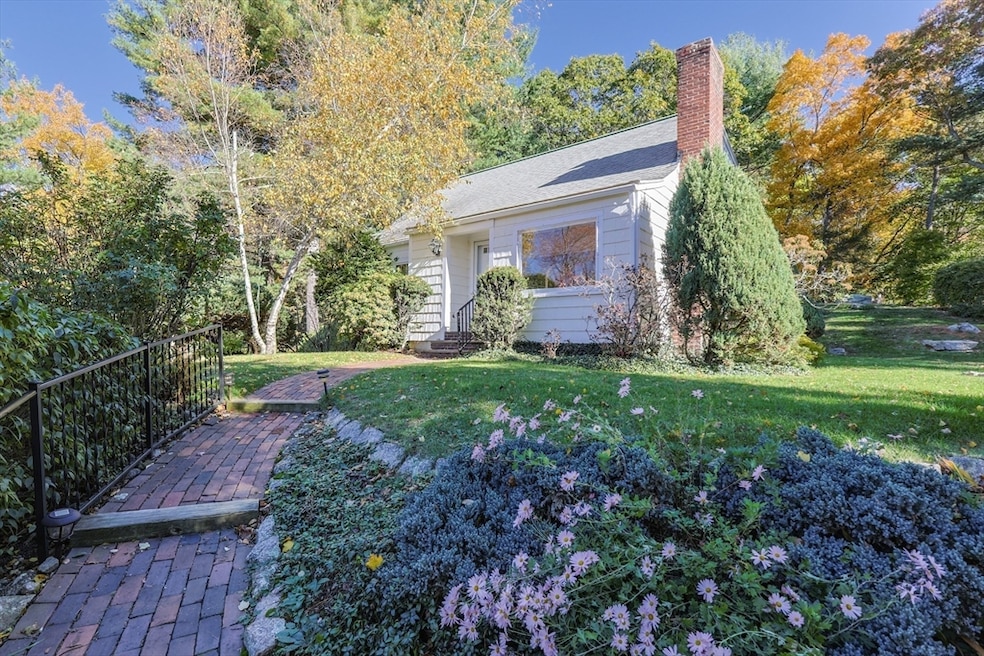
195 High St Holliston, MA 01746
Estimated payment $3,870/month
Highlights
- Golf Course Community
- Community Stables
- Deck
- Robert H. Adams Middle School Rated A
- Cape Cod Architecture
- Wooded Lot
About This Home
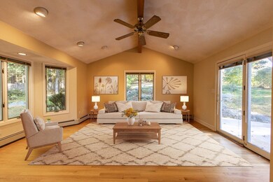
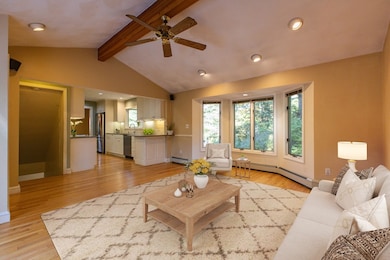
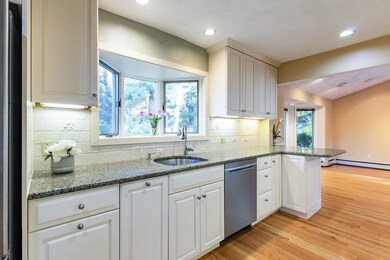
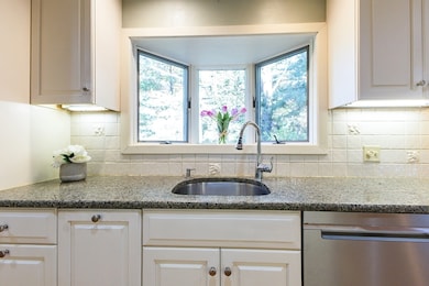
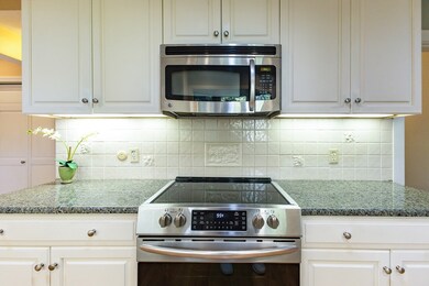
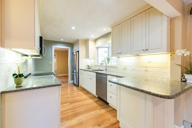
Sunday Open House Cancelled-Accepted Offer. This inviting Cape-style home filled w/warmth, character + thoughtful updates throughout. The light filled family room w/vaulted beamed ceiling, feels like the heart of the home - offers views of private backyard + walkout to deck surrounded by perennial rock gardens. Updated white kitchen w/granite counters + tile backsplash opens to both the family + dining rooms, creating a natural flow for everyday living and entertaining. Cozy living room w/fireplace, a first-floor bedroom or home office,and an updated full bath complete the main level. Upstairs you’ll find an updated full bath off of the primary bedroom, a second bedroom + a third room perfect for bedroom, guest room or office. The finished bonus room in the basement offers extra space to relax or work from home. With a two-car detached garage + updates including heating system, hot water heater, kitchen, exterior paint + more (see attached)-this is a home that’s been loved and cared
Listing Agent
Ritucci & Swift - Your Home Team
Realty Executives Boston West Listed on: 10/24/2025
Home Details
Home Type
- Single Family
Est. Annual Taxes
- $6,803
Year Built
- Built in 1950 | Remodeled
Lot Details
- 0.8 Acre Lot
- Wooded Lot
- Property is zoned 40
Parking
- 2 Car Detached Garage
- Off-Street Parking
Home Design
- Cape Cod Architecture
- Frame Construction
- Shingle Roof
- Concrete Perimeter Foundation
Interior Spaces
- Beamed Ceilings
- Vaulted Ceiling
- Recessed Lighting
- Bay Window
- Picture Window
- Sliding Doors
- Living Room with Fireplace
- Home Office
- Bonus Room
Kitchen
- Range
- Microwave
- Dishwasher
- Stainless Steel Appliances
- Solid Surface Countertops
Flooring
- Wood
- Wall to Wall Carpet
- Ceramic Tile
Bedrooms and Bathrooms
- 3 Bedrooms
- Primary bedroom located on second floor
- 2 Full Bathrooms
- Bathtub with Shower
- Separate Shower
- Linen Closet In Bathroom
Laundry
- Dryer
- Washer
Partially Finished Basement
- Basement Fills Entire Space Under The House
- Laundry in Basement
Outdoor Features
- Deck
Utilities
- No Cooling
- Heating System Uses Oil
- Baseboard Heating
- Hot Water Heating System
- Private Sewer
Listing and Financial Details
- Assessor Parcel Number 526370
Community Details
Overview
- No Home Owners Association
- Near Conservation Area
Amenities
- Shops
Recreation
- Golf Course Community
- Tennis Courts
- Park
- Community Stables
- Jogging Path
- Bike Trail
Map
Home Values in the Area
Average Home Value in this Area
Tax History
| Year | Tax Paid | Tax Assessment Tax Assessment Total Assessment is a certain percentage of the fair market value that is determined by local assessors to be the total taxable value of land and additions on the property. | Land | Improvement |
|---|---|---|---|---|
| 2025 | $6,803 | $464,400 | $284,700 | $179,700 |
| 2024 | $6,604 | $438,500 | $284,700 | $153,800 |
| 2023 | $5,857 | $380,300 | $237,300 | $143,000 |
| 2022 | $6,304 | $362,700 | $237,300 | $125,400 |
| 2021 | $6,492 | $363,700 | $228,600 | $135,100 |
| 2020 | $6,530 | $346,400 | $228,800 | $117,600 |
| 2019 | $6,054 | $321,500 | $199,100 | $122,400 |
| 2018 | $6,002 | $321,500 | $199,100 | $122,400 |
| 2017 | $5,875 | $317,200 | $191,200 | $126,000 |
| 2016 | $5,960 | $317,200 | $191,200 | $126,000 |
| 2015 | $5,264 | $271,600 | $149,100 | $122,500 |
Property History
| Date | Event | Price | List to Sale | Price per Sq Ft |
|---|---|---|---|---|
| 11/15/2025 11/15/25 | Pending | -- | -- | -- |
| 11/13/2025 11/13/25 | Price Changed | $629,900 | -2.9% | $374 / Sq Ft |
| 10/24/2025 10/24/25 | For Sale | $649,000 | -- | $385 / Sq Ft |
Purchase History
| Date | Type | Sale Price | Title Company |
|---|---|---|---|
| Not Resolvable | $2,085,000 | -- | |
| Deed | $45,000 | -- |
Mortgage History
| Date | Status | Loan Amount | Loan Type |
|---|---|---|---|
| Previous Owner | $220,000 | No Value Available | |
| Previous Owner | $100,000 | No Value Available |
Source: MLS Property Information Network (MLS PIN)
MLS Number: 73447655
APN: HOLL-000011-000004-000100
Disclaimer: Certain information contained herein is derived from information provided by parties other than Homes.com. All information provided is deemed reliable, but is not guaranteed to be accurate and should be independently verified.
![]() The property listing data and information, or the Images, set forth herein were provided to MLS Property Information Network, Inc. from third party sources, including sellers, lessors and public records, and were compiled by MLS Property Information Network, Inc. The property listing data and information, and the Images, are for the personal, non-commercial use of consumers having a good faith interest in purchasing or leasing listed properties of the type displayed to them and may not be used for any purpose other than to identify prospective properties which such consumers may have a good faith interest in purchasing or leasing. MLS Property Information Network, Inc. and its subscribers disclaim any and all representations and warranties as to the accuracy of the property listing data and information, or as to the accuracy of any of the Images, set forth herein.
The property listing data and information, or the Images, set forth herein were provided to MLS Property Information Network, Inc. from third party sources, including sellers, lessors and public records, and were compiled by MLS Property Information Network, Inc. The property listing data and information, and the Images, are for the personal, non-commercial use of consumers having a good faith interest in purchasing or leasing listed properties of the type displayed to them and may not be used for any purpose other than to identify prospective properties which such consumers may have a good faith interest in purchasing or leasing. MLS Property Information Network, Inc. and its subscribers disclaim any and all representations and warranties as to the accuracy of the property listing data and information, or as to the accuracy of any of the Images, set forth herein.
- 131 Jennings Rd
- 56 Roy Ave
- 32 Colonial Way
- 54 Westfield Dr
- 133 Brooksmont Dr Unit 43
- 95 Brooksmont Dr Unit 26
- 11 Francine Dr
- 150 Westfield Dr
- 160 Winter St
- 151 Mohawk Path
- 59 Turner Rd
- 147 Turner Rd Unit 80
- 152 Turner Rd Unit 43
- 152 Turner Rd Unit 14
- 6 Brook St
- 43 Bittersweet Cir Unit 43
- 306 Trailside Way
- 74 Meeting House Path
- 72 Meeting House Path
- 67 Spyglass Hill Dr