Estimated Value: $783,947 - $861,000
3
Beds
3
Baths
2,248
Sq Ft
$370/Sq Ft
Est. Value
About This Home
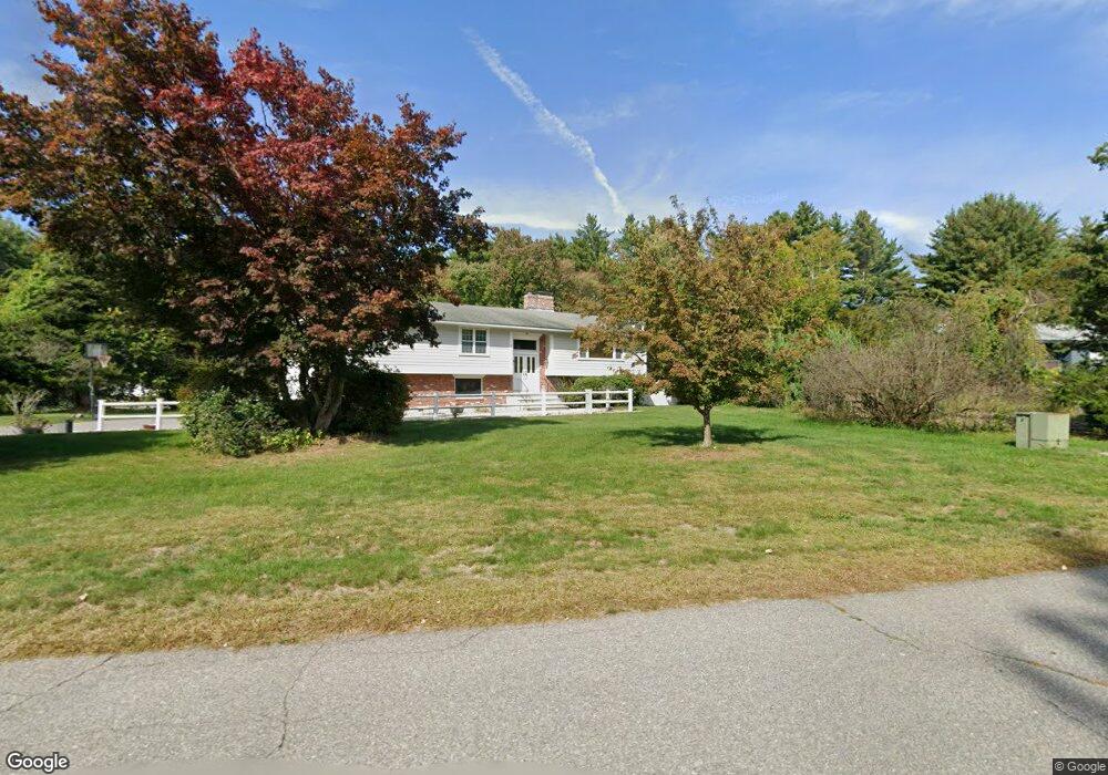
This home is located at 195 Kirkland Dr, Stow, MA 01775 and is currently estimated at $831,987, approximately $370 per square foot. 195 Kirkland Dr is a home located in Middlesex County with nearby schools including Center School, Hale Middle School, and Nashoba Regional High School.
Ownership History
Date
Name
Owned For
Owner Type
Purchase Details
Closed on
Aug 12, 2015
Sold by
Schwenk Leslie
Bought by
Leslie Schwenk Ret
Current Estimated Value
Purchase Details
Closed on
Dec 12, 1997
Sold by
Vegeais James and Rzechula Dana
Bought by
Schwenk Leslie
Home Financials for this Owner
Home Financials are based on the most recent Mortgage that was taken out on this home.
Original Mortgage
$190,000
Interest Rate
7.14%
Mortgage Type
Purchase Money Mortgage
Purchase Details
Closed on
Jan 13, 1995
Sold by
Laingen Paul C and Laingen Shirley D
Bought by
Vegais James and Rzechula Dana
Home Financials for this Owner
Home Financials are based on the most recent Mortgage that was taken out on this home.
Original Mortgage
$198,000
Interest Rate
9.23%
Mortgage Type
Purchase Money Mortgage
Create a Home Valuation Report for This Property
The Home Valuation Report is an in-depth analysis detailing your home's value as well as a comparison with similar homes in the area
Home Values in the Area
Average Home Value in this Area
Purchase History
| Date | Buyer | Sale Price | Title Company |
|---|---|---|---|
| Leslie Schwenk Ret | -- | -- | |
| Schwenk Leslie | $248,000 | -- | |
| Vegais James | $220,000 | -- |
Source: Public Records
Mortgage History
| Date | Status | Borrower | Loan Amount |
|---|---|---|---|
| Previous Owner | Vegais James | $190,000 | |
| Previous Owner | Vegais James | $196,500 | |
| Previous Owner | Vegais James | $198,000 | |
| Previous Owner | Vegais James | $115,000 |
Source: Public Records
Tax History Compared to Growth
Tax History
| Year | Tax Paid | Tax Assessment Tax Assessment Total Assessment is a certain percentage of the fair market value that is determined by local assessors to be the total taxable value of land and additions on the property. | Land | Improvement |
|---|---|---|---|---|
| 2025 | $11,940 | $685,400 | $337,000 | $348,400 |
| 2024 | $12,517 | $737,600 | $370,500 | $367,100 |
| 2023 | $12,352 | $681,300 | $331,200 | $350,100 |
| 2022 | $11,456 | $585,700 | $255,000 | $330,700 |
| 2021 | $11,109 | $556,000 | $255,000 | $301,000 |
| 2020 | $10,095 | $489,800 | $235,400 | $254,400 |
| 2019 | $10,148 | $504,100 | $235,400 | $268,700 |
| 2018 | $10,272 | $489,600 | $235,400 | $254,200 |
| 2017 | $9,823 | $477,100 | $209,700 | $267,400 |
| 2016 | $9,019 | $451,400 | $209,700 | $241,700 |
| 2015 | $8,434 | $422,100 | $190,700 | $231,400 |
Source: Public Records
Map
Nearby Homes
- 13 Pine Hill Way
- 14 Pine Hill Way
- 16 A Pine Hill Way Unit 16AA
- 18 B Pine Hill Way Unit BB
- 184 Old Bolton Rd
- 76 Bolton Woods Way
- 207 Boxboro Rd
- 310 Codman Hill Rd Unit 35D
- 9 Cortland Dr Unit 9
- 1155 Burroughs Rd
- 51 Heather Ln Unit 51
- 28 Mcintosh Dr Unit 22
- 30-6 Taylor Rd
- 90 Corn Rd
- 68 Hudson Rd
- 94 Hudson Rd
- 19 Partridge Hill Rd
- 96 Cedarwood Rd
- 98 Meadow Rd
- 53 Swanson Ct Unit 36C
- 189 Kirkland Dr
- 205 Kirkland Dr
- 19 Garner Rd
- 183 Kirkland Dr
- 204 Kirkland Dr
- 31 Garner Rd
- 190 Kirkland Dr
- 177 Kirkland Dr
- 35 Garner Rd
- 184 Kirkland Dr
- 171 Kirkland Dr
- 39 Garner Rd
- 65 Conant Dr
- 1 No Name Rd
- 165 Kirkland Dr
- LOT 1 Bradley Ln
- LOT 6 Kettell Plain Rd
- Lot 44 Whispering Way
- LOT B Maple St
- LOT 2 Kettell Plain Rd