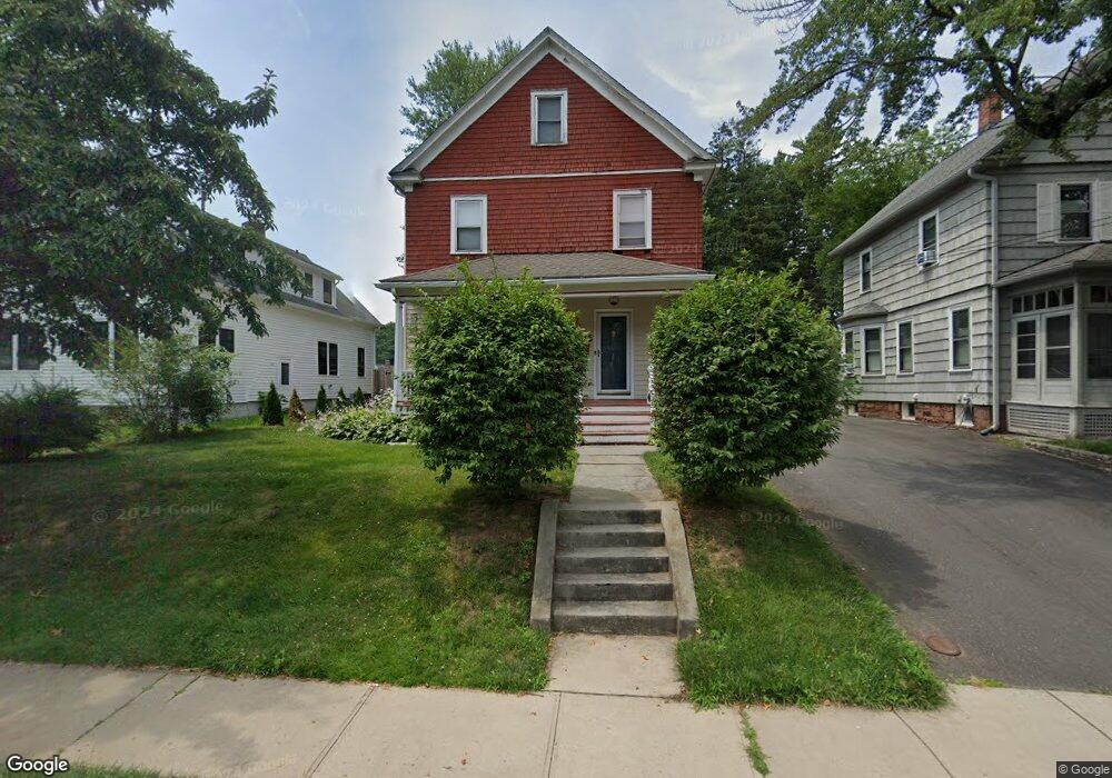
195 Raymond Rd West Hartford, CT 06107
Estimated Value: $458,556 - $565,000
3
Beds
2
Baths
1,536
Sq Ft
$332/Sq Ft
Est. Value
About This Home
This home is located at 195 Raymond Rd, West Hartford, CT 06107 and is currently estimated at $510,639, approximately $332 per square foot. 195 Raymond Rd is a home located in Hartford County with nearby schools including Webster Hill School, Sedgwick Middle School, and Conard High School.
Ownership History
Date
Name
Owned For
Owner Type
Purchase Details
Closed on
Aug 21, 2003
Sold by
Pepe Jon T and Pepe Jacqueline G
Bought by
Tarasuk Paul D and Tarasuk Janet R
Current Estimated Value
Home Financials for this Owner
Home Financials are based on the most recent Mortgage that was taken out on this home.
Original Mortgage
$218,500
Outstanding Balance
$95,518
Interest Rate
5.52%
Estimated Equity
$415,122
Purchase Details
Closed on
Apr 18, 1995
Sold by
Toretto Stephen and Toretto Barbara
Bought by
Pepe John and Pepe Jacqueline
Create a Home Valuation Report for This Property
The Home Valuation Report is an in-depth analysis detailing your home's value as well as a comparison with similar homes in the area
Home Values in the Area
Average Home Value in this Area
Purchase History
| Date | Buyer | Sale Price | Title Company |
|---|---|---|---|
| Tarasuk Paul D | $230,000 | -- | |
| Pepe John | $100,500 | -- |
Source: Public Records
Mortgage History
| Date | Status | Borrower | Loan Amount |
|---|---|---|---|
| Open | Pepe John | $50,000 | |
| Open | Pepe John | $218,500 | |
| Previous Owner | Pepe John | $164,000 | |
| Previous Owner | Pepe John | $25,000 |
Source: Public Records
Tax History Compared to Growth
Tax History
| Year | Tax Paid | Tax Assessment Tax Assessment Total Assessment is a certain percentage of the fair market value that is determined by local assessors to be the total taxable value of land and additions on the property. | Land | Improvement |
|---|---|---|---|---|
| 2025 | $10,270 | $229,350 | $102,300 | $127,050 |
| 2024 | $9,713 | $229,350 | $102,300 | $127,050 |
| 2023 | $9,385 | $229,350 | $102,300 | $127,050 |
| 2022 | $9,330 | $229,350 | $102,300 | $127,050 |
| 2021 | $9,255 | $218,170 | $106,100 | $112,070 |
| 2020 | $8,424 | $201,530 | $99,400 | $102,130 |
| 2019 | $8,424 | $201,530 | $99,400 | $102,130 |
| 2018 | $8,263 | $201,530 | $99,400 | $102,130 |
| 2017 | $8,271 | $201,530 | $99,400 | $102,130 |
| 2016 | $7,282 | $184,310 | $91,840 | $92,470 |
| 2015 | $7,061 | $184,310 | $91,840 | $92,470 |
| 2014 | $6,888 | $184,310 | $91,840 | $92,470 |
Source: Public Records
Map
Nearby Homes
- 1640 Boulevard
- 85 Memorial Rd Unit 512
- 25 Ellsworth Rd
- 2 Arapahoe Rd Unit 313
- 2 Arapahoe Rd Unit 308
- 2 Arapahoe Rd Unit 611
- 2 Arapahoe Rd Unit 601
- 2 Arapahoe Rd Unit 510
- 2 Arapahoe Rd Unit 505
- 2 Arapahoe Rd Unit 604
- 2 Arapahoe Rd Unit 609
- 2 Arapahoe Rd Unit 607
- 2 Arapahoe Rd Unit 312
- 2 Arapahoe Rd Unit 603
- 2 Arapahoe Rd Unit 605
- 2 Arapahoe Rd Unit 613
- 2 Arapahoe Rd Unit 612
- 2 Arapahoe Rd Unit 310
- 2 Arapahoe Rd Unit 515
- 2 Arapahoe Rd Unit 606
- 191 Raymond Rd
- 6 Meadowbrook Rd
- 187 Raymond Rd
- 20 Meadowbrook Rd
- 5 Meadowbrook Rd
- 24 Meadowbrook Rd
- 1565 Boulevard
- 15 Meadowbrook Rd
- 1569 Boulevard
- 1563 Boulevard
- 19 Meadowbrook Rd
- 211 Raymond Rd
- 100 Meadowbrook Rd Unit 1st
- 100 Meadowbrook Rd Unit 2ND
- 100 Meadowbrook Rd Unit FIRST
- 100 Meadowbrook Rd
- 28 Meadowbrook Rd
- 192 Raymond Rd
- 1571 Boulevard
- 190 Raymond Rd