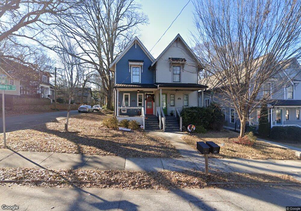
195 Stovall St SE Atlanta, GA 30316
Reynoldstown NeighborhoodEstimated Value: $734,404 - $888,000
4
Beds
3
Baths
2,080
Sq Ft
$381/Sq Ft
Est. Value
About This Home
This home is located at 195 Stovall St SE, Atlanta, GA 30316 and is currently estimated at $792,351, approximately $380 per square foot. 195 Stovall St SE is a home located in Fulton County with nearby schools including Burgess-Peterson Elementary School, King Middle School, and Maynard Holbrook Jackson High School.
Ownership History
Date
Name
Owned For
Owner Type
Purchase Details
Closed on
May 26, 2020
Sold by
Sheehan Jonathan
Bought by
Mccrate Anna M
Current Estimated Value
Home Financials for this Owner
Home Financials are based on the most recent Mortgage that was taken out on this home.
Original Mortgage
$641,000
Outstanding Balance
$568,197
Interest Rate
3.2%
Estimated Equity
$224,154
Purchase Details
Closed on
Jun 9, 2017
Sold by
Zirpoli Ron
Bought by
Sheehan Jonathan and Richards Jennifer
Create a Home Valuation Report for This Property
The Home Valuation Report is an in-depth analysis detailing your home's value as well as a comparison with similar homes in the area
Home Values in the Area
Average Home Value in this Area
Purchase History
| Date | Buyer | Sale Price | Title Company |
|---|---|---|---|
| Mccrate Anna M | $641,000 | -- | |
| Sheehan Jonathan | $500,000 | -- |
Source: Public Records
Mortgage History
| Date | Status | Borrower | Loan Amount |
|---|---|---|---|
| Open | Mccrate Anna M | $641,000 |
Source: Public Records
Tax History Compared to Growth
Tax History
| Year | Tax Paid | Tax Assessment Tax Assessment Total Assessment is a certain percentage of the fair market value that is determined by local assessors to be the total taxable value of land and additions on the property. | Land | Improvement |
|---|---|---|---|---|
| 2025 | $7,639 | $287,920 | $120,200 | $167,720 |
| 2023 | $11,975 | $289,240 | $120,200 | $169,040 |
| 2022 | $7,494 | $223,760 | $93,200 | $130,560 |
| 2021 | $8,254 | $243,680 | $90,480 | $153,200 |
| 2020 | $7,914 | $240,840 | $89,440 | $151,400 |
| 2019 | $8,669 | $264,560 | $87,840 | $176,720 |
| 2018 | $7,469 | $208,880 | $84,960 | $123,920 |
Source: Public Records
Map
Nearby Homes
- 919 Hughley Cir SE Unit 72
- 924 Hughley Cir SE Unit 85
- 920 Hughley Cir SE Unit 76
- 924 Hughley Cir SE Unit 84
- 921 Hughley Cir SE Unit 66
- 924 Hughley Cir SE Unit 82
- 127 Stein Steel St SE Unit 112
- 922 Hughley Cirlce Unit 81
- 952 Northern Ave SE
- 922 Hughley Cir SE Unit 81
- 948 Hughley Cir SE Unit 99
- 159 Walthall St SE Unit A
- 242 Wilbur Ave SE
- 174 Chester Ave SE Unit 116
- 81 Walthall St SE Unit B
- 81 Walthall St SE
- 920 Memorial Dr SE Unit 41
- 920 Memorial Dr SE Unit 35
- 920 Memorial Dr SE Unit 30
- 73 Kenyon St SE
- 195 Stovall St SE Unit B
- 195 Stovall St SE Unit A
- 189 Stovall St SE Unit B
- 189 Stovall St SE Unit A
- 189 Stovall St SE
- 205 Stovall St SE
- 977 Cummings St SE
- 209 Stovall St SE
- 192 Stovall St SE Unit ID1049156P
- 192 Stovall St SE
- 993 Mauldin St SE
- 991 Mauldin St SE Unit B
- 991 Mauldin St SE Unit A
- 991 Mauldin St SE
- 971 Cummings St SE
- 0 Cummings St SE Unit 7060272
- 0 Cummings St SE Unit 7605967
- 215 Stovall St SE
- 989 Mauldin St SE
- 194 Stovall St SE