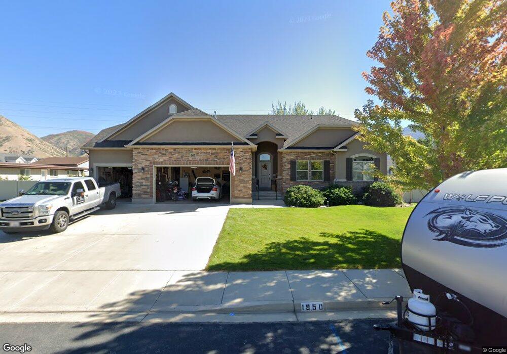
1950 N 1250 W Unit 19 Mapleton, UT 84664
Estimated Value: $810,000 - $1,007,000
3
Beds
3
Baths
1,776
Sq Ft
$510/Sq Ft
Est. Value
About This Home
This home is located at 1950 N 1250 W Unit 19, Mapleton, UT 84664 and is currently estimated at $906,173, approximately $510 per square foot. 1950 N 1250 W Unit 19 is a home located in Utah County with nearby schools including Mapleton School, Mapleton Junior High School, and Maple Mountain High School.
Ownership History
Date
Name
Owned For
Owner Type
Purchase Details
Closed on
Mar 4, 2025
Sold by
Malachowski Living Trust and Malachowski Matthew E
Bought by
Danny Black Trust and Black
Current Estimated Value
Home Financials for this Owner
Home Financials are based on the most recent Mortgage that was taken out on this home.
Original Mortgage
$752,000
Outstanding Balance
$748,276
Interest Rate
7.04%
Mortgage Type
New Conventional
Estimated Equity
$157,897
Purchase Details
Closed on
Dec 1, 2021
Sold by
Malachowski and Tracee
Bought by
Malachowski Living Trust
Purchase Details
Closed on
Sep 4, 2019
Sold by
Stowell Trent W and Stowell Mckenzie L
Bought by
Malachowski Tracec and Malachowski Matthew
Home Financials for this Owner
Home Financials are based on the most recent Mortgage that was taken out on this home.
Original Mortgage
$383,200
Interest Rate
3.7%
Purchase Details
Closed on
Apr 11, 2018
Sold by
Erickson Jill and Judith Ann Lassiter Family Tru
Bought by
Stowell Trent W and Stowell Mckenzie L
Home Financials for this Owner
Home Financials are based on the most recent Mortgage that was taken out on this home.
Original Mortgage
$408,500
Interest Rate
4.43%
Mortgage Type
New Conventional
Purchase Details
Closed on
Nov 2, 2015
Sold by
Lassiter Judith A and Hendrix Bellrae
Bought by
Lassiter Judith Ann
Purchase Details
Closed on
Apr 22, 2013
Sold by
D R Horton Inc
Bought by
Lassiter Judith A and Hendrix Bellrae
Home Financials for this Owner
Home Financials are based on the most recent Mortgage that was taken out on this home.
Original Mortgage
$243,992
Interest Rate
3.51%
Mortgage Type
New Conventional
Purchase Details
Closed on
Jan 5, 2009
Sold by
Miller Greg
Bought by
Sweet Iron Development Llc
Purchase Details
Closed on
Oct 22, 2008
Sold by
Gashler David E
Bought by
Miller Greg
Create a Home Valuation Report for This Property
The Home Valuation Report is an in-depth analysis detailing your home's value as well as a comparison with similar homes in the area
Home Values in the Area
Average Home Value in this Area
Purchase History
| Date | Buyer | Sale Price | Title Company |
|---|---|---|---|
| Danny Black Trust | -- | Inwest Title | |
| Malachowski Living Trust | -- | None Listed On Document | |
| Malachowski Tracec | -- | None Available | |
| Stowell Trent W | -- | First American Title | |
| Lassiter Judith Ann | -- | None Available | |
| Lassiter Judith A | -- | Provo Land Title Co | |
| Sweet Iron Development Llc | -- | Pro Title & Escrow Inc | |
| Miller Greg | -- | Bartlett Title Insurance Ag |
Source: Public Records
Mortgage History
| Date | Status | Borrower | Loan Amount |
|---|---|---|---|
| Open | Danny Black Trust | $752,000 | |
| Previous Owner | Malachowski Tracec | $383,200 | |
| Previous Owner | Stowell Trent W | $408,500 | |
| Previous Owner | Lassiter Judith A | $243,992 |
Source: Public Records
Tax History
| Year | Tax Paid | Tax Assessment Tax Assessment Total Assessment is a certain percentage of the fair market value that is determined by local assessors to be the total taxable value of land and additions on the property. | Land | Improvement |
|---|---|---|---|---|
| 2025 | $3,561 | $405,900 | -- | -- |
| 2024 | $3,561 | $348,865 | $0 | $0 |
| 2023 | $3,633 | $358,160 | $0 | $0 |
| 2022 | $4,125 | $402,105 | $0 | $0 |
| 2021 | $3,090 | $462,400 | $167,200 | $295,200 |
| 2020 | $3,062 | $443,200 | $148,000 | $295,200 |
| 2019 | $2,698 | $398,700 | $142,000 | $256,700 |
| 2018 | $2,526 | $355,300 | $119,600 | $235,700 |
| 2017 | $2,512 | $187,550 | $0 | $0 |
| 2016 | $2,472 | $183,425 | $0 | $0 |
| 2015 | $2,403 | $177,265 | $0 | $0 |
| 2014 | $2,273 | $164,670 | $0 | $0 |
Source: Public Records
Map
Nearby Homes
- 1121 W 1800 N
- 1403 S 625 E
- 949 S 1060 E
- 1264 E 1150 S
- 1518 S 600 E
- 899 E 800 S
- 598 W 1600 N
- 1525 S 400 E Unit 36
- 1697 N 500 W
- 1410 W 1200 N
- 405 W 1200 N Unit 4
- 487 W 1200 N Unit 1
- 677 E 800 South St
- 883 E 700 S
- 1518 E Pheasant Run Dr
- 579 E 800 St S
- 629 E 800 St S
- 1853 S 375 E
- 145 W Carnesecca Ct
- 1618 E 970 S
- 1950 N 1250 W
- 1235 W 2000 N
- 1920 N 1250 W Unit 18
- 1920 N 1250 W
- 1175 W 2000 N
- 1248 W 2000 N
- 1255 W 2000 N
- 1890 N 1250 W
- 1925 N 1250 W
- 1889 N 1100 W
- 1143 W 2000 N
- 1897 N 1250 W Unit 22
- 1313 W 2000 N
- 1860 N 1250 W Unit 16
- 1084 W 1900 N
- 942 E 1250 S
- 1857 N 1100 W
- 1115 W 2000 N
- 1245 S 950 E
- 1129 W 2000 N
Your Personal Tour Guide
Ask me questions while you tour the home.