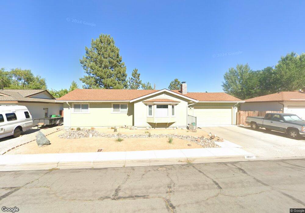
1951 Molly Dr Unit 9 Carson City, NV 89706
Northridge NeighborhoodEstimated Value: $457,796 - $486,000
3
Beds
3
Baths
1,872
Sq Ft
$250/Sq Ft
Est. Value
About This Home
This home is located at 1951 Molly Dr Unit 9, Carson City, NV 89706 and is currently estimated at $467,199, approximately $249 per square foot. 1951 Molly Dr Unit 9 is a home located in Carson City with nearby schools including Mark Twain Elementary School, Carson Middle School, and Carson High School.
Ownership History
Date
Name
Owned For
Owner Type
Purchase Details
Closed on
Apr 29, 2021
Sold by
Scanland Robert J and Scanland Jennifer L
Bought by
Markel James and Markel Elizabeth
Current Estimated Value
Home Financials for this Owner
Home Financials are based on the most recent Mortgage that was taken out on this home.
Original Mortgage
$335,135
Outstanding Balance
$303,241
Interest Rate
3%
Mortgage Type
Commercial
Estimated Equity
$163,958
Purchase Details
Closed on
Feb 23, 2011
Sold by
U S Bank National Association
Bought by
Scanland Robert J and Scanland Jennifer L
Purchase Details
Closed on
Jul 3, 2010
Sold by
Fox Rodney A and Fox Jennifer L
Bought by
U S Bank National Association
Purchase Details
Closed on
Jul 12, 2006
Sold by
Fox Rodney A and Fox Jennifer L
Bought by
Fox Rodney A and Fox Jennifer L
Home Financials for this Owner
Home Financials are based on the most recent Mortgage that was taken out on this home.
Original Mortgage
$262,500
Interest Rate
8.65%
Mortgage Type
New Conventional
Create a Home Valuation Report for This Property
The Home Valuation Report is an in-depth analysis detailing your home's value as well as a comparison with similar homes in the area
Home Values in the Area
Average Home Value in this Area
Purchase History
| Date | Buyer | Sale Price | Title Company |
|---|---|---|---|
| Markel James | $375,000 | Ticor Title C C | |
| Scanland Robert J | $71,000 | Ticor Title Of Nevada | |
| U S Bank National Association | $198,412 | First American National D | |
| Fox Rodney A | -- | None Available |
Source: Public Records
Mortgage History
| Date | Status | Borrower | Loan Amount |
|---|---|---|---|
| Open | Markel James | $335,135 | |
| Previous Owner | Fox Rodney A | $262,500 |
Source: Public Records
Tax History Compared to Growth
Tax History
| Year | Tax Paid | Tax Assessment Tax Assessment Total Assessment is a certain percentage of the fair market value that is determined by local assessors to be the total taxable value of land and additions on the property. | Land | Improvement |
|---|---|---|---|---|
| 2025 | $1,701 | $64,448 | $34,300 | $30,148 |
| 2024 | $1,651 | $65,727 | $34,300 | $31,427 |
| 2023 | $1,604 | $59,982 | $29,750 | $30,232 |
| 2022 | $1,557 | $51,644 | $23,800 | $27,844 |
| 2021 | $1,442 | $47,435 | $20,650 | $26,785 |
| 2019 | $1,341 | $43,241 | $16,800 | $26,441 |
| 2018 | $1,302 | $39,976 | $14,000 | $25,976 |
| 2017 | $1,264 | $38,904 | $12,600 | $26,304 |
| 2016 | $1,232 | $37,865 | $10,500 | $27,365 |
| 2015 | $1,229 | $37,384 | $9,625 | $27,759 |
| 2014 | $1,194 | $33,989 | $7,700 | $26,289 |
Source: Public Records
Map
Nearby Homes
- 1970 Hamilton Ave
- 1381 Spooner Dr
- 1654 Spooner Dr
- 2542 Ravenshorn Dr
- 2616 Carriage Crest Dr
- 2613 Pinion Pine Dr
- 2756 Table Rock Dr
- 2048 Poole Way
- 1902 Peters St
- 1955 F St
- 493 Hot Springs Rd Unit 1
- 493 Hot Springs Rd Unit 24
- 0 Research Way
- 1772 Hogan Peak St
- 2408 Bunch Way
- Cross Creek, Plan 6 at Cross Creek
- Cross Creek, Plan 3 at Cross Creek
- Cross Creek, Plan 1 at Cross Creek
- Cross Creek, Plan 4X at Cross Creek
- Cross Creek, Plan 2 at Cross Creek
- 1963 Molly Dr
- 1943 Molly Dr
- 1960 Carriage Crest Dr
- 1954 Carriage Crest Dr
- 1965 Molly Dr
- 1937 Molly Dr
- 1966 Carriage Crest Dr
- 1948 Carriage Crest Dr
- 1952 Molly Dr
- 1944 Molly Dr
- 1405 Karin Dr
- 1972 Carriage Crest Dr Unit 12B
- 1942 Carriage Crest Dr
- 1969 Molly Dr
- 1931 Molly Dr
- 1936 Molly Dr
- 1978 Carriage Crest Dr
- 1936 Carriage Crest Dr
- 1951 Beverly Dr
- 1943 Beverly Dr