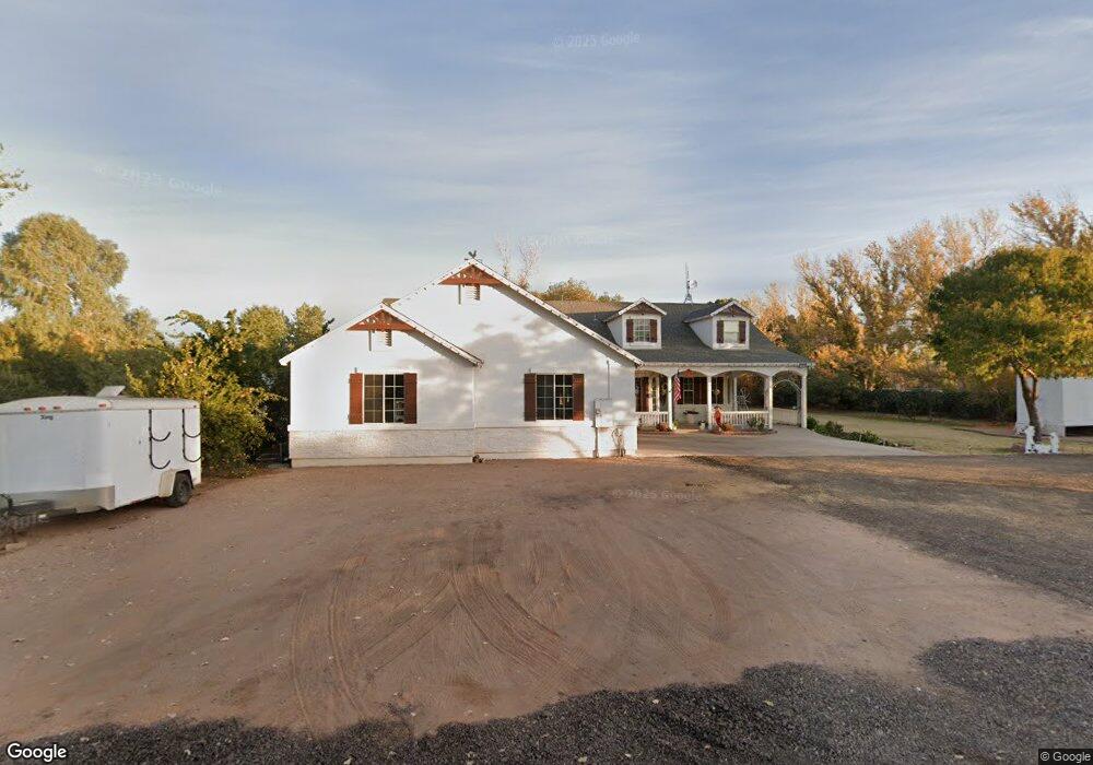
19520 E Aster Dr Queen Creek, AZ 85142
Estimated Value: $687,000 - $911,000
--
Bed
3
Baths
2,432
Sq Ft
$338/Sq Ft
Est. Value
About This Home
This home is located at 19520 E Aster Dr, Queen Creek, AZ 85142 and is currently estimated at $822,547, approximately $338 per square foot. 19520 E Aster Dr is a home located in Maricopa County with nearby schools including Desert Mountain Elementary School, Queen Creek Junior High School, and Benjamin Franklin Charter School - Power.
Ownership History
Date
Name
Owned For
Owner Type
Purchase Details
Closed on
May 15, 2005
Sold by
Nasser Mike J and Nasser Katherine A
Bought by
Ray Rusdon and Ray Emily
Current Estimated Value
Purchase Details
Closed on
Mar 17, 2005
Sold by
Adams Donna I and Winton Donna I
Bought by
Nasser Mike J and Nasser Katherine A
Purchase Details
Closed on
Aug 20, 1997
Sold by
Martin David W and Martin Dawn M
Bought by
Adams Don L
Purchase Details
Closed on
Aug 6, 1997
Sold by
Haydu Stefanie
Bought by
Martin David W and Martin Dawn M
Create a Home Valuation Report for This Property
The Home Valuation Report is an in-depth analysis detailing your home's value as well as a comparison with similar homes in the area
Home Values in the Area
Average Home Value in this Area
Purchase History
| Date | Buyer | Sale Price | Title Company |
|---|---|---|---|
| Ray Rusdon | $195,000 | Grand Canyon Title Agency In | |
| Nasser Mike J | $137,000 | Grand Canyon Title Agency In | |
| Adams Don L | -- | Lawyers Title Of Arizona Inc | |
| Martin David W | $44,000 | Lawyers Title Of Arizona Inc |
Source: Public Records
Tax History Compared to Growth
Tax History
| Year | Tax Paid | Tax Assessment Tax Assessment Total Assessment is a certain percentage of the fair market value that is determined by local assessors to be the total taxable value of land and additions on the property. | Land | Improvement |
|---|---|---|---|---|
| 2025 | $3,655 | $37,853 | -- | -- |
| 2024 | $3,677 | $36,050 | -- | -- |
| 2023 | $3,677 | $62,470 | $12,490 | $49,980 |
| 2022 | $3,441 | $48,360 | $9,670 | $38,690 |
| 2021 | $3,524 | $43,000 | $8,600 | $34,400 |
| 2020 | $3,489 | $39,580 | $7,910 | $31,670 |
| 2019 | $3,350 | $36,160 | $7,230 | $28,930 |
| 2018 | $3,299 | $30,970 | $6,190 | $24,780 |
| 2017 | $3,130 | $30,160 | $6,030 | $24,130 |
| 2016 | $3,104 | $28,580 | $5,710 | $22,870 |
| 2015 | $2,543 | $27,630 | $5,520 | $22,110 |
Source: Public Records
Map
Nearby Homes
- 19699 E Apricot Ln
- 19279 E Peartree Ln
- 19604 E Thornton Rd
- 20258 S 196th St
- 19943 E Augustus Ave
- 22219 S 191st Way
- 19837 E Thornton Rd
- 19319 E Thornton Rd
- 19880 E Apricot Ln
- 19943 E Strawberry Dr
- 19655 E Reins Rd
- 19813 E Carriage Way
- 21485 S 191st Place
- 19087 E Walnut Ct
- 21922 S 193rd Way
- 21975 S 193rd Way
- 19677 E Canary Way
- 20468 E Cloud Rd
- Catalina Plan at Legado - Summit Collection
- Palisade Plan at Legado - Summit Collection
- 19526 E Aster Dr
- 19514 E Aster Dr
- 20902 S 196th St
- 19517 E Aster Dr
- 19526 E Twin Acres Dr
- 19534 E Twin Acres Dr
- 19511 E Aster Dr
- 19523 E Aster Dr
- 19512 E Twin Acres Dr
- 19508 E Aster Dr
- 19505 E Aster Dr
- 21108 S 196th St
- 19504 E Twin Acres Dr
- 21102 S 196th St
- 19432 E Twin Acres Dr
- 21049 S 194th Place
- 20781 S 196th St
- 19691 E Julius Rd Unit 87
- 19691 E Julius Rd
- 20761 S 196th St