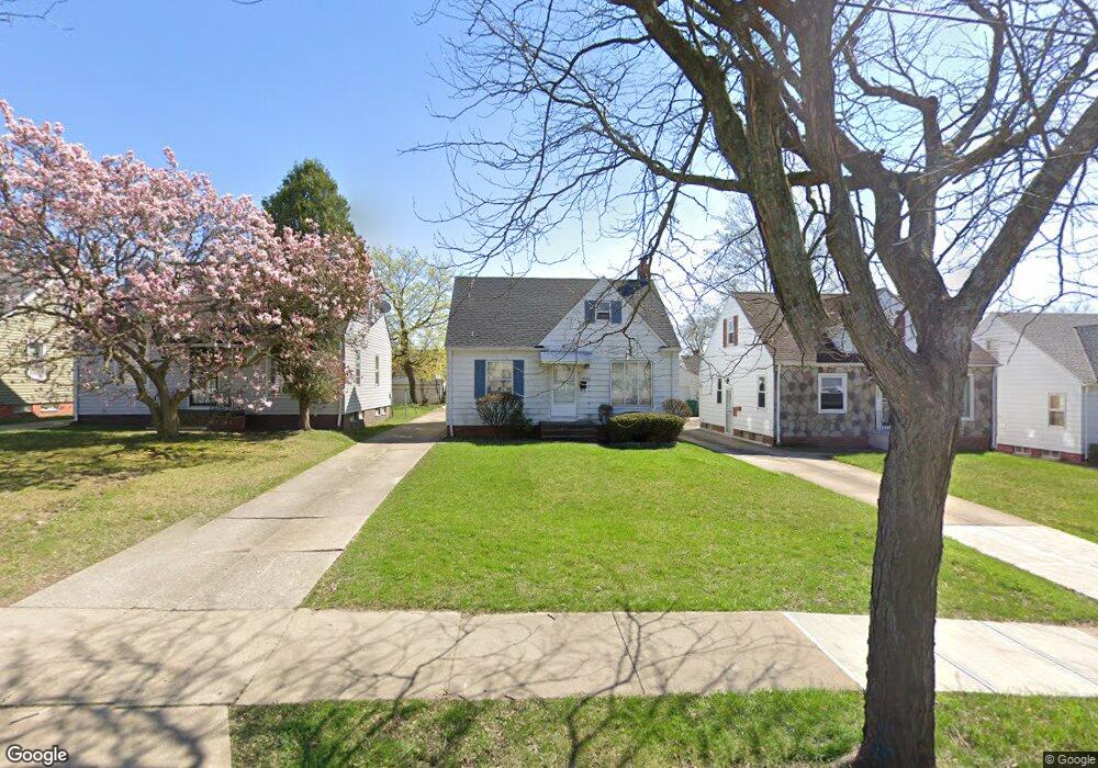
19524 Libby Rd Maple Heights, OH 44137
Estimated Value: $96,000 - $107,258
3
Beds
1
Bath
935
Sq Ft
$109/Sq Ft
Est. Value
About This Home
This home is located at 19524 Libby Rd, Maple Heights, OH 44137 and is currently estimated at $102,315, approximately $109 per square foot. 19524 Libby Rd is a home located in Cuyahoga County with nearby schools including Abraham Lincoln Elementary School, Rockside/ J.F. Kennedy School, and Italy High School.
Ownership History
Date
Name
Owned For
Owner Type
Purchase Details
Closed on
Mar 27, 2000
Sold by
Stanley Charles E and Stanley Patricia A
Bought by
Beasley Laquita R
Current Estimated Value
Home Financials for this Owner
Home Financials are based on the most recent Mortgage that was taken out on this home.
Original Mortgage
$61,100
Outstanding Balance
$21,173
Interest Rate
8.39%
Estimated Equity
$81,142
Purchase Details
Closed on
Feb 7, 1994
Sold by
Manghillis Mamie J
Bought by
Stanley Charles E
Purchase Details
Closed on
Feb 6, 1986
Sold by
Manghillis Aldo J
Bought by
Manghillis Mamie J
Purchase Details
Closed on
Mar 26, 1980
Sold by
Manghillis Mamie J
Bought by
Manghillis Aldo J
Purchase Details
Closed on
Jan 1, 1975
Bought by
Manghillis Mamie J
Create a Home Valuation Report for This Property
The Home Valuation Report is an in-depth analysis detailing your home's value as well as a comparison with similar homes in the area
Home Values in the Area
Average Home Value in this Area
Purchase History
| Date | Buyer | Sale Price | Title Company |
|---|---|---|---|
| Beasley Laquita R | $63,000 | City Title Company Agency In | |
| Stanley Charles E | $53,900 | -- | |
| Manghillis Mamie J | -- | -- | |
| Manghillis Aldo J | -- | -- | |
| Manghillis Mamie J | -- | -- |
Source: Public Records
Mortgage History
| Date | Status | Borrower | Loan Amount |
|---|---|---|---|
| Open | Beasley Laquita R | $61,100 |
Source: Public Records
Tax History Compared to Growth
Tax History
| Year | Tax Paid | Tax Assessment Tax Assessment Total Assessment is a certain percentage of the fair market value that is determined by local assessors to be the total taxable value of land and additions on the property. | Land | Improvement |
|---|---|---|---|---|
| 2024 | $3,236 | $35,910 | $5,250 | $30,660 |
| 2023 | $2,371 | $22,200 | $4,240 | $17,960 |
| 2022 | $2,362 | $22,190 | $4,240 | $17,960 |
| 2021 | $2,518 | $22,190 | $4,240 | $17,960 |
| 2020 | $2,154 | $16,840 | $3,220 | $13,620 |
| 2019 | $2,142 | $48,100 | $9,200 | $38,900 |
| 2018 | $2,131 | $16,840 | $3,220 | $13,620 |
| 2017 | $2,130 | $16,460 | $4,170 | $12,290 |
| 2016 | $2,061 | $16,460 | $4,170 | $12,290 |
| 2015 | $2,065 | $16,460 | $4,170 | $12,290 |
| 2014 | $2,065 | $18,100 | $4,590 | $13,510 |
Source: Public Records
Map
Nearby Homes
- 19520 Maple Heights Blvd
- 19289 Stafford Ave
- 19806 Mountville Dr
- 19221 Stafford Ave
- 19807 Gardenview Dr
- 19812 Stockton Ave
- 5265 Bellview St
- 5165 Camden Rd
- 18909 Maple Heights Blvd
- 20107 Libby Rd
- 19309 Nitra Ave
- 5409 Hollywood Ave
- 5357 Beechwood Ave
- 20510 Mountville Dr
- 5234 Erwin St
- 20701 Kenyon Dr
- 5571 Oakwood Ave
- 20120 Mccracken Rd
- 20814 Kenyon Dr
- 20625 Centuryway Rd
- 19528 Libby Rd
- 19520 Libby Rd
- 19602 Libby Rd
- 19516 Libby Rd
- 19277 Stockton Ave
- 19281 Stockton Ave
- 19273 Stockton Ave
- 19606 Libby Rd
- 19512 Libby Rd
- 19285 Stockton Ave
- 19269 Stockton Ave
- 19508 Libby Rd
- 19610 Libby Rd
- 19289 Stockton Ave
- 19265 Stockton Ave
- 19293 Stockton Ave
- 19261 Stockton Ave
- 19504 Libby Rd
- 19614 Libby Rd
- 19525 Libby Rd