Estimated Value: $571,000 - $674,000
4
Beds
3
Baths
2,381
Sq Ft
$259/Sq Ft
Est. Value
About This Home
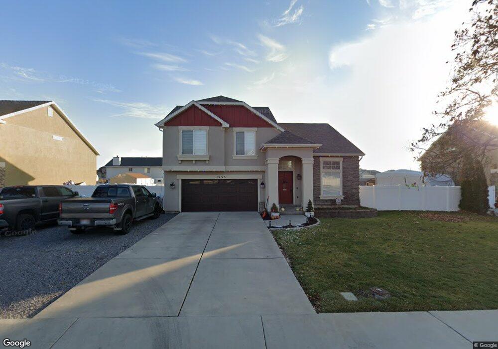
This home is located at 1953 W 1400 N, Lehi, UT 84043 and is currently estimated at $616,237, approximately $258 per square foot. 1953 W 1400 N is a home located in Utah County with nearby schools including North Point Elementary School, Willowcreek Middle School, and Lehi High School.
Ownership History
Date
Name
Owned For
Owner Type
Purchase Details
Closed on
Jun 17, 2024
Sold by
Jones James V and Jones Shelley R
Bought by
Flygare Skyler and Flygare Jessica
Current Estimated Value
Home Financials for this Owner
Home Financials are based on the most recent Mortgage that was taken out on this home.
Original Mortgage
$415,900
Outstanding Balance
$410,663
Interest Rate
7.09%
Mortgage Type
New Conventional
Estimated Equity
$205,574
Purchase Details
Closed on
Aug 3, 2020
Sold by
Jones James V
Bought by
Jones James V and Jones Shelley R
Home Financials for this Owner
Home Financials are based on the most recent Mortgage that was taken out on this home.
Original Mortgage
$333,600
Interest Rate
3.1%
Mortgage Type
New Conventional
Purchase Details
Closed on
May 31, 2019
Sold by
Jones James V
Bought by
Jones James V and Jones Shelley R
Home Financials for this Owner
Home Financials are based on the most recent Mortgage that was taken out on this home.
Original Mortgage
$333,000
Interest Rate
4.1%
Mortgage Type
New Conventional
Purchase Details
Closed on
May 30, 2019
Sold by
Cain Karl M and Cain Fred M
Bought by
Jones James V
Home Financials for this Owner
Home Financials are based on the most recent Mortgage that was taken out on this home.
Original Mortgage
$333,000
Interest Rate
4.1%
Mortgage Type
New Conventional
Purchase Details
Closed on
Nov 20, 2017
Sold by
Forshee William S
Bought by
Cain Karl M and Cain Fred M
Home Financials for this Owner
Home Financials are based on the most recent Mortgage that was taken out on this home.
Original Mortgage
$308,750
Interest Rate
3.91%
Mortgage Type
New Conventional
Purchase Details
Closed on
Sep 30, 2015
Sold by
Bell Todd W and Bell Michelle K
Bought by
Foreshee William S
Home Financials for this Owner
Home Financials are based on the most recent Mortgage that was taken out on this home.
Original Mortgage
$217,200
Interest Rate
3.78%
Mortgage Type
New Conventional
Purchase Details
Closed on
Aug 6, 2003
Sold by
Gold Medallion Custom Homes Lc
Bought by
Bell Todd W and Bell Michelle K
Home Financials for this Owner
Home Financials are based on the most recent Mortgage that was taken out on this home.
Original Mortgage
$173,800
Interest Rate
5.17%
Mortgage Type
Purchase Money Mortgage
Create a Home Valuation Report for This Property
The Home Valuation Report is an in-depth analysis detailing your home's value as well as a comparison with similar homes in the area
Home Values in the Area
Average Home Value in this Area
Purchase History
| Date | Buyer | Sale Price | Title Company |
|---|---|---|---|
| Flygare Skyler | -- | Inwest Title | |
| Jones James V | -- | Vanguard Title Ins Agency Ll | |
| Jones James V | -- | Vanguard Title Ins Agency Ll | |
| Jones James V | -- | Accommodation | |
| Jones James V | -- | Gt Title Services | |
| Cain Karl M | -- | Gt Title Services | |
| Cain Karl M | -- | Sutherland Title Co | |
| Foreshee William S | -- | Key Land Title | |
| Bell Todd W | -- | United Title |
Source: Public Records
Mortgage History
| Date | Status | Borrower | Loan Amount |
|---|---|---|---|
| Open | Flygare Skyler | $415,900 | |
| Previous Owner | Jones James V | $333,600 | |
| Previous Owner | Jones James V | $333,000 | |
| Previous Owner | Cain Karl M | $308,750 | |
| Previous Owner | Foreshee William S | $217,200 | |
| Previous Owner | Bell Todd W | $173,800 |
Source: Public Records
Tax History Compared to Growth
Tax History
| Year | Tax Paid | Tax Assessment Tax Assessment Total Assessment is a certain percentage of the fair market value that is determined by local assessors to be the total taxable value of land and additions on the property. | Land | Improvement |
|---|---|---|---|---|
| 2025 | $2,422 | $305,855 | $265,500 | $290,600 |
| 2024 | $2,422 | $283,470 | $0 | $0 |
| 2023 | $2,253 | $286,330 | $0 | $0 |
| 2022 | $2,348 | $289,245 | $0 | $0 |
| 2021 | $2,051 | $381,900 | $153,600 | $228,300 |
| 2020 | $1,932 | $355,600 | $142,200 | $213,400 |
| 2019 | $1,761 | $337,000 | $142,200 | $194,800 |
| 2018 | $1,694 | $306,500 | $121,900 | $184,600 |
| 2017 | $1,576 | $151,580 | $0 | $0 |
| 2016 | $1,699 | $151,580 | $0 | $0 |
| 2015 | $1,568 | $132,825 | $0 | $0 |
| 2014 | $1,467 | $123,530 | $0 | $0 |
Source: Public Records
Map
Nearby Homes
- 1542 N 1900 W
- 1659 W Boxwood Dr Unit 109
- 1627 W Boxwood Dr Unit 110
- 1908 N 2230 W
- 1896 N 2230 W
- 1127 N 1500 W
- 1302 N 2450 W
- 1332 W 1500 N
- 1970 N 2090 St W
- 1132 Titan Dr
- Huntington Plan at Pioneer Meadows
- Silver Lake Plan at Pioneer Meadows
- Summit Plan at Pioneer Meadows
- Palisade Plan at Pioneer Meadows
- 1032 Titan Dr
- 1696 N 2640 W
- Accord Plan at Riverwalk
- Interlude Plan at Riverwalk
- Trio Plan at Riverwalk
- Fortissimo Plan at Riverwalk
- 1935 W 1400 N
- 1971 W 1400 N
- 1956 W 1400 N
- 1932 W 1340 N
- 1938 W 1400 N
- 1382 N 1900 W
- 1917 W 1400 N
- 1397 N 1975 W
- 1397 N 1975 W Unit 7
- 1920 W 1400 N
- 1409 N 1975 W
- 1893 W 1400 N
- 1902 W 1400 N
- 1423 N 1975 W
- 2004 W 1340 N Unit 9
- 1884 W 1400 N
- 1896 W 1340 N
- 1896 W 1340 N Unit 12
- 1862 W 1340 N Unit 13
- 1968 W 1340 N Unit 10