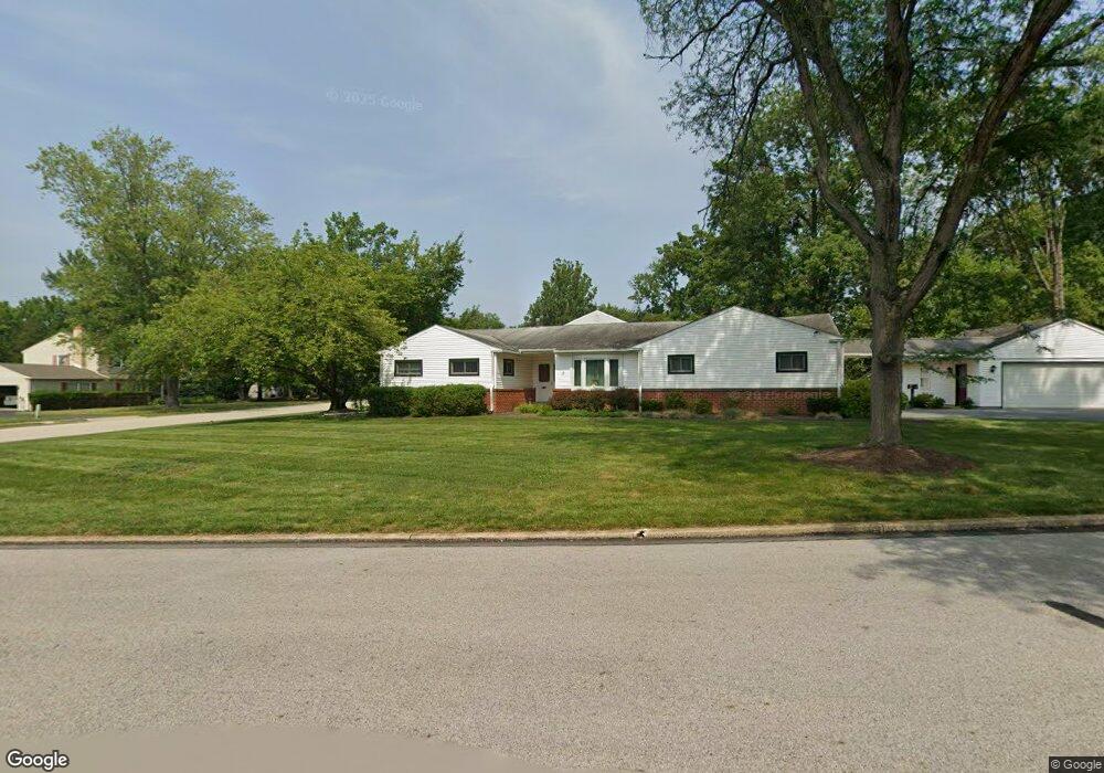
1955 Brandon Rd Norristown, PA 19403
West Norriton Township NeighborhoodEstimated Value: $545,000 - $597,000
3
Beds
3
Baths
2,344
Sq Ft
$242/Sq Ft
Est. Value
About This Home
This home is located at 1955 Brandon Rd, Norristown, PA 19403 and is currently estimated at $567,347, approximately $242 per square foot. 1955 Brandon Rd is a home located in Montgomery County with nearby schools including Charles Blockson Middle School, Paul V Fly Elementary School, and East Norriton Middle School.
Ownership History
Date
Name
Owned For
Owner Type
Purchase Details
Closed on
Jul 5, 2001
Sold by
Giantonio Andrew and Giantonio Jennifer D
Bought by
Korba and Lynn Korba C
Current Estimated Value
Purchase Details
Closed on
Jul 16, 1998
Sold by
Exmore Nathan M and Exmore Warren M
Bought by
Giantonio Andrew and Giantonio Jennifer D
Purchase Details
Closed on
Mar 7, 1995
Sold by
Exmore Nathan M and Exmore Bessie
Bought by
Exmore Warren M
Create a Home Valuation Report for This Property
The Home Valuation Report is an in-depth analysis detailing your home's value as well as a comparison with similar homes in the area
Home Values in the Area
Average Home Value in this Area
Purchase History
| Date | Buyer | Sale Price | Title Company |
|---|---|---|---|
| Korba | $184,000 | -- | |
| Giantonio Andrew | $131,000 | -- | |
| Exmore Warren M | -- | -- |
Source: Public Records
Tax History Compared to Growth
Tax History
| Year | Tax Paid | Tax Assessment Tax Assessment Total Assessment is a certain percentage of the fair market value that is determined by local assessors to be the total taxable value of land and additions on the property. | Land | Improvement |
|---|---|---|---|---|
| 2025 | $7,703 | $157,670 | $49,000 | $108,670 |
| 2024 | $7,703 | $157,670 | $49,000 | $108,670 |
| 2023 | $7,616 | $157,670 | $49,000 | $108,670 |
| 2022 | $7,567 | $157,670 | $49,000 | $108,670 |
| 2021 | $7,521 | $157,670 | $49,000 | $108,670 |
| 2020 | $7,296 | $157,670 | $49,000 | $108,670 |
| 2019 | $7,133 | $157,670 | $49,000 | $108,670 |
| 2018 | $5,574 | $157,670 | $49,000 | $108,670 |
| 2017 | $6,735 | $157,670 | $49,000 | $108,670 |
| 2016 | $6,673 | $157,670 | $49,000 | $108,670 |
| 2015 | $6,183 | $157,670 | $49,000 | $108,670 |
| 2014 | $6,183 | $157,670 | $49,000 | $108,670 |
Source: Public Records
Map
Nearby Homes
- 2044 Mill Rd
- 526 Bassett Ln
- 2017 Yorktown S
- 1905 Yorktown N
- 1914 Yorktown S
- 2012 Yorktown S
- 1924 Juniata Rd
- 307 Brandon Rd
- 402 Brandon Rd
- 533 Brandon Rd
- 167 Woodstream Dr Unit CONDO 167
- 143 Riversedge Dr Unit CONDO 143
- 176 Riversedge Dr
- 121 Woodstream Dr Unit CONDO 121
- 440 Rittenhouse Blvd
- 0 Roosevelt Blvd
- 37 Burnside Ave
- 365 Norris Hall Ln
- 1633 Williams Way
- 2504 Grant Ct
- 2124 Hemlock Rd
- 1958 Brandon Rd
- 2120 Hemlock Rd
- 281 School Ln
- 1962 Brandon Rd
- 2129 Hemlock Rd
- 2133 Hemlock Rd
- 1954 Brandon Rd
- 2125 Hemlock Rd
- 2137 Hemlock Rd
- 271 School Ln
- 2116 Hemlock Rd
- 1950 Brandon Rd
- 2121 Hemlock Rd
- 261 School Ln
- 2141 Hemlock Rd
- 280 School Ln
- 2112 Hemlock Rd
- 1946 Brandon Rd
- 2117 Hemlock Rd Unit 97