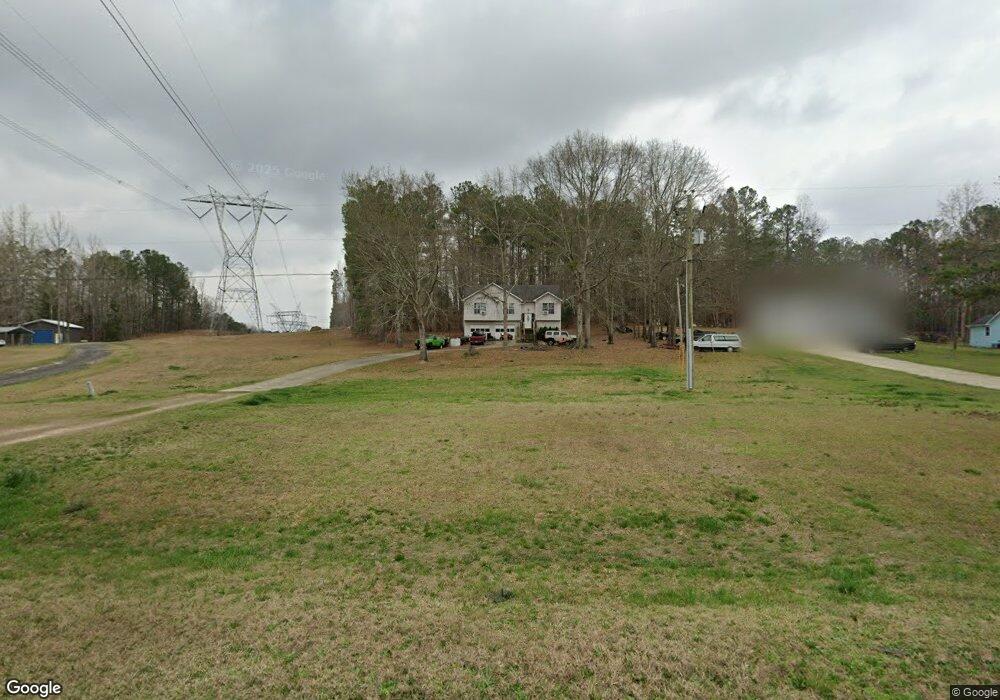
1955 George Brown Rd Franklin, GA 30217
Estimated Value: $203,452 - $226,000
3
Beds
2
Baths
1,024
Sq Ft
$206/Sq Ft
Est. Value
About This Home
This home is located at 1955 George Brown Rd, Franklin, GA 30217 and is currently estimated at $211,363, approximately $206 per square foot. 1955 George Brown Rd is a home located in Heard County with nearby schools including Heard County High School.
Ownership History
Date
Name
Owned For
Owner Type
Purchase Details
Closed on
May 9, 2017
Sold by
Holmes Billie J
Bought by
Holmes Danny G
Current Estimated Value
Purchase Details
Closed on
Mar 25, 1993
Sold by
Fairbanks Angela
Bought by
Holmes Danny G
Purchase Details
Closed on
Dec 1, 1991
Sold by
Ande Construction Co
Bought by
Fairbanks Angela
Purchase Details
Closed on
Oct 1, 1991
Sold by
Fairbanks Robert
Bought by
Ande Construction Co
Purchase Details
Closed on
Jan 1, 1991
Bought by
Fairbanks Robert
Create a Home Valuation Report for This Property
The Home Valuation Report is an in-depth analysis detailing your home's value as well as a comparison with similar homes in the area
Home Values in the Area
Average Home Value in this Area
Purchase History
| Date | Buyer | Sale Price | Title Company |
|---|---|---|---|
| Holmes Danny G | -- | -- | |
| Holmes Danny G | $65,000 | -- | |
| Fairbanks Angela | -- | -- | |
| Ande Construction Co | -- | -- | |
| Fairbanks Robert | -- | -- |
Source: Public Records
Tax History Compared to Growth
Tax History
| Year | Tax Paid | Tax Assessment Tax Assessment Total Assessment is a certain percentage of the fair market value that is determined by local assessors to be the total taxable value of land and additions on the property. | Land | Improvement |
|---|---|---|---|---|
| 2024 | $720 | $52,661 | $4,092 | $48,569 |
| 2023 | $606 | $45,936 | $3,410 | $42,526 |
| 2022 | $434 | $37,730 | $2,114 | $35,616 |
| 2021 | $302 | $30,652 | $2,114 | $28,538 |
| 2020 | $276 | $29,369 | $2,114 | $27,255 |
| 2019 | $276 | $29,369 | $2,114 | $27,255 |
| 2018 | $665 | $29,369 | $2,114 | $27,255 |
| 2017 | $439 | $36,365 | $1,938 | $34,427 |
| 2016 | $776 | $36,365 | $1,938 | $34,427 |
| 2015 | -- | $34,621 | $3,562 | $31,059 |
| 2014 | -- | $34,621 | $3,562 | $31,059 |
| 2013 | -- | $39,590 | $3,562 | $36,028 |
Source: Public Records
Map
Nearby Homes
- 192 Hawk Rd
- 0 Newman Rd Unit 10559645
- 323 Newman Rd
- 220 Dogwood Rd
- 19860 Georgia 34
- 19860 Ga Hwy 34
- 0 Thomas Powers Rd Unit 10569332
- 0 Thomas Powers Rd Unit 5.54+/- ACRES
- 0 Thomas Powers Rd Unit 24228819
- 4230 Joe Stephens Rd
- 642 Elm Rd
- 38 Daniel Cir
- 260 Ancient Oak Ln
- 1227 J D Walton Rd
- 189 & 191 W Plantation Dr
- 17426 Georgia 34
- 712 Boy Scout Rd
- 927 Boy Scout Rd
- 4398 Georgia 34
- 815 Birch Rd
- 1931 George Brown Rd
- 1973 George Brown Rd
- 1991 George Brown Rd
- 1919 George Brown Rd
- 2011 George Brown Rd
- 2035 George Brown Rd
- 1865 George Brown Rd
- 1745 George Brown Rd
- 2104 George Brown Rd
- 2102 George Brown Rd
- 2222 George Brown Rd
- 1701 George Brown Rd
- 2106 George Brown Rd
- 132 Herndon Rd
- 0 George Brown Rd Unit 7486991
- 0 George Brown Rd Unit 8077971
- 0 George Brown Rd Unit 3052562
- 0 George Brown Rd Unit 8878061
- 0 George Brown Rd Unit 3052545
- 0 George Brown Rd Unit 7433351