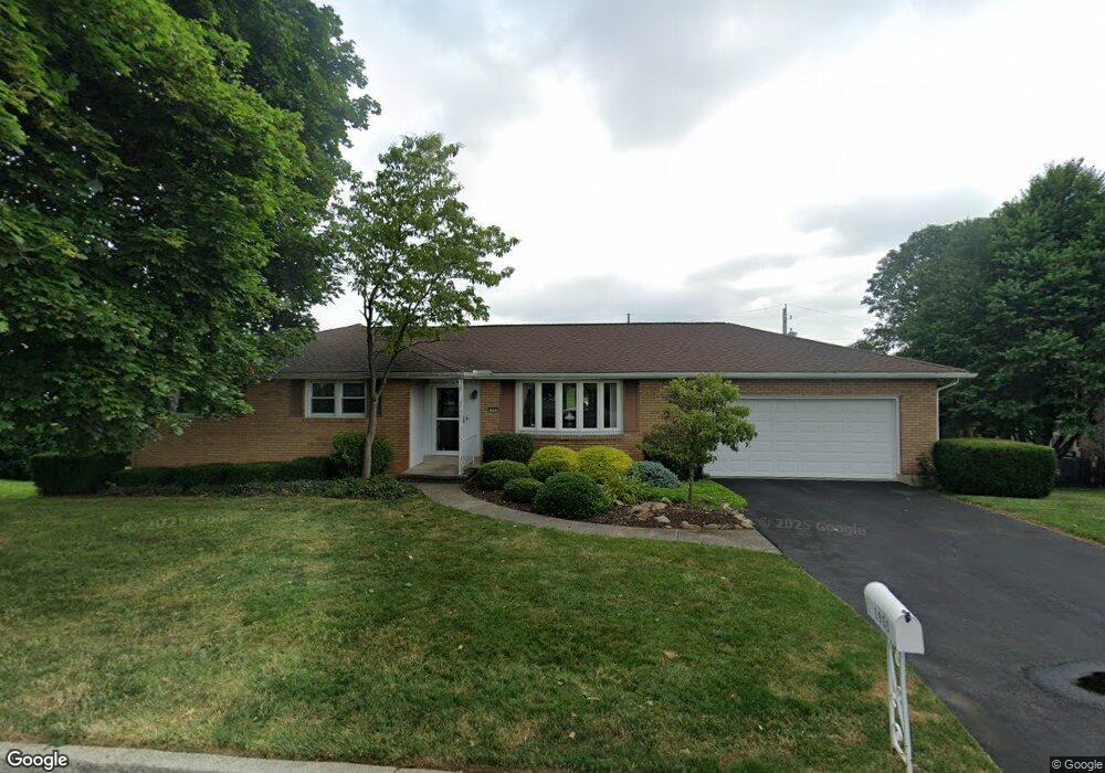
1955 Linden Ln Whitehall, PA 18052
Estimated Value: $362,000 - $466,000
3
Beds
2
Baths
1,476
Sq Ft
$270/Sq Ft
Est. Value
About This Home
This home is located at 1955 Linden Ln, Whitehall, PA 18052 and is currently estimated at $398,398, approximately $269 per square foot. 1955 Linden Ln is a home located in Lehigh County with nearby schools including Zephyr Elementary School, Clarence M Gockley Elementary School, and George D Steckel Elementary School.
Ownership History
Date
Name
Owned For
Owner Type
Purchase Details
Closed on
Apr 30, 1997
Sold by
Jakobsen Phyllis Karen
Bought by
Leester Barrie L and Leester Nancy M
Current Estimated Value
Purchase Details
Closed on
Aug 31, 1993
Sold by
Pratt Ernest R and Pratt Janice A
Bought by
Jakobsen Phyllis Karen
Purchase Details
Closed on
Sep 27, 1988
Sold by
Longenbach Barry L and Longenbach Cynthia J
Bought by
Pratt Ernest R and Pratt Janice A
Purchase Details
Closed on
Dec 9, 1980
Bought by
Longenbach Barry L and Longenbach Cynthia J
Create a Home Valuation Report for This Property
The Home Valuation Report is an in-depth analysis detailing your home's value as well as a comparison with similar homes in the area
Home Values in the Area
Average Home Value in this Area
Purchase History
| Date | Buyer | Sale Price | Title Company |
|---|---|---|---|
| Leester Barrie L | $156,000 | -- | |
| Jakobsen Phyllis Karen | $150,000 | -- | |
| Pratt Ernest R | $147,500 | -- | |
| Longenbach Barry L | $69,800 | -- |
Source: Public Records
Tax History Compared to Growth
Tax History
| Year | Tax Paid | Tax Assessment Tax Assessment Total Assessment is a certain percentage of the fair market value that is determined by local assessors to be the total taxable value of land and additions on the property. | Land | Improvement |
|---|---|---|---|---|
| 2025 | $5,650 | $192,700 | $37,100 | $155,600 |
| 2024 | $5,460 | $192,700 | $37,100 | $155,600 |
| 2023 | $5,348 | $192,700 | $37,100 | $155,600 |
| 2022 | $5,226 | $192,700 | $155,600 | $37,100 |
| 2021 | $5,140 | $192,700 | $37,100 | $155,600 |
| 2020 | $4,942 | $192,700 | $37,100 | $155,600 |
| 2019 | $4,558 | $192,700 | $37,100 | $155,600 |
| 2018 | $4,438 | $192,700 | $37,100 | $155,600 |
| 2017 | $4,357 | $192,700 | $37,100 | $155,600 |
| 2016 | -- | $192,700 | $37,100 | $155,600 |
| 2015 | -- | $192,700 | $37,100 | $155,600 |
| 2014 | -- | $192,700 | $37,100 | $155,600 |
Source: Public Records
Map
Nearby Homes
- 1885 Redwood Dr
- 36 Peachtree Cir
- 1844 Schadt Ave
- 1405 Presidential Dr
- 195 Shiloh Ct
- 125 Cornerstone Place
- 2 Grantarthur #Franklin Ct
- 1313 Hemlock Dr
- 1 Grantartur #Taylor Ct
- 4 Grantarthur #Morris Ct
- 3 Grantarthur #Liberty Ct
- 1 Grantarthur #Taylor Ct
- 1617 Abigail Ln
- 1640 Alta Dr
- 1590 Abigail Ln Unit LOT 59
- 1573 Abigail Ln
- 1630 Alta Dr
- 1590 Alta Dr Unit D11
- 1558 Creekside Rd
- 1723 N 17th St
- 1957 Linden Ln
- 1953 Linden Ln
- 1956 Schadt Ave
- 1954 Schadt Ave
- 1950 Linden Ln
- 1958 Schadt Ave
- 1952 Schadt Ave
- 1956 Linden Ln
- 1961 Linden Ln
- 1947 Linden Ln
- 1960 Linden Ln
- 1960 Schadt Ave
- 1948 Linden Ln
- 1944 Linden Ln
- 1963 Linden Ln
- 1962 Schadt Ave
- 2504 Augusta Dr
- 2503 Augusta Dr
- 1959 Schadt Ave
- 1937 Belleview Dr