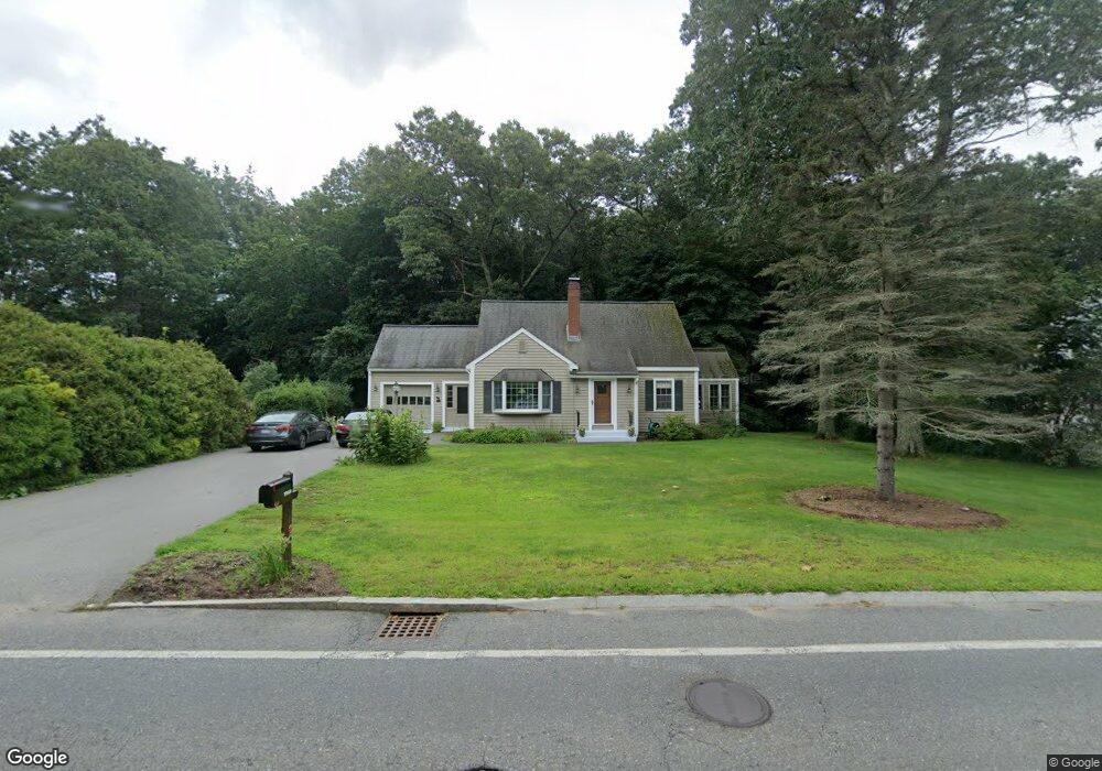
1955 Main St Concord, MA 01742
Estimated Value: $837,000 - $935,000
2
Beds
2
Baths
1,914
Sq Ft
$472/Sq Ft
Est. Value
About This Home
This home is located at 1955 Main St, Concord, MA 01742 and is currently estimated at $903,394, approximately $471 per square foot. 1955 Main St is a home located in Middlesex County with nearby schools including Thoreau Elementary School, Concord Middle School, and Concord Carlisle High School.
Ownership History
Date
Name
Owned For
Owner Type
Purchase Details
Closed on
Jun 13, 2006
Sold by
Mandrioli Peter J
Bought by
Mandrioli Elizabeth W and Mandrioli Peter J
Current Estimated Value
Purchase Details
Closed on
Dec 31, 1990
Sold by
Mandrioli Peter J
Bought by
Mandrioli Peter J
Create a Home Valuation Report for This Property
The Home Valuation Report is an in-depth analysis detailing your home's value as well as a comparison with similar homes in the area
Home Values in the Area
Average Home Value in this Area
Purchase History
| Date | Buyer | Sale Price | Title Company |
|---|---|---|---|
| Mandrioli Elizabeth W | -- | -- | |
| Mandrioli Peter J | $13,500 | -- |
Source: Public Records
Mortgage History
| Date | Status | Borrower | Loan Amount |
|---|---|---|---|
| Previous Owner | Mandrioli Peter J | $100,000 | |
| Previous Owner | Mandrioli Peter J | $5,000 | |
| Previous Owner | Mandrioli Peter J | $40,000 |
Source: Public Records
Tax History
| Year | Tax Paid | Tax Assessment Tax Assessment Total Assessment is a certain percentage of the fair market value that is determined by local assessors to be the total taxable value of land and additions on the property. | Land | Improvement |
|---|---|---|---|---|
| 2025 | $109 | $821,100 | $378,100 | $443,000 |
| 2024 | $10,781 | $821,100 | $378,100 | $443,000 |
| 2023 | $8,749 | $675,100 | $315,100 | $360,000 |
| 2022 | $8,660 | $586,700 | $279,600 | $307,100 |
| 2021 | $8,599 | $584,200 | $279,600 | $304,600 |
| 2020 | $8,114 | $570,200 | $279,600 | $290,600 |
| 2019 | $8,196 | $577,600 | $298,100 | $279,500 |
| 2018 | $7,874 | $551,000 | $296,600 | $254,400 |
| 2017 | $7,563 | $537,500 | $266,300 | $271,200 |
| 2016 | $7,219 | $518,600 | $266,300 | $252,300 |
| 2015 | $6,808 | $476,400 | $246,600 | $229,800 |
Source: Public Records
Map
Nearby Homes
- 1844 Main St Unit 1844
- 100 Harrington Ave
- 27 Water St
- 37 Water St
- 20 Westvale Meadows Unit C
- 66 Old Stow Rd
- 65 Summit St
- 96 Forest Ridge Rd Unit 96
- 22 Center Village Dr
- 95 Conant St Unit 320
- 116 Conant St
- 53 Prairie St
- 70 McCallar Ln
- 31 Drummer Rd Unit 31
- 102 Highland St
- 67 Conant St
- 59 Lexington Dr
- 1 Drummer Rd Unit A5
- 1201 Old Marlboro Rd
- 54 Maple St
Your Personal Tour Guide
Ask me questions while you tour the home.