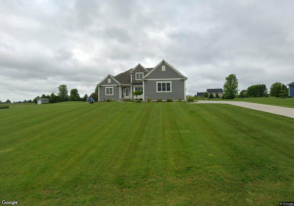
1955 Ravine Ct Slinger, WI 53086
Estimated Value: $616,230 - $727,000
--
Bed
--
Bath
--
Sq Ft
0.92
Acres
About This Home
This home is located at 1955 Ravine Ct, Slinger, WI 53086 and is currently estimated at $655,558. 1955 Ravine Ct is a home with nearby schools including Slinger High School and St Peter Elementary School.
Ownership History
Date
Name
Owned For
Owner Type
Purchase Details
Closed on
May 24, 2016
Sold by
First State Bank
Bought by
Lecke Darren R and Lecke Catherine S
Current Estimated Value
Home Financials for this Owner
Home Financials are based on the most recent Mortgage that was taken out on this home.
Original Mortgage
$390,100
Outstanding Balance
$301,018
Interest Rate
2.75%
Mortgage Type
Adjustable Rate Mortgage/ARM
Estimated Equity
$354,540
Create a Home Valuation Report for This Property
The Home Valuation Report is an in-depth analysis detailing your home's value as well as a comparison with similar homes in the area
Home Values in the Area
Average Home Value in this Area
Purchase History
| Date | Buyer | Sale Price | Title Company |
|---|---|---|---|
| Lecke Darren R | $55,000 | Chicago Title Company Sps Wi |
Source: Public Records
Mortgage History
| Date | Status | Borrower | Loan Amount |
|---|---|---|---|
| Open | Lecke Darren R | $390,100 |
Source: Public Records
Tax History Compared to Growth
Tax History
| Year | Tax Paid | Tax Assessment Tax Assessment Total Assessment is a certain percentage of the fair market value that is determined by local assessors to be the total taxable value of land and additions on the property. | Land | Improvement |
|---|---|---|---|---|
| 2024 | $7,169 | $614,800 | $101,400 | $513,400 |
| 2023 | $6,705 | $482,400 | $78,000 | $404,400 |
| 2022 | $6,842 | $482,400 | $78,000 | $404,400 |
| 2021 | $6,559 | $482,400 | $78,000 | $404,400 |
| 2020 | $6,426 | $419,400 | $72,500 | $346,900 |
| 2019 | $6,381 | $419,400 | $72,500 | $346,900 |
| 2018 | $6,304 | $419,400 | $72,500 | $346,900 |
| 2017 | $4,280 | $274,900 | $69,000 | $205,900 |
| 2016 | $966 | $55,200 | $55,200 | $0 |
| 2015 | $987 | $55,200 | $55,200 | $0 |
| 2014 | $987 | $55,200 | $55,200 | $0 |
| 2013 | $1,030 | $57,000 | $57,000 | $0 |
Source: Public Records
Map
Nearby Homes
- 1900 Hillside Rd
- 2300 Sherman Rd
- 4229 Sherman Rd
- 3790 Sherman Rd
- 3555 Hillside Rd
- 3053 Bogey Ln
- Madison II Plan at Cedar Creek Estates
- Prairiefield II Plan at Cedar Creek Estates
- McKinley I Plan at Cedar Creek Estates
- The Walnut Plan at Cedar Creek Estates
- The Juneberry Plan at Cedar Creek Estates
- Savannah Plan at Cedar Creek Estates
- Hampton Ridge Plan at Cedar Creek Estates
- Jefferson I Plan at Cedar Creek Estates
- Wakefield Plan at Cedar Creek Estates
- 497 Limestone Ln
- Breckenridge I Plan at Cedar Creek Estates
- Hampton Bay Plan at Cedar Creek Estates
- Madison IV Plan at Cedar Creek Estates
- Rivershire Plan at Cedar Creek Estates
- 1950 Ravine Ct
- 1975 Ravine Ct
- 1925 Ravine Ct
- 1970 Ravine Ct
- 1900 Ravine Ct
- 2000 Grandview Dr
- 1905 Ravine Ct
- 2005 Grandview Dr
- 1880 Ravine Ct
- 1895 Ravine Ct
- 1995 Sunny Slope Ct
- 1915 Grandview Dr
- Lt55 Sunny Slope Ct
- 1870 Ravine Ct
- 1875 Ravine Ct
- 1885 Grandview Dr
- 1920 Grandview Dr
- 1900 Highland Ct
- 2025 Grandview Dr
- 1950 Highland Ct