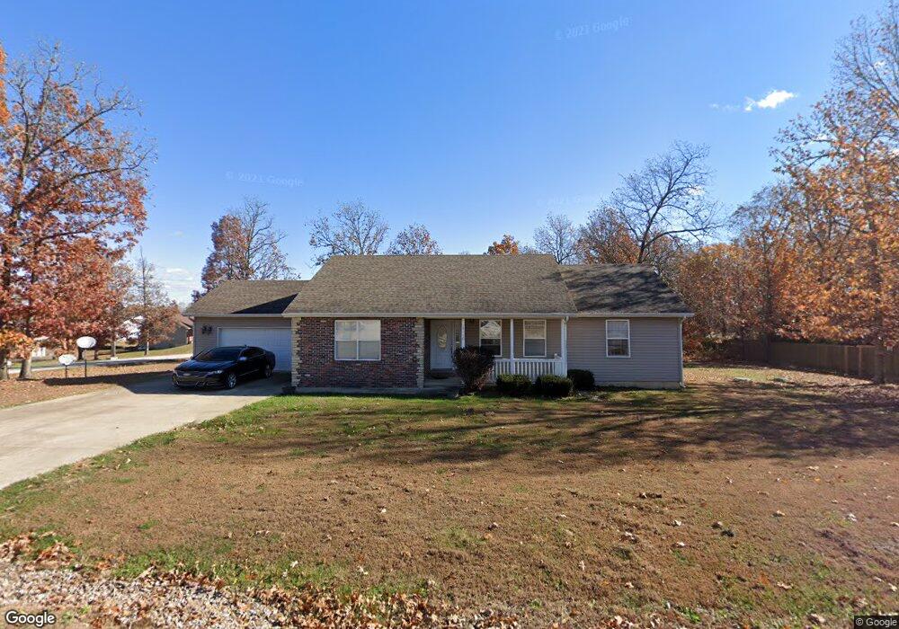
19550 Lenox Ln Waynesville, MO 65583
Estimated Value: $229,000 - $247,000
3
Beds
2
Baths
1,972
Sq Ft
$120/Sq Ft
Est. Value
About This Home
This home is located at 19550 Lenox Ln, Waynesville, MO 65583 and is currently estimated at $236,839, approximately $120 per square foot. 19550 Lenox Ln is a home located in Pulaski County with nearby schools including Waynesville East Elementary School, Freedom Elementary School, and Waynesville Sixth Grade Center.
Ownership History
Date
Name
Owned For
Owner Type
Purchase Details
Closed on
Dec 29, 2006
Sold by
Four J Land And Cattle Company
Bought by
Minor Roberta H
Current Estimated Value
Home Financials for this Owner
Home Financials are based on the most recent Mortgage that was taken out on this home.
Original Mortgage
$141,988
Outstanding Balance
$84,331
Interest Rate
6.1%
Mortgage Type
VA
Estimated Equity
$152,508
Purchase Details
Closed on
Nov 18, 2005
Sold by
Four J Land & Cattle Co
Bought by
Alford Construction L C
Create a Home Valuation Report for This Property
The Home Valuation Report is an in-depth analysis detailing your home's value as well as a comparison with similar homes in the area
Home Values in the Area
Average Home Value in this Area
Purchase History
| Date | Buyer | Sale Price | Title Company |
|---|---|---|---|
| Minor Roberta H | -- | None Available | |
| Alford Construction L C | -- | None Available |
Source: Public Records
Mortgage History
| Date | Status | Borrower | Loan Amount |
|---|---|---|---|
| Open | Minor Roberta H | $141,988 |
Source: Public Records
Tax History Compared to Growth
Tax History
| Year | Tax Paid | Tax Assessment Tax Assessment Total Assessment is a certain percentage of the fair market value that is determined by local assessors to be the total taxable value of land and additions on the property. | Land | Improvement |
|---|---|---|---|---|
| 2024 | $1,210 | $27,812 | $4,750 | $23,062 |
| 2023 | $1,182 | $27,812 | $4,750 | $23,062 |
| 2022 | $1,090 | $27,812 | $4,750 | $23,062 |
| 2021 | $1,078 | $27,812 | $4,750 | $23,062 |
| 2020 | $1,059 | $24,031 | $0 | $0 |
| 2019 | $1,059 | $26,714 | $0 | $0 |
| 2018 | $1,058 | $26,714 | $0 | $0 |
| 2017 | $1,057 | $24,031 | $0 | $0 |
| 2016 | $1,004 | $26,710 | $0 | $0 |
| 2015 | $1,003 | $26,710 | $0 | $0 |
| 2014 | $1,003 | $26,710 | $0 | $0 |
Source: Public Records
Map
Nearby Homes
- 27 London Ln
- 19580 Lyle Ln
- 20465 Leisure Ln
- 19440 Lambert Ln
- 19257 Lambert Ln
- 19252 Lambert Ln
- 20172 London Ln
- 19182 Lonager Ln
- 000 Laduff Rd
- 19583 Ladera Rd
- 19958 Ladera Rd
- 21438 Lancaster Ln
- 0 Tbd Address Unit 23071485
- 19691 Lansing Ln
- 21805 Revere Ln
- 21093 Layla Rd
- 410 Breckenridge Dr
- 508 Shoshone Dr
- 104 Teton Pass
- 96 Teton Pass