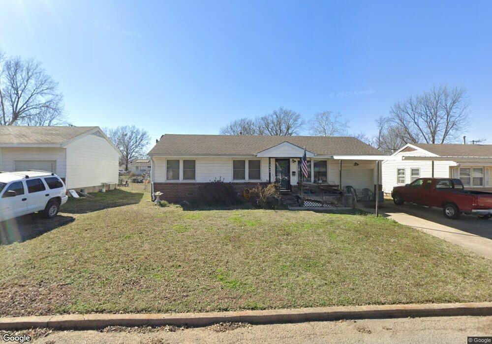
1956 S Scott St Sapulpa, OK 74066
Estimated Value: $116,000 - $139,000
2
Beds
1
Bath
912
Sq Ft
$137/Sq Ft
Est. Value
About This Home
This home is located at 1956 S Scott St, Sapulpa, OK 74066 and is currently estimated at $125,302, approximately $137 per square foot. 1956 S Scott St is a home located in Creek County with nearby schools including Sapulpa Middle School, Sapulpa Junior High School, and Sapulpa High School.
Ownership History
Date
Name
Owned For
Owner Type
Purchase Details
Closed on
Apr 1, 2024
Sold by
Jones Dianna
Bought by
Callahan Jarrod Lee Adam
Current Estimated Value
Home Financials for this Owner
Home Financials are based on the most recent Mortgage that was taken out on this home.
Original Mortgage
$100,000
Outstanding Balance
$92,854
Interest Rate
6.94%
Mortgage Type
Seller Take Back
Estimated Equity
$32,448
Purchase Details
Closed on
Feb 8, 2023
Sold by
Moore Jerry and Moore Kelli
Bought by
Farbro Tommy and Farbro Perrilee
Create a Home Valuation Report for This Property
The Home Valuation Report is an in-depth analysis detailing your home's value as well as a comparison with similar homes in the area
Home Values in the Area
Average Home Value in this Area
Purchase History
| Date | Buyer | Sale Price | Title Company |
|---|---|---|---|
| Callahan Jarrod Lee Adam | $100,000 | None Listed On Document | |
| Farbro Tommy | $65,000 | None Listed On Document |
Source: Public Records
Mortgage History
| Date | Status | Borrower | Loan Amount |
|---|---|---|---|
| Open | Callahan Jarrod Lee Adam | $100,000 |
Source: Public Records
Tax History Compared to Growth
Tax History
| Year | Tax Paid | Tax Assessment Tax Assessment Total Assessment is a certain percentage of the fair market value that is determined by local assessors to be the total taxable value of land and additions on the property. | Land | Improvement |
|---|---|---|---|---|
| 2025 | $829 | $11,412 | $2,400 | $9,012 |
| 2024 | $829 | $6,823 | $1,578 | $5,245 |
| 2023 | $829 | $6,498 | $1,557 | $4,941 |
| 2022 | $711 | $6,188 | $1,532 | $4,656 |
| 2021 | $699 | $5,893 | $1,504 | $4,389 |
| 2020 | $662 | $5,613 | $1,470 | $4,143 |
| 2019 | $634 | $5,345 | $1,421 | $3,924 |
| 2018 | $587 | $4,849 | $1,294 | $3,555 |
| 2017 | $556 | $4,618 | $1,215 | $3,403 |
| 2016 | $503 | $4,398 | $1,139 | $3,259 |
| 2015 | -- | $4,189 | $1,067 | $3,122 |
| 2014 | -- | $3,990 | $999 | $2,991 |
Source: Public Records
Map
Nearby Homes
- 1965 S Scott St
- 605 W Mockingbird Ln
- 1836 S Oklahoma St
- 1915 S Muskogee St
- 1424 S Main St
- 142 W Fairlane Ct
- 119 E Ross Ave
- 41 W Fairlane Ct
- 120 E Burnham Ave
- 273 W Fairlane Dr
- 1220 S Cedar St
- 19 E Fairlane Ct
- 416 W Fairlane Dr Unit A-B
- 211 E Wells Blvd
- 119 E Davis Ave
- 121 E Davis Ave
- 103 E Fairlane Ct
- 925 S Oklahoma St
- 910 S Diane St
- 920 S Oklahoma St
- 1948 S Scott St
- 1964 S Scott St
- 1957 S Independence St
- 1949 S Independence St
- 1965 S Independence St
- 1941 S Independence St
- 1957 S Scott St
- 1949 S Scott St
- 1932 S Scott St
- 1941 S Scott St
- 212 W Mike Ave
- 216 W Mike Ave
- 1933 S Independence St
- 220 W Mike Ave
- 1924 S Scott St
- 1925 S Independence St
- 200 W Mike Ave
- 1956 S Independence St
- 1964 S Independence St